Victorian Resources Online (archived)
Site SW26
| Location: Camperdown. | Australian Soil Classification: Humose, Calcic, Black DERMOSOL (clayey). |
| General Landscape Description: Level plain. | Mapping Unit: Unit 2 (Maher and Martin, 1987). |
| Site Description: Grazing paddock (dairy). | Geology: Quaternary Newer volcanics (scoria). |
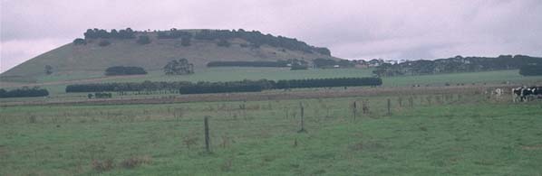 Site SW26 landscape |
Soil Profile Morphology:
Surface Soil
| A1 | 0-10 cm | Black (10YR2/1); light clay; strong medium polyhedral structure; very firm consistence dry; pH 6.7; clear change to: | 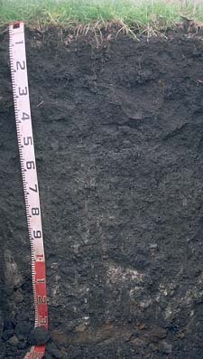 Site SW26 profile photo. |
| Subsoil | |||
| B21 | 10-30 cm | Very dark grey (7.5YR3/0); light clay; strong medium polyhedral, parting to strong fine blocky structure; firm consistence moist; pH 7.7; gradual change to: | |
| B22 | 30-60 cm | Very dark grey (10YR3/1); medium clay; strong medium blocky, parting to strong fine blocky structure; very firm consistence moist; pH 8.5; gradual change to: | |
| B23 | 60-100 cm | Very dark grey (10YR3/1); medium clay; strong medium blocky, parting to strong fine blocky structure; very firm consistence moist; contains a few (5-10 %) calcareous nodules and soft segregations; pH 8.8; gradual change to: | |
| B24 | 100-130 cm | Very dark grey (10YR3/1); medium clay; contains a common (20%) amount of calcareous nodules and soft segregations; pH 8.7; abrupt change to: | |
| C | 130+ cm | Volcanic ash deposits. | |
Key Profile Features:
- Clay texture throughout profile.
Key Profile Characteristics:
pH | Salinity Rating | |||
Surface (A1 horizon) | Slightly Acid | Moderate | Non-Sodic | None1 |
Subsoil (B21 horizon) | Slightly Alkaline | Moderate | Non-Sodic | Strong2 |
Deeper subsoil (at 1 m) | Strongly Alkaline | Moderate | Sodic | Moderate3 |
2. Complete dispersion after remoulding.
3. Strong dispersion after remoulding.
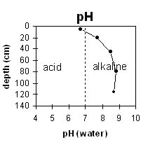 | 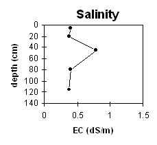 | |||||
The surface horizon is slightly acid. The upper subsoil is slightly alkaline becoming strongly alkaline at 80 cm depth. | The surface has a moderate salinity rating. The subsoil is high at 45 cm then decreases with depth. | |||||
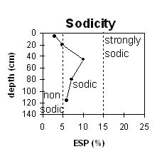 | 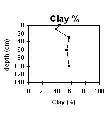 | |||||
The surface is non-sodic. The subsoil becomes sodic at 25-30 cm depth. | The clay content increases gradually down the profile. |
Horizon | Horizon Depth (cm) | pH (water) | pH CaCl2 | EC 1:5 | NaCl % | Exchangeable Cations | |||
Ca | Mg | K | Na | ||||||
meq/100g | |||||||||
A1 | 0-10 | 6.7 | 0.4 | 0.4 | 19 | 11 | 1.7 | 1 | |
B21 | 10-30 | 7.7 | 0.38 | 0.38 | 0.04 | 19 | 18 | 4.8 | 2.8 |
B22 | 30-60 | 8.5 | 0.79 | 0.79 | 0.09 | 16 | 21 | 6.8 | 4.7 |
B23 | 60-100 | 8.8 | 0.4 | 0.4 | 0.03 | 13 | 18 | 6.5 | 2.7 |
B24 | 100-130 | 8.7 | 0.37 | 0.37 | 0.02 | 13 | 16 | 5.4 | 2.3 |
C | 130+ | ||||||||
Horizon | Horizon Depth (cm) | Field Capacity pF2.5 | Wilting Point pF4.2 | Coarse Sand (0.2-2.0 mm) | Fine Sand (0.02-0.2 mm) | Silt (0.002-0.02 mm) | Clay (<0.002 mm) |
A1 | 0-10 | 63 | 37 | 8 | 15 | 17 | 44 |
B21 | 10-30 | 64 | 40 | 3 | 14 | 32 | 39 |
B22 | 30-60 | 70 | 43 | 1 | 7 | 24 | 57 |
B23 | 60-100 | 61 | 38 | 1 | 5 | 22 | 54 |
B24 | 100-130 | 0 | 34 | 1 | 6 | 10 | 57 |
C | 130+ |
Profile Described By: Mark Imhof and Austin Brown, August 1998.