Victorian Resources Online (archived)
Site SW27
| Location: Bostock Creek. | Australian Soil Classification: Vertic (& Ferric), Subnatric, Grey SODOSOL. |
| General Landscape Description: Grazing paddock (dairy). | Mapping Unit: Unit 113 (Maher and Martin, 1987). |
| Site Description: Lower slope within gently undulating hills. | Geology: Quaternary - Newer volcanics (scoria). |
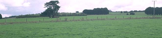 Site SW27 Landscape |
Soil Profile Morphology:
Surface Soil
| A11 | 0-15 cm | Black (10YR2/1); fine sandy clay loam; weak to moderate medium polyhedral, parting to moderate fine polyhedral structure; firm to very firm consistence (dry); weak-firm consistence (moist); pH 6.1; gradual change to: | 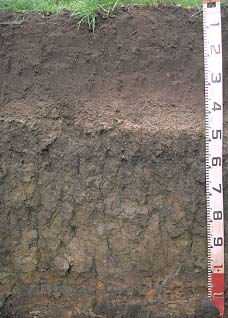 Site SW27 profile |
| A12 | 15-40 cm | Very dark grey (10YR3/1); fine sandy clay loam; moderate medium polyhedral, parting to moderate fine polyhedral structure; weak-firm consistence (moist); pH 5.8; abrupt change to: | |
| A2 | 40-50 cm | Brown (10YR5/3), conspicuously bleached (7.5YR7/2d); fine sandy clay loam; apedal; contains very many (> 50%) ferruginous nodules (2-6 mm in size); pH 6.5; sharp change to: | |
| Subsoil | |||
| B21 | 50-70 cm | Very dark greyish brown becoming dark greyish brown (2.5Y4/2) with depth, with yellowish brown (10YR5/6) mottles; heavy clay; moderate very coarse prismatic, parting to moderate coarse to medium polyhedral structure; strong consistence (dry); pH 6.5; gradual change to: | |
| B22 | 70-100 cm | Greyish brown (2.5Y5/2) with yellowish brown (10YR5/8) mottles; heavy clay; strong very coarse prismatic, parting to coarse prismatic and very coarse blocky structure; strong consistence (dry); many slickensides present; pH 7.0; abrupt change to: | |
| C | 100+ cm | Weathered ash. | |
Key Profile Features:
- Strong texture contrast between surface (A) horizons and subsoil (B21) horizon.
Key Profile Characteristics:
pH | Salinity Rating | ||
Surface (A1 horizon) | Slightly Acid | Low-Medium | Non-Sodic |
Subsoil (B21 horizon) | Slightly Acid | Low | Sodic |
Deeper subsoil (at 70-100 cm) | Neutral | Low | Sodic |
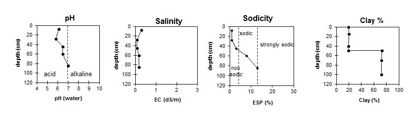 |
Horizon | Horizon Depth (cm) | pH (water) | pH CaCl2 | EC 1:5 | NaCl % | Exchangeable Cations | |||
Ca | Mg | K | Na | ||||||
meq/100g | |||||||||
A11 | 0-15 | 6.1 | 5.7 | 0.29 | 0.02 | 14 | 2.3 | 0.6 | 0.1 |
A12 | 15-40 | 5.8 | 5 | 0.09 | 6.7 | 2.1 | 0.1 | 0.1 | |
A2 | 40-50 | 6.5 | 5.6 | 0.08 | 4.5 | 2.2 | <0.1 | 0.2 | |
B21 | 50-70 | 6.5 | 5.8 | 0.18 | 5.8 | 9.6 | 0.2 | 1.4 | |
B22 | 70-100 | 7 | 6.1 | 0.18 | 4.7 | 11 | 0.2 | 2.4 | |
C | 100+ | ||||||||
Horizon | Horizon Depth (cm) | Field Capacity pF2.5 | Wilting Point pF4.2 | Coarse Sand (0.2-2.0 mm) | Fine Sand (0.02-0.2 mm) | Silt (0.002-0.02 mm) | Clay (<0.002 mm) |
A11 | 0-15 | 39 | 18 | 6 | 39 | 22 | 19 |
A12 | 15-40 | 34 | 11 | 5 | 46 | 22 | 20 |
A2 | 40-50 | 26 | 11 | 29 | 33 | 15 | 19 |
B21 | 50-70 | 56 | 35 | 4 | 12 | 5 | 73 |
B22 | 70-100 | 26 | 32 | 3 | 14 | 8 | 72 |
C | 100+ |
Profile Described By: Mark Imhof and Austin Brown, August 1988.