Land Systems
Cassilis Valley, Swifts Creek | Land Inventory of East Gippsland | A Study of the Land in the Catchment of the Gippsland Lakes - Volume 1 | A Study of the Land in the Catchment of Gippsland Lakes - Volume 2 | A Study of the Land in the Victorian Catchment of Lake Hume | Reconnaissance survey of ecology & land-use - Glenmaggie Res. Catchment | A Study of the Land in the Tyers River Catchment
The former Soil Conservation Authority began an inventory of Victoria's lands in the 1950's, led by R.G Downes who saw the need to include data on land characteristics and processes in planning land use and management. The Land Systems method was subsequently developed, with Frank Gibbons, Jim Rowan and Ken Rowe (amongst others) prominent in its application. The resultant studies identify Land Systems and their land components. These studies provide information on factors affecting production, susceptibility to processes of soil degradation, and land management.
The Land Systems method involves an ecological approach - integrating environmental features often mapped singly, e.g. rainfall, geology, topography, soils and indigenous vegetation. Patterns occur, governed by climate, geology and landform, which interact over time to influence the distribution of soils and vegetation. A Land System is therefore a complex mapping unit that contains a pattern of land components each of which has little variation in climate, lithology (rock type), landform, soil and indigenous vegetation. The land component can therefore be regarded as a unit of management for broad-scale uses such as dryland farming or forestry.
| Land System surveys have generally resulted in maps at 1:100 000 to 1:250 000 scale being produced. Many of these published studies describe (but do not map) the individual components of each Land System. A consistent statewide coverage of Land Systems (at 1:250 000 scale) was developed by Jim Rowan (1990) and has subsequently been updated with new information. A number of Land System survey reports will be made available on this site over time as downloadable reports. Reference: Rowan, J. (1990). Land Systems of Victoria. Department of Conservation and Environment and Land Conservation Council. | 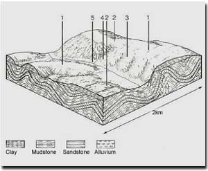 Example of a Land System and it's five land components |