Victorian Resources Online (archived)
Profile Number 28
| Laboratory number: | 0942 | 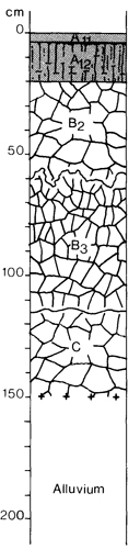 | Profile Description | ||
| Site number: | 389 | All | 0 - 3 cm | Very dark grey (10YR 3/1) silty clay loam; common distinct yellowish brown (5 - 15 mm) mottles; moderate medium (10 mm) subangular blocky structure; rough-ped fabric; porous; slightly hard when thy; abundant grass roots; pH 6.0; clear smooth boundary | |
| Classification: | Northcote (1979) - Uf6.41 | Al2 | 3 - 20 cm | Very dark grey (10YR 3/1) medium clay; common distinct yellowish brown (5 - 15 mm) mottles; moderate prismatic (80 mm) structure; rough-ped fabric; porous; very hard when dry; common grass roots; pH 8.0; clear smooth boundary | |
| Location: | Stace et al. (1972) - Humic Gley Traralgon 8221, grid ref. 898837 11 km NE of Rosedale | B2 | 20 - 60 cm | Dark grey (2.5Y 4/1) heavy clay; common prominent yellowish brown (5 - 15 mm) mottles; strong medium (10 mm) angular blocky structure; smooth-ped fabric; porous; very firm when moist; few roots; irregular boundary | |
| Land system, component: | Nambrok, 2 | B3 | 60 - 115 cm | Yellowish brown (10YR 5/6) heavy clay; common prominent grey (<5 mm) mottles; strong fine (5 mm) angular blocky structure; smooth-ped fabric; very firm when moist; few roots; pH 9.5; clear wavy boundary | |
| Topography: | Drainage depression on alluvial terrace, 0% slope | C | 115 - 150 cm | Yellowish brown (10YR 5/6) heavy clay; common prominent grey (5 - 15 mm) mottles; moderate coarse (20 mm) angular blocky structure; smooth-ped fabric; very firm when moist; few roots; pH 9.5 | |
| Elevation: | 20 m | ||||
| Drainage: | Poor | ||||
| Parent material: | Pleistocene fine-textured alluvium | ||||
| Vegetation: | Cleared; mostly grasses, rushes and sedges | ||||
| Remarks: | Watertable at 174 cm at time of sampling (July) | ||||
| LABORATORY ANALYSES 942 | |||||||||||||||||||
Horizon | Sample Depth cm | Lab. texture | Particle size distribution | Atterberg limits | 1:5 soil water suspension | Clay mineralogy by x-ray diffraction | |||||||||||||
Gravel % | Coarse sand % f.e. | fine sand % f.e. | Silt % f.e. | Clay % f.e. | liquid limit % | plastic limit % | plasticity index % | linear shrinkage % | pH | EC 25°C uS/cm | Cl- % | Depth cm | Composition % | ||||||
All Al2 B2 B3 C | 0 - 3 10 - 20 30 - 60 60 - 90 120 - 150 | SiC SiC SiC C SiC | 1 0 0 1 1 | 1 <1 1 1 <1 | 12 10 7 5 4 | 34 36 27 23 29 | 41 49 63 70 66 | 59 15 | 44 | 14 | 5.8 8.1 9.3 9.2 8.5 | 830 530 1400 1400 480 | 0.10 0.059 0.15 0.15 0.051 | ||||||
Horizon | Sample Depth cm | Org. C % | Total N % | 1.3C N | Free Fe2O3 % | Available | HCl extract | Exchangeable cations | |||||||||||
P ppm | K ppm | P % | K % | Ca | Mg | K | Na | CEC | Ca % of CEC | Mg | K | Na | H | ||||||
Milliequivalents/100g | |||||||||||||||||||
All | 0 - 3 | 6.63 | 0.57 | 15 | 1.3 | 68 | 420 | 0.047 | 0.51 | 3.9 | 8.2 | 1.6 | 3.9 | 33.7 | 12 | 24 | 5 | 12 | 47 |
Al2 | 10 - 20 | 1.23 | 0.13 | 12 | 1.8 | 3 | 220 | 0.011 | 0.61 | 2.9 | 8.4 | 0.8 | 5.2 | 20.9 | 14 | 40 | 4 | 25 | 17 |
B2 | 30 - 60 | 2.2 | 0.009 | 0.71 | 2.7 | 9.8 | 1.0 | 11.6 | 25.6 | 11 | 38 | 4 | 45 | 2 | |||||
B3 | 60 - 90 | 2.5 | 0.008 | 0.85 | 2.7 | 9.6 | 0.5 | 9.3 | 22.1 | 12 | 44 | 2 | 42 | 0 | |||||
C | 120 - 150 | 2.7 | 0.008 | 0.71 | 2.1 | 10.6 | 0.3 | 6.5 | 20.0 | 11 | 53 | 2 | 33 | 1 | |||||