Victorian Resources Online (archived)
Profile Number 51
| Laboratory number: | 0958 | 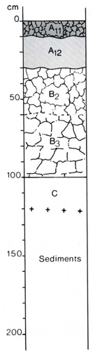 | Profile Description | ||
| Site number: | 405 | A11 | 0-10 cm | Very dark grey (10YR 3/1) sandy clay loam; weak fine (6 mm) subangular blocky structure; rough-ped fabric; firm when moist; abundant roots; pH 6.0; clear wavy boundary | |
| Classification: | Northcote (1979) – Dy3.21 Stace et al (1972) - Soloth | A12 | 10-30 cm | Very dark greyish brown (10YR 3/2) sandy clay loam; apedal, earthy fabric; very firm when moist; abundant roots; pH 6.0; clear wavy boundary | |
| Location: | Bairnsdale 8422, grid ref. 751084 Road cutting on Nungurner Road,15km W of Lake Entrance | B2 | 30-60 cm | Yellowish brown (10YR 5/4) heavy clay; abundant distinct dark brown (5-15 mm) and yellow (<5 mm) mottles; moderate coarse (30 mm) subangular blocky (almost primary columnar) structure; rough-ped fabric; hard when dry; common roots, abundant organic matter along root lines; pH 6.8; gradual wavy boundary | |
| Land system, component: | Westbury 1, 2 | B3 | 60-100 cm | Yellowish brown (10YR 5/6) sandy clay; abundant distinct grey (>15 mm) and reddish brown (5-15 mm) mottles; weak coarse (40 mm) angular blocky structure; rough-ped fabric; very hard when dry; few roots; pH 6.0; clear smooth boundary | |
| Topography: | Mid-slope of hill, NSW aspect, 5%slope | C | 100-120 cm | Brownish yellow (10YR 6/8) sandy clay loam; abundant distinct grey (>15 mm) mottles; apedal; earthy fabric; very hard when dry; pH 5.5. | |
| Elevation: | 40 m | ||||
| Drainage: | Moderate | ||||
| Parent material: | Tertiary and Pleistocene fine-textured sediments | ||||
| Vegetation: | Cleared: grassland with scattered Eucalyptus tereticornis and E. bosistoana | ||||
| LABORATORY ANALYSES 958 | |||||||||||||||||||
Horizon | Sample Depth cm | Lab. texture | Particle size distribution | Atterberg limits | 1:5 soil water suspension | Clay mineralogy by x-ray diffraction | |||||||||||||
Gravel % | Coarse sand % f.e. | fine sand % f.e. | Silt % f.e. | Clay % f.e. | liquid limit % | plastic limit % | plasticity index % | linear shrinkage % | pH | EC 25°C µS/cm | Cl- % | Depth cm | Composition % | ||||||
A11 | 0-10 | SL | 5 | 33 | 41 | 8 | 12 | 4.8 | 59 | 0.005 | |||||||||
A12 | 20-30 | LS | 2 | 33 | 45 | 11 | 9 | 5.7 | 26 | 0.002 | |||||||||
B2 | 30-60 | C | 1 | 20 | 33 | 6 | 40 | 5.1 | 26 | 0.002 | |||||||||
B3 | 60-90 | SC | 2 | 23 | 40 | 2 | 33 | 5.1 | 390 | 0.043 | |||||||||
B3 | 90-100 | SCL | 1 | 26 | 43 | 7 | 22 | 5.1 | 400 | 0.043 | |||||||||
Horizon | Sample Depth cm | Org. C % | Total N % | 1.3C N | Free Fe2O3 % | Available | HCl extract | Exchangeable cations | |||||||||||
P ppm | K ppm | P % | K % | Ca | Mg | K | Na | CEC | Ca % of CEC | Mg | K | Na | H | ||||||
Milliequivalents/100g | |||||||||||||||||||
A11 | 0-10 | 1.89 | 0.15 | 16 | 0.8 | 19 | 80 | 0.011 | 0.12 | 27 | 1.6 | 0.2 | 0.2 | 14.8 | 18 | 11 | 1 | 1 | 69 |
A12 | 20-30 | 0.68 | 0.046 | 19 | 0.8 | 2 | 40 | 0.007 | 0.12 | 1.3 | 2.4 | 0.1 | 0.3 | 9.2 | 14 | 26 | 1 | 3 | 56 |
B2 | 30-60 | 2.1 | 2.1 | 0.005 | 0.27 | 0.4 | 6.3 | 0.2 | 3.1 | 14.9 | 3 | 42 | 1 | 21 | 33 | ||||
B3 | 60-90 | 1.6 | 1.6 | 0.004 | 0.27 | 0.3 | 5.6 | 0.1 | 3.5 | 13.6 | 2 | 41 | 1 | 26 | 30 | ||||
B3 | 90-100 | 1.4 | 1.4 | 0.004 | 0.29 | 0.29 | 4.3 | 0. | 2.8 | 9.9 | 2 | 43 | 1 | 28 | 26 | ||||