Victorian Resources Online (archived)
Profile Number 52
| Laboratory number: | 0966 | 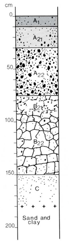 | Profile Description | ||
| Site number: | 484 | A1 | 0-10 cm | Very dark greyish brown (10YR3/1) sandy loam; apedal; earthy fabric; hard when dry; 2% fine quartz gravel up to 5 mm; pH 4.5; clear boundary | |
| Classification: | Northcote (1979) – Dy3.31 Stace et al (1972) – Yellow Podzolic soil | A21 | 10-30 cm | Dark brown to brown (10YR 4/3) fine sand; apedal; earthy fabric; hard when dry; 5% fine quartz gravel up to 5 mm; 2% ferruginous nodules up to 20 mm; pH 4.5; abrupt smooth boundary | |
| Location: | Stratford 8322; grid ref. 162168 Roadcuttng, 12km NE of Briagolong | A22 | 30-75 cm | Yellowish brown (10YR 5/4) gravelly fine sand; apedal; earthy fabric; very firm when moist; 20% quartz gravel up to 30 mm, 60% ferruginous nodules up to 30 mm; pH 5.0; abrupt smooth boundary | |
| Land system, component: | Stockdale, 1 | B21 | 75-90 cm | Yellowish brown (10YR 5/6) fine sandy clay; abundant prominent reddish brown and dark grey (>15 mm) mottles; weak coarse (20 mm) angular blocky structure; smooth-ped fabric; very firm when moist; 5% fine quartz gravel up to 5 mm; pH 5.0; gradual wavy boundary | |
| Topography: | Lower slope of hill, S aspect, 4% gradient | B22 | 90-150 cm | Yellowish brown (10YR 5/8) medium clay; abundant prominent reddish brown and grey (>15 mm) mottles; moderate medium (30 mm) angular blocky structure; smooth-ped fabric; very firm when moist; 5% fine quartz gravel up to 5 mm; pH 5.5; clear boundary | |
| Elevation: | 120 m | C | 150-180 cm | Yellowish brown (10YR 5/6) fine sand; abundant prominent reddish brown (>15 mm) mottles; apedal; earthy fabric; extremely hard dry; pH 5.0. | |
| Drainage: | Good | ||||
| Parent material: | Tertiary sand and clay | ||||
| Vegetation: | Pinus radiata forest | ||||
| LABORATORY ANALYSES 966 | |||||||||||||||||||
Horizon | Sample Depth cm | Lab. texture | Particle size distribution | Atterberg limits | 1:5 soil water suspension | Clay mineralogy by x-ray diffraction | |||||||||||||
Gravel % | Coarse sand % f.e. | fine sand % f.e. | Silt % f.e. | Clay % f.e. | liquid limit % | plastic limit % | plasticity index % | linear shrinkage % | pH | EC 25°C µS/cm | Cl- % | Depth cm | Composition % | ||||||
A1 | 0-10 | LS | 4 | 19 | 62 | 8 | 7 | 5.1 | 67 | 0.007 | |||||||||
A21 | 20-30 | LS | 9 | 17 | 66 | 9 | 7 | 5.6 | 15 | 0.001 | |||||||||
A22 | 30-60 | L | 26 | 16 | 60 | 12 | 13 | 5.5 | 12 | 0.001 | |||||||||
B21 | 75-90 | SC | 5 | 16 | 43 | 1 | 38 | 5.6 | 21 | 0.001 | |||||||||
B22 | 90-120 | C | 4 | 12 | 36 | 11 | 38 | 46 | 21 | 25 | 13 | 5.4 | 30 | 0.002 | |||||
C | 150-180 | SL | 5 | 18 | 62 | 4 | 13 | 5.9 | 31 | 0.005 | |||||||||
Horizon | Sample Depth cm | Org. C % | Total N % | 1.3C N | Free Fe2O3 % | Available | HCl extract | Exchangeable cations | |||||||||||
P ppm | K ppm | P % | K % | Ca | Mg | K | Na | CEC | Ca % of CEC | Mg | K | Na | H | ||||||
Milliequivalents/100g | |||||||||||||||||||
A1 | 0-10 | 13 | 0.050 | 34 | 0.4 | 3 | 10 | 0.004 | 0.022 | 0.14 | 0.26 | 0.01 | 0.12 | 11.5 | 1 | 2 | <1 | 1 | 96 |
A21 | 20-30 | 0.61 | 0.022 | 36 | 0.5 | 0.003 | 0.024 | 0.03 | 0.14 | <0.01 | 0.07 | 7.8 | <1 | 2 | <1 | 1 | 97 | ||
A22 | 30-60 | 0.6 | 0.003 | 0.023 | 0.07 | 0.09 | <0.01 | 0.08 | 4.9 | 1 | 2 | <1 | 2 | 95 | |||||
B21 | 75-90 | 2.3 | 0.005 | 0.10 | 0.1 | 0.7 | 0.04 | 0.3 | 9.2 | 1 | 8 | <1 | 3 | 88 | |||||
B22 | 90-120 | 2.5 | 0.005 | 0.14 | 0.05 | 0.8 | 0.05 | 0.4 | 12.6 | <1 | 6 | <1 | 3 | 91 | |||||
C | 150-180 | 1.7 | 0.003 | 0.07 | 0.09 | 1.0 | 0.04 | 0.6 | 4.8 | 2 | 21 | 1 | 12 | 64 | |||||