Victorian Resources Online (archived)
Profile Number 66
| Laboratory number: | 0944 | 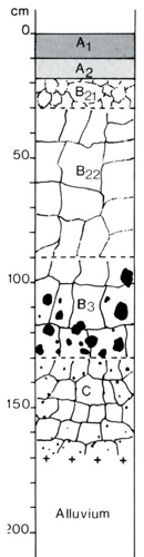 | Profile Description | ||
| Site number: | 391 | A1 | 0-10 cm | Very dark greyish brown (10YR 3/2) clay loam; common distinct yellowish brown (<5 mm) mottles; weak coarse (20 mm) subangular blocky structure; porous; rough-ped fabric; hard when dry; abundant grass roots; pH 5.8; clear smooth boundary | |
| Classification: | Northcote (1979) – Dy3.23 Stace et al (1972) – Solodic Soil | A2 | 10-18 cm | Dark greyish brown (10YR 4/2) clay loam; common distinct yellowish brown (<5 mm) mottles; apedal; earthy fabric; very hard when dry; abundant grass roots; pH 5.5; clear smooth boundary | |
| Location: | Traralgon 8221, grid ref. 767918 4 km E of Cowwarr | B21 | 18-30 cm | Yellowish brown (10YR 5/6) medium clay; common prominent grey (5-15 mm) mottles; weak coarse (30 mm) subangular blocky structure; porous; rough-ped fabric; very hard when dry; pH 8.5; smooth gradual boundary | |
| Land system, component: | Valencia, 1 | B22 | 30-90 cm | Strong brown (7.5YR4/6) heavy clay; common faint yellowish brown (5-15 mm) mottles; moderate very coarse (60 mm) angular blocky structure; smooth-ped fabric; extremely hard when dry; common roots; pH 8.5; smooth gradual boundary | |
| Topography: | Pleistocene alluvial terrace, 0% slope | B3 | 90-130 cm | Dark yellowish brown (10YR 4/4) heavy clay; few distinct red (5-15 mm) mottles; moderate; very coarse (70 mm) angular blocky structure; smooth-ped fabric; extremely hard when dry; 20% gravel or nodules up to 80 mm; common roots; pH 8.7: smooth gradual boundary | |
| Elevation: | 60 m | C | 130-170 cm | Dark red (2.5YR 3/6) heavy clay; strong medium (15 mm) angular blocky structure; smooth-ped fabric; very hard when dry; 5% manganiferous nodules up to 5 mm; pH 8.5 | |
| Drainage: | Poor | ||||
| Parent material: | Pleistocene fine-textured alluvium | ||||
| Vegetation: | Cleared; grassland with Paspalum dilatatum, Poa australis and Romulea rosea | ||||
| LABORATORY ANALYSES 944 | |||||||||||||||||||
Horizon | Sample Depth cm | Lab. texture | Particle size distribution | Atterberg limits | 1:5 soil water suspension | Clay mineralogy by x-ray diffraction | |||||||||||||
Gravel % | Coarse sand % f.e. | fine sand % f.e. | Silt % f.e. | Clay % f.e. | liquid limit % | plastic limit % | plasticity index % | linear shrinkage % | pH | EC 25°C µS/cm | Cl- % | Depth cm | Composition % | ||||||
A1 | 0-10 | SiL | 0 | 4 | 28 | 37 | 23 | 5.5 | 95 | 0.010 | |||||||||
A2 | 10-18 | SiL | 0 | 5 | 30 | 13 | 5.4 | 63 | 0.007 | ||||||||||
B21 | 20-30 | SiCL | 0 | 4 | 30 | 39 | 26 | 5.7 | 56 | 0.006 | |||||||||
B22 | 30-60 | C | 1 | 1 | 9 | 17 | 71 | 7.5 | 330 | 0.036 | |||||||||
B3 | 90-120 | C | 0 | <1 | 11 | 20 | 67 | 8.4 | 900 | 0.11 | |||||||||
Horizon | Sample Depth cm | Org. C % | Total N % | 1.3C N | Free Fe2O3 % | Available | HCl extract | Exchangeable cations | |||||||||||
P ppm | K ppm | P % | K % | Ca | Mg | K | Na | CEC | Ca % of CEC | Mg | K | Na | H | ||||||
Milliequivalents/100g | |||||||||||||||||||
A1 | 0-10 | 3.17 | 0.29 | 14 | 1.4 | 15 | 220 | 0.026 | 0.29 | 1.8 | 1.9 | 0.6 | 0.5 | 17.6 | 10 | 11 | 3 | 3 | 73 |
A2 | 10-18 | 1.43 | 0.14 | 13 | 1.9 | 9 | 60 | 0.017 | 0.24 | 1.0 | 1.3 | 0.3 | 0.4 | 13.4 | 7 | 10 | 2 | 3 | 78 |
B21 | 20-30 | 0.59 | 0.065 | 12 | 2.7 | 47 | 30 | 0.012 | 0.29 | 0.9 | 2.1 | 0.2 | 0.6 | 10.8 | 8 | 19 | 2 | 6 | 65 |
B22 | 30-60 | 4.6 | 0.011 | 0.92 | 3.0 | 11.2 | 1.0 | 4.5 | 25.1 | 12 | 45 | 4 | 18 | 21 | |||||
B3 | 90-120 | 4.1 | 0.011 | 0.87 | 1.9 | 9.9 | 0.8 | 5.7 | 20.4 | 9 | 49 | 4 | 28 | 10 | |||||