Victorian Resources Online (archived)
Archived content — This page contains material from the Victorian Resources Online (VRO) website. It is no longer maintained and is provided for reference only. This content is hosted by CeRDI and is not endorsed by Agriculture Victoria.
Sitemap
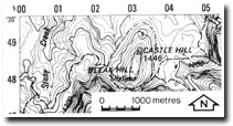
8322-9 Castle Hill
|
This information has been developed from the publications:
- Sites of Geological and Geomorphological Significance in Central Gippsland (1981) by Neville Rosengren, M.S McRae-Williams and S.M Kraemers.
- Sites of Geological and Geomorphological Significance in the Gippsland Lakes Catchment (1984) by Neville Rosengren.
- Sites of Geological and Geomorphological Significance in East Gippsland, Victoria (1981) by Neville Rosengren, M.S McRae-Williams
Geological heritage sites, including sites of geomorphological interest and volcanic heritage sites, are under regular revision by the Geological Society of Australia, especially in the assessment of significance and values. Reference should be made to the most recent reports. See the Earth Science Heritage section of the Geological Society of Australia website for details of geological heritage reports, and a bibliography. |
Location: |
032486. 15 kilometres west of Waterford. | |
Abstract: |
Small plateau with exposures of Mount Ken Conglomerate and Wellington Rhyolite. |
Access: |
Castle Hill Track and Junction Spur Track. |
Ownership: |
Crown land. |
Geology/Geomorphology: |
Castle Hill is a small plateau cliffed on three sides and preserved by a capping of sandstone and conglomerates of the Avon River Group. The conglomerate overly Wellington Rhyolite. |
Significance: |
Local. Characteristic landform associated with the Mount Kent Conglomerate. | |
Management: |
Because of the area covered by the site, the value of the significant geological/geomorphologic features are unlikely to be seriously reduced except by extensive quarrying. | |