Victorian Resources Online (archived)
Archived content — This page contains material from the Victorian Resources Online (VRO) website. It is no longer maintained and is provided for reference only. This content is hosted by CeRDI and is not endorsed by Agriculture Victoria.
Sitemap
8523-12 Springs Creek
|
This information has been developed from the publications:
- Sites of Geological and Geomorphological Significance in Central Gippsland (1981) by Neville Rosengren, M.S McRae-Williams and S.M Kraemers.
- Sites of Geological and Geomorphological Significance in the Gippsland Lakes Catchment (1984) by Neville Rosengren.
- Sites of Geological and Geomorphological Significance in East Gippsland, Victoria (1981) by Neville Rosengren, M.S McRae-Williams
Geological heritage sites, including sites of geomorphological interest and volcanic heritage sites, are under regular revision by the Geological Society of Australia, especially in the assessment of significance and values. Reference should be made to the most recent reports. See the Earth Science Heritage section of the Geological Society of Australia website for details of geological heritage reports, and a bibliography. |
Location: |
147694. 7.5 kilometres north-east of Mt Murrindal. | 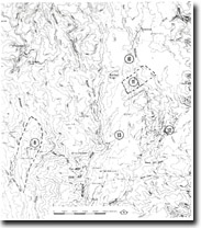
Sites 8523 9 to 13 |
Abstract: |
Waterfall, landslide and exposures of Snowy River Volcanics. |
Access: |
Springs Track from Tullock Ard Road. |
Ownership: |
Crown land. |
Geology/Geomorphology: |
Springs Creek rises in a plateau in Snowy River Volcanics and plunges over a series of falls and rapids to its junction with Butchers Creek. Undercutting of valley sides has resulted in the formation of landslides. |
Significance: |
Local. |
Management: |
Instability of slopes is evidenced by landslides. Land use incompatible with the maintenance of land stability and of the water fall/hanging valley features should be avoided. |