Victorian Resources Online (archived)
EGC202
Location: Doctors Flat
Australian Soil Classification: Eutrophic, Subnatric, Red SODOSOL
Map Unit: Dargo (Component 1)
Previous Site Name: EG202
General Landscape Description: Rolling low hills
Site description: Mid north-west facing slope (8% slope)
Land Use: Grazing on annual pasture
Native Vegetation: Grassy woodland
Geology: Palaeozoic granite
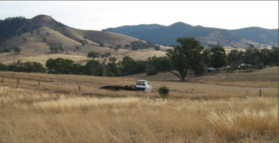
Rolling low hills of the Dargo map unit in the foreground, steep hills of the Bloomfield map unit in the background
Soil Profile Morphology:
| Surface soil | 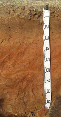 | ||
| A1 | 0 – 20 cm | Reddish brown (10YR4/3); sandy loam; weak fine (2 – 10 mm) granular structure; weak consistence dry; clear change to: | |
| A2 | 20 – 35 cm | Yellowish red (10YR5/6); sandy loam (light); apedal; firm consistence dry; abrupt change to: | |
| Subsoil | |||
| B21 | 35 – 60 cm | Red (2.5YR4/6); light medium clay; weak coarse (20 – 50 mm) polyhedral structure; strong consistence dry; gradual change to: | |
| B22 | 60 – 90+ cm | Reddish brown (5YR5/4); medium clay; moderate coarse (20 – 50 mm) lenticular structure; strong consistence dry; very few (<2 %) fine manganiferous veins. |
Key Profile Features:
- Strong texture contrast between the surface (A) horizons and the subsoil (B) horizons.
Soil Profile Characteristics:
- | pH | Salinity | ||
Surface soil (A1 horizon) | Slightly Acid | Very Low | Non-sodic | None1 |
Subsoil (B21 horizon) | Slightly Alkaline | Very Low | Strongly Aodic | Strong2 |
Deeper subsoil (60-90cm) | Slightly Alkaline | Very Low | Strongly Aodic | Strong2 |
Chemical and Physical Analysis:
Horizon | Horizon Depth (cm) | pH (water) | EC dS/m | Organic Carbon % | Total Nitrogen % | Exchangeable Aluminium ppm | Exchangeable Acididty meq/100g | Exchangeable Cations | Coarse Sand (0.2-2.0 mm) % | Fine Sand (0.02-0.2 mm) % | Silt (0.002-0.02 mm) % | Clay (<0.002 mm) % | Field Capacity % w/w | Wilting Point % w/w | |||
Ca | Mg | K | Na | ||||||||||||||
meq/100g | |||||||||||||||||
A1 | 0-20 | 6.1 | 0.06 | 1.5 | 0.09 | <10 | 3.6 | 3.8 | 0.58 | 0.24 | 0.16 | 40 | 40 | 9 | 7 | 12.5 | 4.0 |
A2 | 20-35 | 6.1 | 0.05 | 0.54 | <0.05 | <10 | 1.9 | 2.1 | 0.4 | 0.17 | 0.17 | 39 | 44 | 9 | 5 | 9.4 | 3.2 |
B21 | 35-60 | 7.5 | 0.06 | 0.38 | 2.5 | 4.4 | 3.1 | 0.16 | 1.1 | 31 | 32 | 10 | 23 | 20.9 | 11.0 | ||
B22 | 60-90 | 7.9 | 0.16 | 0.45 | 7.2 | 8.7 | 0.3 | 3.6 | 23 | 22 | 8 | 43 | 33.9 | 18.6 | |||
Management Considerations
Whole profile
- Plant available water content for this profile is considered to be very low, as the effective rooting depth is largely limited to the surface horizons due to the dense and coarsely structured nature of the strongly sodic subsoil.
- The low wilting point (4 and 3.2%) of the surface soils indicates the plants are able to utilise very light rains when the soil is dry. However, due to the low water storage capacity, plants will soon suffer moisture stress unless further rains occur.
- The organic matter content of the soil is very low. Such levels result in a very poor structural condition and very low structural stability.
- The surface soil is moderately acid. As the pH is well above 5.5, a pasture response to lime additions is unlikely.
- Potassium is low to deficiency levels for pastures.
- Salinity is not a problem in the surface soil.
- The nutrient holding capacity of the surface (A1 and A2) horizons is very low (based on the sum of the exchangeable calcium, magnesium, potassium and sodium cations).
- The dense and coarsely structured upper subsoil is strongly sodic. Root and water movement is likely to be restricted although the red colour of the subsoil indicates the soil is generally well drained. Gypsum in association with deep ripping has been used to ameliorate sodic subsoils but here this would be not an economic option.
- The subsoil and the deep subsoil are strongly dispersive. If the subsoil is exposed, for example by a gully head, headward erosion is highly likely.
Profile Described By: Heather Adams, Julieanne Sargant and Ian Sargeant, June 2009.