Victorian Resources Online (archived)
EGC209
Location: Lindenow
Australian Soil Classification: Melanic, Eutrophic, Brown KANDOSOL
Map Unit: Lindenow (Component 1)
Previous Site Name: EG209
General Landscape Description: Level plain.
Site Description: <1% slope
Land Use: Vegetable production
Native Vegetation: Dry valley forest, minor areas of floodplain reed-bed
Geology: Recent alluvium
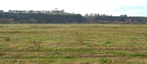
EG209 Landscape
Soil Profile Morphology:
Surface Soil
| A11 | 0 – 15 cm | Dark brown (7.5YR3/2); silty loam; moderate fine granular structure; weak consistence dry; pH 5.9; clear change to: | 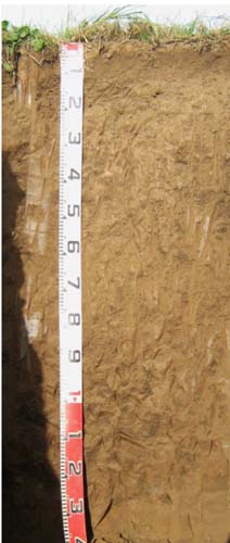 EG209 Profile |
| Subsurface soil | |||
| A12 | 15 – 40 cm | Dark brown (7.5YR3/2); silty loam; weak coarse polyhedral structure; firm consistence dry; pH 5.6; gradual change to: | |
| A13 | 40 – 70 cm | Brown (7.5YR4/2); silty loam; apedal; firm consistence dry; pH 6.4; gradual change to: | |
| A14 | 70 – 110 cm | Brown (7.5YR4/2); silty loam; apedal; weak consistence dry; pH 6.5; gradual change to: | |
| A15 | 110 – 140 cm | Brown (7.5YR4/2); silty loam. |
Key Profile Features:
- Uniform textures throughout.
Soil Profile Characteristics:
pH | |||
Surface soil | Slightly acid | Non-sodic | None |
Subsurface (A12 horizon) | Moderately acidic | Non-sodic | None1 |
Deeper subsoil (70-110 cm) | Slightly acid | Non-sodic | None2 |
Chemical and Physical Analysis:
Horizon | Horizon Depth (cm) | pH (water) | pH (CaCl2) | EC dS/m | Organic Carbon % | Total Nitrogen % | Exch. Al ppm | Exch. Acididty meq/100g | Exchangeable Cations | Coarse Sand (0.2-2.0 mm) % | Fine Sand (0.02-0.2 mm) % | Silt (0.002-0.02 mm) % | Clay (<0.002 mm) % | Field cap. % w/w | Wilt. point % w/w | |||
Ca | Mg | K | Na | |||||||||||||||
meq/100g | ||||||||||||||||||
A11 | 0-15 | 5.9 | 5.1 | 0.06 | 3.1 | 0.17 | <10 | 8.5 | 8.2 | 2.3 | 0.14 | 0.23 | 2 | 44 | 19 | 26 | 28.9 | 9.6 |
A12 | 15-40 | 5.6 | 4.7 | 0.05 | 2.2 | 0.10 | <10 | 8.9 | 7 | 2.3 | 0.095 | 0.15 | 0 | 46 | 31 | 16 | 28.2 | 8.2 |
A13 | 40-70 | 6.4 | 5.4 | 0.05 | 1.8 | <0.05 | <10 | 5.7 | 6.5 | 4.2 | 0.083 | 0.23 | 0 | 48 | 30 | 15 | 20.1 | 7.1 |
A14 | 70-110 | 6.5 | 5.5 | 0.05 | 1.6 | 0.05 | 4.4 | 5.8 | 5 | 0.091 | 0.32 | 0 | 46 | 28 | 19 | 26.3 | 5.7 | |
Management Considerations
Whole profile
- The brown colours throughout and lack of texture contrast indicate the profile is well drained internally.
- Plant available water content capacity is considered to be low to moderate, (estimated at 62 mm) based on the laboratory data and an effective rooting depth of 70 cm.
Surface (A11) horizon
- The soil has a normal organic matter content conferring average structural stability,
- The nutrient holding capacity of the soil is moderate (based on the sum of exchangeable cations),
- The potassium levels are low and the soil is expected to show a strong response to potassium fertilisers.
Subsurface soils
- The soil has no impeding layers to restrict root development.
Profile Described By: Ian Sargeant, Julieanne Sargant, and Heather Adams, June 2009.