Victorian Resources Online (archived)
EGC210
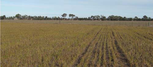
Location: Bengworden
Australian Soil Classification: Vertic (and Magnesic), Brown SODOSOL
Map Unit: Fernbank
Previous Site Name: EG210
General Landscape Description: Level plain
Site Description: Level, slope <1 %
Land Use: Millet
Native Vegetation: Plains grassy woodland
Geology: Pleistocene alluvium (Qp2)
Soil Profile Morphology:
Surface Soil
| A1 | 0 – 10 cm | Dark brown (10YR3/3); sandy loam; weak fine granular structure; very weak consistence moist; clear change to: | 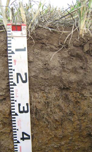 |
| A2 | 10 – 10/30 cm | Brown (10YR5/3), conspicuously bleached (10YR7/2d); loamy sand; apedal; weak consistence dry; sharp wavy change to: | |
| Subsoil | |||
| B21 | 10/30 – 50 cm | Yellowish brown (10YR5/6); medium to heavy clay; strong coarse columnar structure parting to strong fine polyhedral structure; very firm moist; diffuse change to: | |
| B22 | 50 – 75 cm | Dark yellowish brown (10YR4/6) distinct red (2.5YR4/6) mottles; medium to heavy clay; moderate coarse lenticular structure; very firm moist; diffuse change to: | |
| B23 | 75 – 120 cm | Mottled brown (10YR5/3) and red (2.5YR4/6); medium to heavy clay; moderate coarse lenticular structure; very firm moist |
Key Profile Features:
- Strong texture contrast between the surface horizons (A1 and A2) and the subsoil horizons (B).
- Bleached subsurface soil.
- Lenticular structure in the deep subsoil, indicating swelling and shrinking between wet and dry conditions.
Soil Profile Characteristics:
| - | pH | ||
Surface soil (A1 horizon) | Moderately acidic | Non sodic | None1 |
Subsoil (B21 horizon) | Moderately acidic | Sodic | None2 |
Deeper subsoil (75-120 cm) | Moderately acidic | Strongly sodic | None |
Chemical and Physical Analysis:
Horizon | Horizon Depth (cm) | pH (water) | pH (CaCl2) | EC dS/m | Organic Carbon % | Total Nitrogen % | Exch. Al ppm | Exch. Acididty meq/100g | Exchangeable Cations | Coarse Sand (0.2-2.0 mm) % | Fine Sand (0.02-0.2 mm) % | Silt (0.002-0.02 mm) % | Clay (<0.002 mm) % | Field cap. % w/w | Wilt. point % w/w | |||
Ca | Mg | K | Na | |||||||||||||||
meq/100g | ||||||||||||||||||
A1 | 0-10 | 5.8 | 5.2 | 0.17 | 2.1 | <0.05 | <10 | 5.9 | 4.4 | 1.9 | 0.34 | 0.36 | 23 | 44 | 14 | 13 | 18.3 | 7.3 |
A2 | 10+/30 | 5.7 | 4.6 | <0.05 | 1.0 | 0.063 | 11 | 4.4 | 1.1 | 0.84 | 0.075 | 0.18 | 28 | 45 | 16 | 6 | 15.9 | 4.3 |
B21 | 10/30-50 | 5.9 | 4.7 | 0.08 | 0.89 | <0.05 | 100 | 12 | 2.2 | 9.3 | 0.2 | 1.6 | 7 | 13 | 7 | 69 | 42.6 | 26.4 |
B22 | 50-75 | 5.9 | 4.8 | 0.15 | 0.61 | <0.05 | 84 | 11 | 1.1 | 11 | 0.24 | 2.4 | 4.6 | 9.7 | 9 | 72 | 46.4 | 27.7 |
B23 | 75-120 | 5.6 | 4.7 | 0.23 | 0.38 | <0.05 | 99 | 8.9 | 0.3 | 8.2 | 0.14 | 3.3 | 8.4 | 17.3 | 10 | 62 | 37.1 | 20.5 |
Management Considerations
Whole profile
- Plant available water is considered to be low (estimated at 63 mm) for this profile based on an effective rooting depth of 35 mm. The dense and coarsely structured upper subsoil is likely to restrict root depth. Most of the plant available water will be in the A1 horizon as the A2 horizon will be seasonally saturated. Roots in the subsoil will be confined to cracks in the soil and not penetrate deeply
Surface (A) horizons
- The surface soil is moderately acid but is highly unlikely to affect plant growth.
- Potassium levels are moderate.
- The surface (A1) horizon has a low nutrient holding capacity. Organic matter is important for maintaining nutrient and water holding capacity, especially in sandy soils.
- The low wilting points of the surface soils indicates plants will be able to use very light rains when the soil is dry. Due to the low water storage capacity of the surface soils, plants will soon suffer moisture stress unless follow-up rains occur.
Subsoil (B) horizons
- The dense and coarsely structured subsoil is strongly sodic and is strongly dispersive. This will result in significantly restricted root and water movement. As the photo shows, roots do move through the cracks between the soil aggregates in the upper part of this horizon. The use of gypsum in association with deep ripping has been advocated by some researchers as an effective way to ameliorate sodic subsoils.
- The levels of exchangeable aluminium are medium-high and may affect deep-rooted, aluminium sensitive species.
Profile Described By: Ian Sargeant, Julieanne Sargant, and Heather Adams, June 2009.