Victorian Resources Online (archived)
EGC213
Location: Cann River flats
Australian Soil Classification: Vertic (Mottled-Sodic), Eutrophic, Grey DERMOSOL
Map Unit: River flats (rf)
Previous Site Name: EG213
General Landscape Description: Alluvial plain
Site description: Level plain >1% slope
Land Use: Grazing
Native Vegetation: Riparian forest
Geology: Recent sediments
Soil Profile Morphology:
| Surface soil | 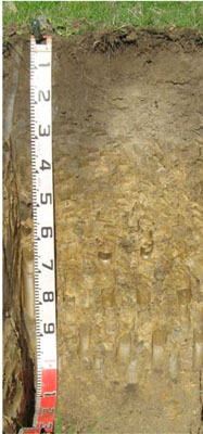 | ||
A11 | 0 – 15 cm | Very dark greyish brown (10YR3/2); silty clay loam; moderate fine granular structure; weak consistence moist; pH 6.4; diffuse change to: | |
A12 | 15 – 35 cm | Dark greyish brown (10YR4/2); silty clay loam; weak medium polyhedral structure; firm consistence moist; pH 5.9; diffuse change to: | |
| Subsoil | |||
B21 | 35 – 70 cm | Dark greyish brown (10YR4/2) with common distinct medium yellowish brown (10YR5/6) mottles; silty clay; moderate coarse polyhedral structure; very firm consistence moist; pH 6.4; change to: | |
B22 | 70 – 110 cm | Grey (10YR5/1) with common distinct medium yellowish brown (10YR5/6) mottles; light clay; moderate coarse lenticular structure; very firm consistence moist; pH 8.3. |
Key Profile Features:
- Lack of strong texture contrast between the surface (A11 & A12) horizons and the subsoil (B1) horizon.
- Coarsely structured deep subsoil.
Soil Profile Characteristics:
- | pH | Salinity | ||
Surface soil (A11 horizon) | Slightly acid | Low | Non sodic | None |
Subsoil (B21 horizon) | Slightly acid | Very low | Sodic | Strong |
Deeper subsoil (70 -110 cm) | Moderately alkaline | Very low | Strongly sodic | Strong |
Chemical and Physical Analysis:
Horizon | Horizon Depth (cm) | pH (water) | pH (CaCl2) | EC dS/m | Organic Carbon % | Total Nitrogen % | Exch. Al ppm | Exch. Acididty meq/100g | Exchangeable Cations | Coarse Sand (0.2-2.0 mm) % | Fine Sand (0.02-0.2 mm) % | Silt (0.002-0.02 mm) % | Clay (<0.002 mm) % | Field cap. % w/w | Wilt. point % w/w | |||
Ca | Mg | K | Na | |||||||||||||||
meq/100g | ||||||||||||||||||
A11 | 0-15 | 6.4 | 6.2 | 0.27 | 4.8 | 0.39 | <10 | 11.0 | 14.0 | 3.1 | 0.44 | 0.13 | 6 | 24 | 36 | 20 | 41.3 | 18.9 |
A12 | 15-35 | 5.9 | 5.1 | 0.09 | 1.7 | 0.07 | 26 | 12.0 | 3.5 | 3.9 | 0.062 | 0.59 | 6 | 23 | 36 | 28 | 33.3 | 15.1 |
B21 | 35-70 | 6.4 | 5.5 | 0.15 | 0.73 | <10 | 7.8 | 1.5 | 6.1 | 0.07 | 1.8 | 4 | 26 | 34 | 31 | 29.1 | 15.3 | |
B22 | 70-110 | 8.3 | 7.0 | 0.17 | 0.44 | 1.3 | 9.1 | 0.066 | 3.7 | 0 | 33 | 28 | 34 | 32.0 | 18.1 | |||
Management Considerations
Whole Profile
- Plant available water capacity (PAWC) is considered to be moderate-high (estimated at 65 mm) for this soil profile. This is based on an estimated effective rooting depth of 60 cm (i.e. surface soil and upper subsoil). The denser and more coarsely structured deeper subsoil is likely to restrict rooting depth.
- Infiltration of water will be rapid throughout the upper soil profile due to the well developed structure and pore space available.
Surface (A) Horizons
- The relatively deep surface soil is moderately well structured and is friable when moist. Soil consistence when moist is also weak for this horizon. As a result of these attributes the surface soil will provide excellent seed-bed conditions, creating few limitations to root and water movement.
- The surface (A1) horizon has a moderate nutrient holding capacity (based on the sum of the exchangeable calcium, magnesium and potassium cations).
- The surface soil has moderate potassium content and no response to potassium fertilizer would be expected. However below this depth, the level of potassium is very low.
- The surface soil has high organic matter content. Soils such as these rely on organic matter to maintain soil structure. Maintaining organic matter levels will also assist in improving soil fertility and water holding capacity.
- Infiltration of water into the well structured surface soil will be quite high and this horizon will be well drained.
Subsoil (B) Horizons
- The deep subsoil is sodic and coarsely structured which will significantly restrict deeper root and water movement.
Profile Described By: Ian Sargeant, Heather Adams, and Julieanne Sargant, June 2009.