Victorian Resources Online (archived)
EGC214
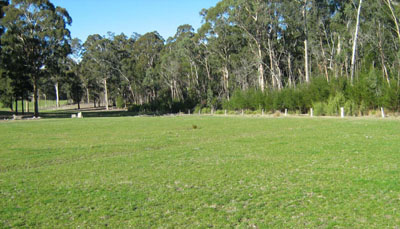
Location: Cann River flats
Australian Soil Classification: Vertic (& Acidic-Sodic), Eutrophic, Grey DERMOSOL
Map Unit: River terrace (Component 6)
Previous Site Name: EG214
General Landscape Description: Alluvial plain
Site description: Terrace flat >1% slope
Land Use: Grazing
Native Vegetation: Riparian forest
Geology: Recent sediments
Soil Profile Morphology:
| Surface soil | 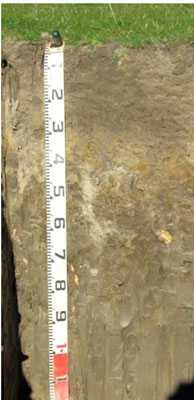 | ||
A1 | 0 – 25 cm | Very dark greyish brown (10YR3/2); light clay; moderate medium granular structure; weak consistence moist; pH 5.9; clear change to: | |
Subsoil | |||
B21 | 25 – 60 cm | Dark grey (10YR4/1) mottled with dark yellowish brown; medium clay; moderate coarse polyhedral structure; very firm consistence moist; pH 5.6; diffuse change to: | |
B21 | 60 -90 mm | Dark greyish brown (10YR4/2); heavy clay; weak coarse polyhedral structure; pH 5.4; diffuse change to: | |
B22 | 90 – 120 cm | Greyish brown (10YR5/2); heavy clay; moderate coarse lenticular structure; very firm moist; weak coarse polyhedral structure; pH 5.3. |
Key Profile Features:
- Little change in soil texture down the profile
- Coarsely structured below the surface horizon.
Soil Profile Characteristics:
- | pH | Salinity | ||
Surface soil (A1 horizon) | Moderately acid | Very low | Non sodic | None |
Subsoil (B21 horizon) | Moderately acid | Very low | Non sodic | None1 |
Deeper subsoil (90 -120 cm) | Strongly acid | Higher than normal | Sodic | Slight |
Chemical and Physical Analysis:
Horizon | Horizon Depth (cm) | pH (water) | pH (CaCl2) | EC dS/m | Organic Carbon % | Total Nitrogen % | Exch. Al ppm | Exch. Acididty meq/100g | Exchangeable Cations | Coarse Sand (0.2-2.0 mm) % | Fine Sand (0.02-0.2 mm) % | Silt (0.002-0.02 mm) % | Clay (<0.002 mm) % | Field cap. % w/w | Wilt. point % w/w | |||
Ca | Mg | K | Na | |||||||||||||||
meq/100g | ||||||||||||||||||
A1 | 0-25 | 5.9 | 5.2 | 0.12 | 2.6 | 0.2 | <10 | 6.8 | 2.7 | 0.15 | 0.37 | 3 | 27 | 20 | 41 | 36.7 | 12.8 | |
B21 | 25-60 | 5.6 | 4.5 | 0.07 | 0.92 | <0.05 | 51 | 7.9 | 3 | 4.7 | 0.053 | 0.63 | 2 | 27 | 21 | 45 | 30.9 | 14.7 |
B22 | 60-90 | 5.4 | 4.4 | 0.18 | 0.37 | <0.05 | 75 | 9.4 | 4.2 | 11 | 0.14 | 2.2 | 0 | 17 | 22 | 55 | 41.1 | 21.8 |
B23 | 90-120 | 5.3 | 4.5 | 0.29 | 0.37 | <0.05 | 69 | 8.4 | 3.1 | 9.5 | 0.09 | 1.8 | 0 | 16 | 15 | 54 | 43.5 | 21.9 |
Management Considerations
Whole Profile
- Plant available water content is moderate (estimated at 75 mm) for this soil profile. This is based on an estimated effective rooting depth of 50 cm (i.e. surface soil and upper subsoil). The denser and more coarsely structured deeper subsoil is likely to restrict rooting depth.
- Infiltration of water will be slow throughout the upper soil profile due to the high clay content of the soil profile.
Surface (A) Horizons
- The level of soluble salts in the surface is low.
- Potassium levels are very low and a response to potassium fertilizer would be expected.
- The surface (A1) horizon has a moderate nutrient holding capacity based on the sum of the exchangeable calcium, magnesium and potassium cations).
- The organic matter content is high resulting in good structural condition and high structural stability. Maintaining the level of organic matter is important in maintaining the water and nutrient holding capacity of the soil.
Subsoil (B) Horizons
- The coarsely structured deeper subsoil (from 60 cm depth) is sodic and has low exchangeable calcium to magnesium ratios (0.4). It is also strongly dispersive and slakes considerably. These conditions are likely to result in more restricted root and water movement in the deeper subsoil.
- Deep rooted species such as lucerne may be adversely affected by the high levels of aluminium in the subsoil.
Profile Described By: Ian Sargeant, Heather Adams, and Julieanne Sargant, June 2009.