Victorian Resources Online (archived)
EGC215
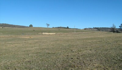
Location: Wulgulmerang
Australian Soil Classification: Bleached-Mottled, Mesotrophic, Grey KANDOSOL (strong)
Map Unit: Wulgulmerang (Component 1)
Previous Site Name: EG215
General Landscape Description: Rolling hills
Site Description: Mid-slope of a low hill, >3 % slope
Land Use: Grazing
Native Vegetation: Montane dry woodland
Geology: Devonian acid volcanics (Snowy River Volcanics)
Soil Profile Morphology:
| Surface Soil | 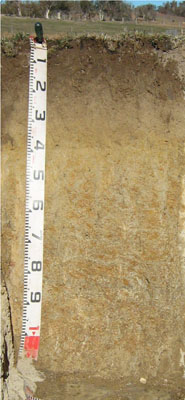 | ||
| A1 | 0 – 18 cm | Dark brown (10YR3/3); sandy loam; weak fine granular structure; very weak consistence moist; pH 5.4; diffuse change to: | |
| A2 | 18 – 40 cm | Brown (10YR5/3) conspicuously bleached (10YR8/2d); sandy loam; massive; few surrounded quartz gravels; pH 5.6; clear change to: | |
| Subsoil | |||
| B21 | 40 -80 mm | Light grey (10YR7/2) with common medium distinct yellowish brown (10YR5/6) mottles; sandy clay; massive; common angular tabular medium pebbles; pH 5.6; gradual change to: | |
| B2 | 80 – 120 cm | Very pale brown (10YR7/3) with many coarse distinct dark yellowish brown (10YR4/4) mottles; clayey sand; abundant angular tabular medium pebbles; pH 5.6. |
Key Profile Features:
- Weak texture contrast between the surface (A1 & A2) horizons and the subsoil (B21) horizon.
- Conspicuously bleached subsurface (A2) horizon.
- Lack of soil structure development.
Soil Profile Characteristics:
- | pH | Salinity | ||
Surface soil (A1 horizon) | Strongly Acid | Very Low | Non-Sodic | None |
Subsoil (B21 horizon) | Moderately Acid | Very Low | Non-Sodic | None1 |
Deeper Subsoil (80 -120 cm) | Moderately Acid | Very Low | Non-Sodic | Moderate |
Chemical and Physical Analysis:
Horizon | Horizon Depth (cm) | pH (water) | pH (CaCl2) | EC dS/m | Organic Carbon % | Total Nitrogen % | Exchangeable Aluminium ppm | Exchangeable Acididty meq/100g | Exchangeable Cations | Coarse Sand (0.2-2.0 mm) % | Fine Sand (0.02-0.2 mm) % | Silt (0.002-0.02 mm) % | Clay (<0.002 mm) % | Field Capacity % w/w | Wilting Point % w/w | |||
Ca | Mg | K | Na | |||||||||||||||
meq/100g | ||||||||||||||||||
A1 | 0-15 | 5.4 | 4.5 | <0.05 | 2 | 0.13 | 21 | 8.0 | 3.3 | 0.79 | 0.23 | 0.1 | 48 | 22 | 16 | 7 | 24.8 | 8.0 |
A2 | 15-40 | 5.6 | 4.4 | <0.05 | 0.43 | <0.05 | 65 | 4.0 | 2 | 0.85 | 0.11 | 0.18 | 45 | 23 | 16 | 11 | 21.3 | 7.0 |
B21 | 40-80 | 5.6 | 4.0 | <0.05 | <0.30 | <0.05 | 340 | 7.5 | 1 | 3.2 | 0.17 | 0.39 | 31 | 22 | 14 | 30 | 30.9 | 13.4 |
B22 | 80-120 | 5.6 | 4.0 | <0.05 | <0.30 | <0.05 | 400 | 6.3 | 0.76 | 2.7 | 0.12 | 0.56 | 59 | 13 | 11 | 13 | 21.0 | 8.7 |
Management Considerations
Whole profile
- The profile is moderately, bordering on strongly acid throughout.
- These soils are moderately well drained due to the high sand content.
- Plant available water capacity is considered to be low estimated at 60 mm based on the laboratory data and an effective root depth of 80 cm.
- Exchangeable aluminium levels are high, which mean than the soil is not suited to aluminium sensitive crops such as lucerne.
- The soil has low organic matter content.
- The low wilting point of the surface horizons indicates that plants will be able to use light rains when the soil is dry. Due to the low water storage capacity of the soil, plants will suffer water stress unless further rains occur.
- The nutrient holding capacity of the soil is low (based on the sum of the exchangeable basic cations).
- Potassium levels are very low and a strong response to potassium fertilisers would be expected.
- The subsoil has very low inherent fertility.
- As the subsoil has extremely high exchangeable aluminium content, root development of aluminium sensitive species into this zone will be restricted.
Profile Described By: Heather Adams, Julieanne Sargant, and Ian Sargeant, June 2009.