Victorian Resources Online (archived)
EGC216
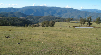
Location: Gelantipy
Australian Soil Classification: Haplic, Eutrophic, Red FERROSOL (Stony)
Map Unit: Gelantipy (Component 1)
Previous Site Name: EG216
General Landscape Description: Plateau
Site Description: Gently undulating plain, <2% slope, few (2 - 10%) scattered rounded basalt stones (200 – 600 mm)
Land Use: Grazing
Native Vegetation: Montane grassy woodland
Geology: Tertiary basalt
Soil Profile Morphology:
| A11 | 0 – 20 cm | Dark reddish brown (5YR3/4); heavy clay loam; strong fine granular structure; common subrounded cobbles; weak consistence moist; pH 5.8; gradual change to: | 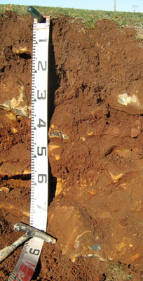 |
| A12 | 20 – 40 cm | Dark red (2.5YR3/6); light clay; strong fine polyhedral structure; many subrounded cobbles; firm consistence dry; pH 6.0; gradual change to: | |
| B2 | 40 -70 cm | Red (2.5YR4/6); medium clay; strong medium polyhedral structure; abundant subrounded stones (200 – 600 mm); firm consistence dry; becoming too rocky to excavate; pH 5.7. |
Key Profile Features:
- Shallow depth to rock.
- Gradual increase in clay content down the soil profile.
Soil Profile Characteristics:
| - | pH | Salinity | ||
Surface soil (A11 horizon) | Moderately acid | Very low | Non Sodic | None |
Subsoil (A12 horizon) | Moderately acid | Very low | Non Sodic | None |
Deeper Subsoil (40-70 cm) | Moderately acid | Very low | Non Sodic | None |
Chemical and Physical Analysis:
Horizon | Horizon Depth (cm) | pH (water) | pH (CaCl2) | EC dS/m | Organic Carbon % | Total Nitrogen % | Exchangeable Aluminium ppm | Exchangeable Acididty meq/100g | Exchangeable Cations | Coarse Sand (0.2-2.0 mm) % | Fine Sand (0.02-0.2 mm) % | Silt (0.002-0.02 mm) % | Clay (<0.002 mm) % | Field Capacity % w/w | Wilting Point % w/w | |||
Ca | Mg | K | Na | |||||||||||||||
meq/100g | ||||||||||||||||||
A11 | 0-20 | 5.8 | 4.9 | 0.05 | 4.3 | 0.28 | <10 | 13 | 8.1 | 4.6 | 0.18 | 0.27 | 9 | 27 | 20 | 33 | 41.6 | 17.9 |
A12 | 20-40 | 6.0 | 4.9 | <0.05 | 1.1 | 0.5 | 27 | 12 | 5.3 | 7.0 | <0.05 | 0.3 | 7 | 22 | 24 | 40 | 46.8 | 21.4 |
B2 | 40-70 | 5.7 | 4.5 | <0.05 | 0.53 | <0.5 | 130 | 14 | 4.6 | 11.0 | <0.05 | 0.68 | 9 | 20 | 22 | 45 | 55.3 | 28.3 |
Management Considerations
Whole profile
- The profile is moderately acid throughout.
- These soils are very well drained due to their strongly developed subsoil structure. This is due to the high iron oxide content which, although not measured in the laboratory, is likely to exceed 5% in the subsoil.
- Plant available water capacity is considered to be low, estimated at 61 mm based on the laboratory data, the presence of cobbles and stones in the subsoil and the shallow nature of the soil.
Surface (A) horizons
- The soil has moderate to high organic matter content, estimated at 7.3% which gives the soil its strongly developed structure.
- The nutrient holding capacity of the soil is high (based on the sum of the exchangeable basic cations).
- Potassium levels are very low and a strong response to potassium fertilisers would be expected.
- Due to their anticipated high iron oxide contents based on their strong ‘red’ colour and basaltic origin, these soils tend to ‘fix’ phosphorus which makes it unavailable to plants. Regular phosphorus application will assist in overcoming such a deficiency. Addition of molybdenum may also be required and this can be assessed by plant tissue analysis of clover. Zinc and copper can also be 'fixed' by high iron oxide contents.
Subsoil (B) horizon
- The friable nature of the subsoil allows good penetration of plant roots until rock is encountered.
- The friable nature of the subsoil together with the shallow depth to rock would lead to problems with sealing of earth dams.
- The subsurface soil has high levels of exchangeable aluminium (130 ppm) and is moderately acidic. This could restrict the growth of deep-rooted aluminium sensitive species, such as lucerne, as aluminium and manganese toxicity may occur. There should be likely long term benefits of applying lime, preferably incorporated, on this site if the test results are representative of the paddock. A pH/aluminium test is, however, best performed from samples taken across the paddock and bulked together. Other factors need to be considered, however, before lime is recommended (eg. pasture species grown, method of application, local trial responses, soil surface structure and likely cost/benefit).
Profile Described By: Heather Adams, Julieanne Sargant, and Ian Sargeant, June 2009.