Victorian Resources Online (archived)
EGC218
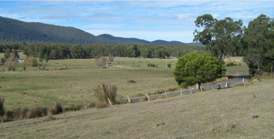
Location: Combienbar
Australian Soil Classification: Bleached-Mottled, Magnesic, Grey DERMOSOL
Map Unit: Combienbar
Previous Site Name: EG218
General Landscape Description: Rolling low hills
Site Description: Upper simple slope, 8% slope, east aspect
Land Use: Grazing
Native Vegetation: Damp forest and lowland forest
Geology: Late Devonian fluvial sediments (conglomerate, sandstone, mudstone)
Soil Profile Morphology:
| Surface soil | 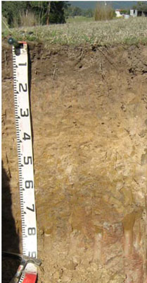 | ||
A1 | 0 – 15 cm | Very dark greyish brown (10YR3/2); very fine sandy loam; weak granular structure; very weak consistence, moist; pH 5.2; clear change to: | |
A2 | 15 – 40 cm | Light brownish grey (10YR6/2) conspicuously bleached with brownish yellow (10YR6/6) mottling increasing with depth; silty loam; apedal; very weak granular structure; weak consistence moist; pH 5.3; sharp change to: | |
Subsoil | |||
B1 | 40 – 60 cm | Greyish brown (10YR5/2) with few medium distinct brown (7.5YR4/4) mottles; silty clay; moderate medium polyhedral structure; very firm consistence moist; pH 5.7; clear change to: | |
B2 | 60 – 90 cm | Greyish brown (10YR5/2) with many coarse distinct reddish brown (5YR4/4) mottles; medium to heavy clay; weak medium polyhedral structure; firm consistence moist; pH 5.6; clear change to: | |
C | 90+ cm | Decomposing rock. |
Key Profile Features:
- Gradual increase in clay content with depth.
Soil Profile Characteristics:
- | pH | Salinity | ||
Surface soil (A1 horizon) | Strongly Acid | Very Low | Non-sodic | None |
Subsoil (B1 horizon) | Moderately Acid | Very Low | Non-sodic | Moderate1 |
Deeper subsoil (60-90 cm) | Moderately Acid | Very Low | Non-sodic | Slight1 |
Chemical and Physical Analysis:
Horizon | Horizon Depth (cm) | pH (water) | pH (CaCl2) | EC dS/m | Organic Carbon % | Total Nitrogen % | Exchangeable Aluminium ppm | Exchangeable Acididty meq/100g | Exchangeable Cations | Coarse Sand (0.2-2.0 mm) % | Fine Sand (0.02-0.2 mm) % | Silt (0.002-0.02 mm) % | Clay (<0.002 mm) % | Field cap. % w/w | Wilt. point % w/w | |||
Ca | Mg | K | Na | |||||||||||||||
meq/100g | ||||||||||||||||||
A1 | 0-15 | 5.2 | 4.2 | <0.05 | 2.6 | 0.14 | 87 | 12.0 | 1.5 | 0.45 | 0.057 | 0.17 | 2 | 54 | 20 | 16 | 28.0 | 6.0 |
A2 | 15-40 | 5.3 | 4.1 | <0.05 | 0.62 | <0.05 | 140 | 6.9 | 0.45 | 0.2 | <0.05 | 0.14 | 2 | 53 | 20 | 20 | 23.1 | 5.4 |
B1 | 40-60 | 5.7 | 3.9 | <0.05 | 0.3 | <0.05 | 580 | 12.0 | 0.24 | 1.7 | 0.055 | 0.49 | 1 | 39 | 24 | 32 | 28.3 | 13.6 |
B2 | 60-90 | 5.6 | 3.9 | <0.05 | 0.38 | <0.05 | 1000 | 15.0 | 0.11 | 4.4 | 0.13 | 1.1 | 0 | 14 | 25 | 57 | 39.5 | 23.5 |
Management Considerations
Whole profile
- There is a gradual increase in clay content down the soil profile until the marked clay horizon at 60 cm.
- The plant available water capacity is considered to be low (estimated at 63 mm) based on an effective rooting depth of 60 cm, which is limited by the clay horizon and, further down, decomposing rock. Because of the low wilting points throughout the profile, plants will be able to use very light rains when the soil is dry. Due to the low water storage capacity of the soil, plants will suffer water stress unless further rains occur.
- The surface soil is strongly acid. This indicates that aluminium toxicity could occur in crops sensitive to aluminium toxicity, eg lucerne. Test strips may be used to determine if lime is economically justified.
- The surface (A1) horizon has a low nutrient holding capacity (based on the sum of the exchangeable calcium, magnesium, potassium and sodium cations).
- Organic matter is important for maintaining soil fertility and water holding capacity.
- Potassium is extremely deficient and a marked response to potassium fertilizer would be expected.
Profile Described By: Ian Sargeant, Heather Adams and Julianne Sargant, June 2009.