Victorian Resources Online (archived)
EGC222
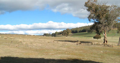
Location: Bendoc
Australian Soil Classification: Acidic, Mesotrophic, Red DERMOSOL
Map Unit: Bendoc (Component 1)
Previous Site Name: EG222
General Landscape Description: Undulating low hills
Site Description: Simple upper slope 5% south west
Land Use: Grazing
Native Vegetation: Montane grassy woodland
Geology: Ordovician sediments
Soil Profile Morphology:
| Surface soil | 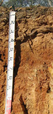 | ||
A1 | 0 – 15 cm | Dark brown (7.5YR3/2); very fine sandy loam; weak fine structure; weak consistence dry; few angular tabular coarse pebbles; pH 5.2; clear change to: | |
A2 | 15 – 40 cm | Brown (7.5YR5/4); very fine sandy clay loam; massive; weak consistence dry; common angular tabular coarse pebbles; pH 5.0; abrupt change to: | |
Subsoil | |||
B2 | 40 – 70 cm | Red (2.5YR4/6); very fine sandy light clay; moderate coarse polyhedral structure; strong consistence moist; abundant angular tabular cobbles ; rock fragments increasing with depth; pH 5.4; diffuse change to: | |
R | 70+ cm | Moderately weathered rock. |
Key Profile Features:
- Gradual increase in clay content with depth.
- Shallow depth to weathering rock.
Soil Profile Characteristics:
- | pH | Salinity | ||
Surface soil (A1 horizon) | Strongly Acid | Very Low | Non-sodic | None |
Subsoil (B1 horizon) | Strongly Acid | Very Low | Non-sodic | None1 |
Deeper subsoil (80-110 cm) | Strongly Acid | Very Low | Non-sodic | None |
Chemical and Physical Analysis:
Horizon | Horizon Depth (cm) | pH (water) | pH (CaCl2) | EC dS/m | Organic Carbon % | Total Nitrogen % | Exch. Al ppm | Exch. Acididty meq/100g | Exchangeable Cations | Coarse Sand (0.2-2.0 mm) % | Fine Sand (0.02-0.2 mm) % | Silt (0.002-0.02 mm) % | Clay (<0.002 mm) % | Field cap. % w/w | Wilt. point % w/w | |||
Ca | Mg | K | Na | |||||||||||||||
meq/100g | ||||||||||||||||||
A1 | 0-10 | 5.2 | 4.5 | 0.09 | 5 | 0.3 | 44 | 13.0 | 3.5 | 1.3 | 0.5 | 0.17 | 14 | 50 | 14 | 10 | 25.6 | 10.6 |
A2 | 10-40 | 5.0 | 4.2 | 0.06 | 1.1 | <0.05 | 160 | 7.9 | 0.47 | 0.31 | 0.3 | 0.19 | 15 | 45 | 11 | 23 | 25.0 | 5.3 |
B2 | 40-60 | 5.4 | 4.6 | 0.06 | 0.44 | <0.05 | 63 | 5.9 | 0.46 | 0.72 | 0.28 | 0.22 | 16 | 47 | 12 | 24 | 30.9 | 7.9 |
Management Considerations
Whole profile
- Plant available water is considered to be low (estimated at 50 mm) for this profile. This is based on an estimated and effective rooting depth of 70 cm (i.e. depth above the decomposing rock) and the presence of decomposing rock within this depth.
- The low wilting points of each horizon to this depth is low (ie 10.6, 5.3 and 7.9 %) indicating plants are able to use light rains when the soil is dry. Due to the low water storage capacity, plants will suffer moisture stress unless further rains occur.
- As mentioned above, the surface soils can hold little water, but plants can use light rains following a dry spell.
- The surface soil is strongly acid. As the exchangeable aluminium is also high a response to lime would be expected. The use of test strips is the most appropriate way of determining the amount of lime needed.
- The nutrient holding capacity of the surface horizons is low (based on the sum of the calcium, magnesium, potassium and sodium cations).
- The organic matter content of the surface soil is high which helps maintain soil fertility and water holding capacity. The soil below 10 cm has a low organic matter content which would explain its low wilting point and very low nutrient holding capacity.
- The potassium is at a moderate level for pastures and no response to added potassium would be expected.
- The increasing amounts of decomposing rock are likely to restrict pasture root development. Those of native plant species are able to follow cracks in the rock and are less restricted.
Profile Described By: Heather Adams, Julieanne Sargant, and Ian Sargeant, June 2009.