Victorian Resources Online (archived)
EGC224
Location: Ambyne
Australian Soil Classification: Haplic, Eutrophic, Red CHROMOSOL
Map Unit: Ambyne (Component 1)
Previous Site Name: EG224
General Landscape Description: Rolling hills
Site Description: Simple upper slope 15% south east
Land Use: Grazing
Native Vegetation: Grassy woodland
Geology: Granite
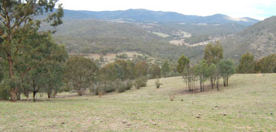
Photo taken about 1.5km north-west of Ambyne Crossing looking south-east along the Deddick River valley
Soil Profile Morphology:
| Surface soil | 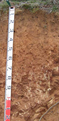 | ||
A11 | 0 – 18 cm | Dark reddish brown (5YR3/3); coarse sandy loam; weak fine granular structure; weak consistence dry; pH 7.2; clear change to: | |
A12 | 18 – 40 cm | Yellowish red (5YR4/6); coarse sandy loam; weak medium polyhedral structure; firm consistence dry; pH 7.3; abrupt change to: | |
| Subsoil | |||
B2 | 40 – 70 cm | Dark red (2.5YR3/6); coarse sandy clay loam; moderate coarse polyhedral structure; strong consistence dry; passing to very weak rock; pH 6.3; diffuse change to: | |
C | 70+ | Weak granitic rock becoming more frequent with depth. |
Key Profile Features:
- Lack of strong texture contrast between the surface (A) and subsoil (B) horizon.
- Shallow depth to decomposing granite.
Soil Profile Characteristics:
- | pH | Salinity | ||
Surface soil (A1 horizon) | Slightly Alkaline | Very Low | Non-sodic | None |
Subsoil (B1 horizon) | Slightly Alkaline | Very Low | Non-sodic | None1 |
Deeper subsoil (80-110 cm) | Slightly Acid | Very Low | Non-sodic | None |
Chemical and Physical Analysis:
Horizon | Horizon Depth (cm) | pH (water) | pH (CaCl2) | EC dS/m | Organic Carbon % | Total Nitrogen % | Exchangeable Aluminium ppm | Exchangeable Acididty meq/100g | Exchangeable Cations | Coarse Sand (0.2-2.0 mm) % | Fine Sand (0.02-0.2 mm) % | Silt (0.002-0.02 mm) % | Clay (<0.002 mm) % | Field Capacity % w/w | Wilting Point % w/w | |||
Ca | Mg | K | Na | |||||||||||||||
meq/100g | ||||||||||||||||||
A1 | 0-18 | 7.2 | 6.3 | <0.05 | 1.1 | <0.05 | <10 | 4.6 | 1.3 | 0.37 | <0.05 | 50 | 25 | 9 | 14 | 18.3 | 4.9 | |
A2 | 18-40 | 7.3 | 6.2 | <0.05 | 0.37 | <0.05 | <10 | 2 | 2 | 0.36 | 0.064 | 47 | 26 | 11 | 15 | 16.6 | 4.6 | |
B2 | 40-70 | 6.3 | 5.0 | <0.05 | 0.35 | <0.05 | 20 | 5.4 | 4.2 | 4.7 | 0.37 | 0.11 | 40 | 20 | 14 | 22 | 22.2 | 9.0 |
Management Considerations
Whole profile
- Plant available water capacity is considered to be low (estimated at 62 mm) for the top 65 cm of the soil profile.
- The low wilting points of each horizon to this depth (4.9, 4.6 and 9.0) indicates plants are able to use light rains when the soil is dry. Due to the low water storage capacity, plants will suffer moisture stress unless further rains occur.
- As mentioned above, the soils surface soils can hold little water, but plants can use light rains following a dry spell.
- The surface soil is slightly alkaline. Here the pH has no adverse implications for plant growth.
- The nutrient holding capacity of the surface horizons is low (based on the sum of the calcium, magnesium, potassium and sodium cations).
- The organic matter content of the surface soil is low. Increasing organic matter will help maintain soil fertility and water holding capacity.
- The potassium is at a moderate level for pastures and no response to added potassium would be expected.
- The slight increase in clay content is unlikely to restrict root penetration of deep rooted species until the decomposing granite is reached at about 70 cm.
Profile Described By: Heather Adams, Julieanne Sargant, and Ian Sargeant, June 2009.