Victorian Resources Online (archived)
EGS247
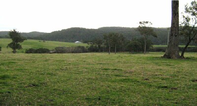
Location: Gipsy Point
Australian Soil Classification: Acidic-Sodic, Dystrophic, Yellow DERMOSOL
Map Unit: Gipsy Point
Previous Site Name: EG247
General Landscape Description: Undulating low hills
Site Description: Crest of a low rise, northern aspect 2% slope
Land Use: Grazing
Native Vegetation: Lowland forest
Geology: Palaeozoic sediments
Soil Profile Morphology:
| Surface soil | 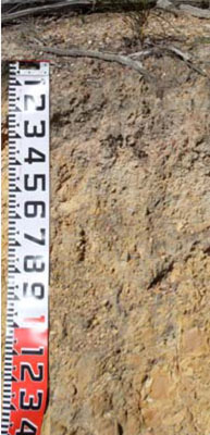 Road exposure nearby on Genoa Road | ||
A1 | 0 – 35 cm | Dark greyish brown (10YR4/2); fine sandy loam; pH 5.1; gradual change to: | |
Subsoil | |||
B1 | 35 – 50 cm | Yellowish brown (10YR5/6); fine sandy clay loam; gradual change to: | |
B2 | 50 – 80 cm | Brownish yellow (10YR6/8); fine sandy light clay; pH 4.3. |
Chemical and Physical Analysis:
Horizon | Horizon Depth (cm) | pH (water) | pH (CaCl2) | EC dS/m | Exchangeable Acididty meq/100g | Exchangeable Cations | |||
Ca | Mg | K | Na | ||||||
meq/100g | |||||||||
A1 | 0-35 | 5.1 | 5.9 | <0.05 | 1.2 | 0.97 | 0.39 | 0.11 | 0.09 |
B2 | 50-70 | 4.3 | 4.4 | <0.05 | 0.9 | 0.6 | 0.98 | 0.02 | 0.15 |
Samples Analysed By: Industry and Investment NSW (2010). Sampled by auger.
Profile Described By: Ian Sargeant, 2011.