Victorian Resources Online (archived)
EGS256
Location: Fernbank
Australian Soil Classification: Eutrophic, Mottled-Subnatric, Brown SODOSOL
Great Soil Group: brown soloth
Map Unit: Fernbank
Previous Site Names: EGG6, EG6
General Landscape Description: Undulating Rises
Site description: North Slope of low rise (4%)
Land Use: Plains grassy woodland
Native Vegetation: Red Gum (E. tereticornis)
Geology: Neogene alluvial sediments
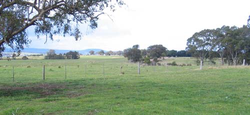
EGS256 Landscape
Soil Profile Morphology:
Surface Soil
| A1 | 0-15 cm | Very dark greyish brown (2.5YR3/2); loamy sand; moderate fine to medium sub-angular blocky structure; very weak consistence moderately moist; pH 5.7; clear and smooth change to: | 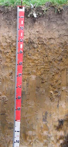 EGS256 Profile |
| A2 | 15-27 cm | Pale brown (10YR6/3), light grey (10YR7/2) dry; sand; massive, loose to very weak consistence moist; very few fine quartz gravel; pH 6.0; abrupt and wavy change to: | |
| Subsoil | |||
| B21 | 27-90 cm | Yellowish brown (10YR5/4) with many coarse distinct strong brown (5YR5/8) mottles; heavy clay; weak very coarse columnar structure parting to moderate medium; to coarse prismatic structure; firm consistence moist; pH 6.6; diffuse change to: | |
| B22 | 90-120 cm | Yellowish brown (10YR5/4) with common medium distinct grey and red mottles; heavy clay; weak medium prismatic structure; very firm consistence moderately moist; pH 7.2. |
Key Profile Features:
- Strong texture contrast between the surface horizons (A1 and A2) and the subsoils (B horizons).
- Conspicuously bleached subsurface (A2) horizon.
pH | Sodicity | ||
Surface (A1 horizon) | Moderately Acidic | Non Sodic | None |
Subsoil (B21 horizon) | Slightly Acidic | Sodic | Strong |
Deep Subsoil 90 – 120 cm | Moderately Alkaline | Strongly Sodic | Moderate |
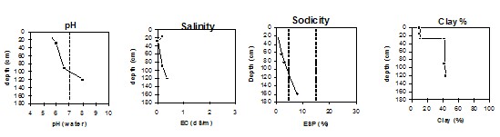
Chemical and Physical Analysis:
Horizon | Horizon Depth (cm) | pH (water) | pH (CaCl2) | EC dS/m | Organic Carbon % | Total Nitrogen % | Exchangeable Acididty meq/100g | Exchangeable Cations | Coarse Sand (0.2-2.0 mm) % | Fine Sand (0.02-0.2 mm) % | Silt (0.002-0.02 mm) % | Clay (<0.002 mm) % | Field Capacity % w/w | Wilting Point % w/w | |||
Ca | Mg | K | Na | ||||||||||||||
meq/100g | |||||||||||||||||
A1 | 0-15 | 5.7 | 4.5 | 0.19 | 3.6 | 0.36 | 12 | 4.6 | 1.3 | 0.81 | 0.44 | 37 | 39 | 7 | 10 | 20.4 | 6.9 |
A2 | 15-27 | 6.0 | 4.5 | <0.05 | 4.3 | 0.85 | 0.36 | 0.24 | 0.11 | 39 | 43 | 7 | 11 | 11.3 | 1.8 | ||
B21 | 27-90 | 6.6 | 6.4 | 0.19 | 4.9 | 1.7 | 8.2 | 0.62 | 1.8 | 20 | 27 | 9 | 42 | 26.9 | 15.3 | ||
B22 | 90-120 | 8.0 | 7.2 | 0.35 | 0.5 | 8.7 | 0.3 | 2.8 | 18 | 26 | 11 | 43 | 23.4 | 13.0 | |||
Management Considerations
Whole profile
- Plant available water is considered to be very low (estimated at 47 mm) for this profile based on an effective rooting depth of 35 mm. The dense and coarsely structured upper subsoil is likely to restrict root depth. Most of the plant available water will be in the A1 horizon as the A2 horizon will be seasonally saturated. Roots in the subsoil will be confined to cracks in the soil and not penetrate deeply.
Surface (A) horizons
- The surface soil is moderately acid but is highly unlikely to affect plant growth.
- Potassium levels are high and no response to added potassium is likely.
- The surface (A1) horizon has a low nutrient holding capacity. Organic matter is important for maintaining nutrient and water holding capacity, especially in sandy soils
- The low wilting points of the surface soils indicates plants will be able to use very light rains when the soil is dry. Due to the low water storage capacity of the surface soils, plants will soon suffer moisture stress unless follow-up rains occur.
Subsoil (B) horizons
- The dense and coarsely structured subsoil is sodic and is strongly dispersive. This will result in significantly restricted root and water movement. The use of gypsum in association with deep ripping has been advocated by some researchers as an effective way to ameliorate sodic subsoils.
Profile Described By: Ian Sargeant, 2001.