Victorian Resources Online (archived)
EGS259
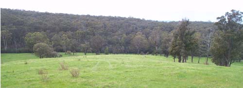
Location: Glenaladale
Australian Soil Classification: Bleached, Mesotrophic, Red KUROSOL
Map Unit: Glenaladale (Component 1)
Previous Site Name: EG259
General Landscape Description: Rolling to steep low hills.
Site description: Mid-slope, Northly aspect, 20% slope
Land Use: Grazing
Native Vegetation: Shrubby dry forest
Geology: Late Devonian freshwater sediments
Soil Profile Morphology:
Surface Soil
| A1 | 0 – 10 cm | Dark brown (7.5YR3/2); very fine sandy clay loam; moderate fine (<20 mm) subangular blocky structure; very few (<2%) angular pebbles (6-20 mm); clear change to: | 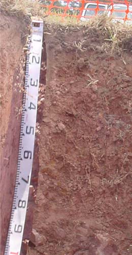 EG259 Profile |
| A2 | 10 - 30 cm | Reddish brown (5YR4/3); conspicuously bleached pinkish grey (5YR6/2d); fine sandy clay loam; moderate very coarse structure; strong consistence dry; clear change to: | |
| Subsoil | |||
| B2 | 30 - 50 cm | Reddish brown (5YR4/4); light medium clay; weak coarse (50-100 mm) prismatic structure; parting to strong medium to fine angular blocky; strong consistence dry; gradual change to: | |
| C | 50 -100 cm | Reddish brown (5YR4/4); light medium clay; strong medium subangular blocky structure; few (2-10%) angular shale cobbles increasing with depth passing to: | |
| R | 100+ cm | Decomposing red shale |
Key Profile Features:
- Weak colour contrast between the surface (A) horizons and the subsoil (B) horizons.
- Red colours throughout the soil profile.
- Strong medium to fine structure in the B horizon which facilitates root development.
Soil Profile Characteristics:
pH | |||
Surface soil (A horizon) | 5.0 | Non-sodic | None |
Subsoil (B2 horizon) | 5.3 | Non-sodic | Slight1 |
Deep subsoil (C horizon) | 5.6 | Non-sodic | Strong |
Chemical and Physical Analysis:
Horizon | Horizon Depth (cm) | pH (water) | pH CaCl2 | EC dS/m | Organic Carbon % | Total Nitrogen % | Exchangeable Aluminium ppm | Exchangeable Acididty meq/100g | Exchangeable Cations | Coarse Sand (0.2-2.0 mm) % | Fine Sand (0.02-0.2 mm) % | Silt (0.002-0.02 mm) % | Clay (<0.002 mm) % | Field Capacity % w/w | Wilting Point % w/w | |||
Ca | Mg | K | Na | |||||||||||||||
meq/100g | ||||||||||||||||||
A1 | 0-10 | 5.0 | 4.4 | 0.08 | 5.5 | 0.33 | 130 | 16 | 2.9 | 1.2 | 0.2 | 0.2 | 22 | 29 | 25 | 13 | 28.7 | 11.5 |
A2 | 10-30 | 5.2 | 4.3 | <0.05 | 1.1 | 0.06 | 120 | 9.1 | 1.0 | 0.9 | <0.1 | <0.1 | 15 | 31 | 31 | 19 | 22.5 | 8.8 |
B2 | 30-50 | 5.3 | 4.2 | <0.05 | 270 | 11 | 0.5 | 2.5 | 0.1 | 0.1 | 4 | 14 | 32 | 48 | 30.8 | 17.9 | ||
C | 50-100 | 5.6 | 4.4 | 0.08 | 140 | 8.4 | <0.1 | 4.4 | 0.1 | 0.6 | 2 | 12 | 32 | 55 | 33.8 | 19.9 | ||
Management Considerations
Whole profile
- There is a marked increase in soil texture down the soil profile.
- Bleached A2 horizon when dry (does not show on a moist pit face shown here).
- The plant available water capacity is considered to be moderate (estimated at 75 mm) based on an effective rooting depth of 80 cm, which is slightly limited by the presence of stone in the profile.
- Exchangeable aluminium levels are high and likely to affect aluminium sensitive species.
Surface (A) horizons
- The surface soil is strongly acid. This indicates aluminium toxicity could occur in crops sensitive to aluminium toxicity, eg lucerne. Test strips may be used to determine if lime is economically justified.
- The surface (A1) horizon has a low nutrient holding capacity (based on the sum of the exchangeable calcium, magnesium, potassium and sodium cations). Organic matter is important for maintaining soil fertility, water holding capacity.
- Potassium is deficient and a response to potassium fertiliser would be expected.
- Even though the soil has a marked increase in clay content between the A2 and B21 horizons, it does not appear to have affected root penetration. This has resulted in the soil’s moderate ability to retain water.
Subsoil (B) horizons
- The subsoil is non-sodic and has a strong medium to fine angular blocky structure which allows good root penetration.
- Although the deeper subsoil is non-sodic, slakes partially and completely disperses when wet for 20 hours. Such soils may be prone to tunnel and gully erosion, particularly where subsoil water accumulates, for example in gullies.
Profile Described By: Ian Sargeant, 2001.