Victorian Resources Online (archived)
EGS264
Location: Wiseleigh
Australian Soil Classification: Melacic, Magnesic (and Dystrophic), Brown CHROMOSOL
Map Unit: Tambo (Component 2)
Previous Site Name: EG264
General Landscape Description: Gently undulating plain.
Site Description: Mid south slope, 17% slope
Land Use: Grazing
Native Vegetation: Grassy woodland
Geology: Ordovician sediments
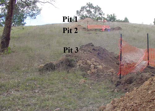
Sequence of soil pits examined at Wiseleigh
Soil Profile Morphology:
Surface Soil
| A11 | 0 – 8 cm | Very dark grey (7.5YR3/1); loam; strong fine granulars structure; firm consistence dry; abrupt change to: | 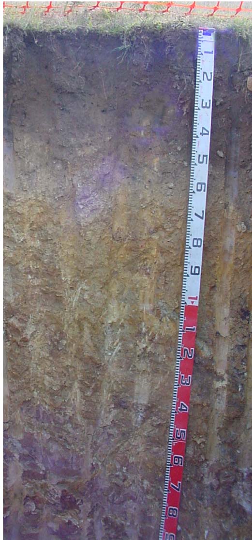 EG264 Profile |
| A12 | 8 – 35 cm | Very dark grey (7.5YR3/1); clay loam; weak fine angular blocky structure; firm consistence dry ; clear change to: | |
| Subsoil | |||
| B21 | 35 – 50 cm | Brown (7.5YR5/4) medium clay; moderate coarse (50 -100 mm) prismatic structure; firm consistence dry; few (2 – 10%) angular pebbles (< 60 mm); gradual change to: | |
| B22 | 50 – 70 cm | Light brown (7.5YR6/4); light clay; moderate coarse (50 - 100 mm) prismatic structure; very firm consistence dry; few (2 – 10%) angular pebbles (< 60 mm); gradual change to: | |
| C | 70 – 100 cm | Mottled yellow (10YR7/6) and reddish yellow (5YR6/6); light clay; strong medium (10 – 20 mm) polyhedralstructure; very firm consistence dry; diffuse change to: | |
| R | 100 cm+ | Weak decomposing rock |
Key Profile Features:
- Texture contrast between the surface (A) horizons and the subsoil (B horizons).
- Very high organic matter in the surface soil, which enhances nutrient and water-holding capacity.
Soil Profile Characteristics:
| Sodicity | |||
Surface soil (A11) | Very strongly acid | Non-sodic | - |
Subsoil (B21 horizon) | Moderately acid | Non-sodic | None |
Deep subsoil (C horizon) | Slightly acid | Sodic | Slight1 |
Chemical and Physical Analysis:
Horizon | Horizon Depth (cm) | pH (water) | pH CaCl2 | CE dS/m | Organic Carbon % | Total Nitrogen % | Exch. Al | Exch. Acididty meq/100g | Exchangeable Cations | Coarse Sand (0.2-2.0 mm) % | Fine Sand (0.02-0.2 mm) % | Silt (0.002-0.02 mm) % | Clay (<0.002 mm) % | Field cap. % w/w | Wilt. point % w/w | |||
Ca | Mg | K | Na | |||||||||||||||
meq/100g | ||||||||||||||||||
A11 | 0-8 | 4.9 | 4.2 | 0.12 | 11 | 0.59 | 360 | 18 | 3.4 | 3.2 | 0.9 | 0.1 | 24 | 23 | 19 | 19 | 53.1 | 30 |
A12 | 8-35 | 5.0 | 4.3 | <0.05 | 5.3 | 0.22 | 460 | 20 | 0.2 | 0.7 | 0.2 | .1 | 17 | 24 | 23 | 28 | 53.0 | 15.2 |
B21 | 35-50 | 5.8 | 4.7 | <0.05 | 140 | 13 | <0.1 | 0.7 | 0.2 | 0.1 | 18 | 22 | 13 | 44 | 34.4 | 14.1 | ||
B22 | 50-70 | 5.8 | 4.7 | <0.05 | 82 | 6.1 | <0.1 | 0.7 | 0.1 | <0.1 | 22 | 21 | 27 | 28 | 29.3 | 12.4 | ||
C | 70-100 | 6 | 4.6 | <0.05 | 55 | 4.2 | <0.1 | 1.3 | 0.2 | 0.2 | 8 | 16 | 46 | 29 | 35.5 | 14.7 | ||
Management Considerations
Whole profile
- Based on a plant root depth of 50 cm, the plant available water capacity is about 62 mm.
- Texture contrast between the surface (A horizons) and the subsoil (B horizon).
Surface (A) horizons
- The surface (A11) horizon has a particularly high organic matter content which has greatly added to the nutrient holding and water holding capacity of the soil. By contrast the subsurface soil (A12) horizon has a very low nutrient holding capacity.
- The surface soil is very strongly acidic and the very high levels of exchangeable aluminium are likely to restrict the growth of aluminium sensitive species. A response to lime would be expected, but before it is applied, test strips should be used to evaluate the cost/benefit.
Subsoil (B and C) horizons
- All of these horizons have a very low nutrient holding capacity (based on the sum of the calcium, magnesium, potassium and sodium cations).
- The deep subsoil (C horizon) is sodic and shows moderate dispersion after 20 hours of wetting. Such a soil would be prone to tunnel and gully erosion.
Profile Described By: Ian Sargeant (2011).