Victorian Resources Online (archived)
EGW18
Location: Jarramond
Australian Soil Classification: Eutrophic, Mesonatric, Brown SODOSOL Brown sodic texture contrast soil (thick loamy)
Map Unit: River terrace (Component 5)
Previous Site Name: EG18
General Landscape Description: Undulating rises
Site description: Road reserve, Upper slope, NNE aspect 8% slope
Land Use: Grazing
Geology: Pleistocene alluvial sediments (Qp5)
Soil Profile Morphology:
| Surface soil | 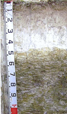 Profile similar to that described | ||
A1 | 0 – 35 cm | Very dark grey (10YR3/1); fine sandy loam; moderate medium polyhedral structure; very weak consistence moist; clear change to: | |
A2 | 35 – 50 cm | Greyish brown (10YR5/2) conspicuously bleached (10YR7/2d); loamy fine sand; apedal; firm consistence dry; sharp change to: | |
Subsoil | |||
B21 | 50 – 100 cm | Brown (10YR5/3) mottled with black (10YR2/1); heavy clay; moderate coarse prismatic structure; strong consistence moderately moist. |
Key Profile Features:
- Deep fine sandy surface soil
- Very strong texture contrast between the deep surface soils (A) horizons and the more clayey subsoil (B) horizon.
Soil Profile Characteristics:
- | pH | Salinity | ||
Surface soil (A1 horizon) | Strongly acid | Very low | Non sodic | None |
Subsoil (A2 horizon) | Slightly acid | Very low | Non sodic | Strong1 |
Deeper subsoil (50-100 cm) | Moderately acid | Low | Sodic | Strong1 |
Chemical and Physical Analysis:
Horizon | Horizon Depth (cm) | pH (water) | pH (CaCl2) | EC dS/m | Organic Carbon % | Total Nitrogen % | Exchangeable Aluminum ppm | Exchangeable Acididty meq/100g | Exchangeable Cations | Coarse Sand (0.2-2.0 mm) % | Fine Sand (0.02-0.2 mm) % | Silt (0.002-0.02 mm) % | Clay (<0.002 mm) % | Field Capacity % w/w | Wilting Point % w/w | |||
Ca | Mg | K | Na | |||||||||||||||
meq/100g | ||||||||||||||||||
A1 | 0-35 | 5.3 | 4.5 | 0.08 | 2.4 | 0.18 | 26 | 12 | 2.4 | 1.6 | 0.35 | 0.23 | 5 | 58 | 19 | 13 | 25.4 | 8.0 |
A2 | 35-50 | 6.1 | 5.0 | 0.05 | <10 | 3.7 | 0.76 | 0.91 | 0.17 | 0.32 | 5 | 66 | 20 | 9 | ||||
B2 | 50-100 | 5.9 | 4.9 | 0.23 | 18 | 11.0 | 1.1 | 6.9 | 0.92 | 2.5 | 2 | 37 | 13 | 47 | ||||
Management Considerations
Surface (A) Horizons
- The surface soil is strongly acid, but is unlikely to show any response to lime.
- As the surface soils have high fine sand and silt and low clay content they tend to set when wet following cultivation and subsequent irrigation unless the organic matter is maintained.
- The surface horizons have very low inherent fertility (based on the sum of the exchangeable cations).
- The surface soil is quite high in potassium and no response to potassium fertilisers would be expected.
Subsoil (B) Horizon
- Because of the marked texture contrast between the surface soils and the sodic and dispersive subsoil, downward water movement is likely to be impeded, resulting in water table problems after prolonged periods of rain.
- The level of soluble salts is slightly higher than normal, but unlikely to cause problems as the surface soil is deep.
- The sodic nature of the subsoil is unlikely to directly affect plants as is it too deep. However water table problems may occur after rain.
Profile Described By: David Rees and Grant Boyle, 2000.