Victorian Resources Online (archived)
EGW25
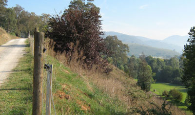
Location: Buchan
Australian Soil Classification: Haplic, Calcic, Brown DERMOSOL
Map Unit: Taravale (Component 1)
Previous Site Name: EG25
General Landscape Description: Steep hills
Site description: Mid slope, NE aspect, 27% slope
Land Use: Road reserve
Native Vegetation: Grassy woodland
Geology: Devonian limestone
Soil Profile Morphology:
| Surface soil | 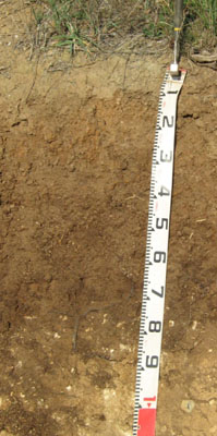 | ||
| A | 0 – 25 cm | Very dark brown (7.5YR4/2); clay loam (sub plastic); strong medium polyhedral structure; moderate amount (20-50%) subangular limestone pebbles (6 – 20 mm); clear change to: | |
| Subsoil | |||
| B | 25 – 65 cm | Dark brown (7.5YR4/3); heavy clay; strong medium prismatic parting to fine prismatic structure; common (10-20%) subangular limestone pebbles (6 – 20 mm; abrupt change to: | |
| C | 65– 85+ cm | Light yellowish brown (10YR6/4) rubbly limestone. |
*As the roadside cutting did not have a vertical slope the measurements on the tape will not show the true vertical depth
.
Key Profile Features:
- High clay content throughout.
- Strongly structured and deep soil.
Soil Profile Characteristics:
| - | pH | Salinity | Sodicity | |
Surface soil (A horizon) | Moderately acid | Very low | Non sodic | None |
Subsoil (B horizon) | Slightly acid | Very low | Non sodic | None |
Chemical and Physical Analysis:
Horizon | Horizon Depth (cm) | pH (water) | pH (CaCl2) | EC dS/m | Organic Carbon % | Total Nitrogen % | Exchangeable Acididty meq/100g | Exchangeable Cations | Coarse Sand (0.2-2.0 mm) % | Fine Sand (0.02-0.2 mm) % | Silt (0.002-0.02 mm) % | Clay (<0.002 mm) % | Field Capacity % w/w | Wilting Point % w/w | |||
Ca | Mg | K | Na | ||||||||||||||
meq/100g | |||||||||||||||||
A | 0-25 | 5.9 | 5.3 | 0.1 | 2.3 | 0.18 | 9.1 | 11 | 1.4 | 0.72 | 0.17 | 12 | 19 | 26 | 40 | 33.8 | 16.6 |
B | 25-65 | 6.7 | 5.9 | 0.1 | 9.4 | 19 | 2.2 | 0.71 | 0.27 | 2 | 6 | 11 | 78 | 40.9 | 25.3 | ||
Management Considerations
- Plant available water (PAW) here is considered to be high, estimated to be 115 mm. Because of the variability in the depth of soil cover within this map unit, many soils will have low to very low water-holding capacity. Effective rooting depth is limited by the depth to rock.
Surface (A) horizons
- The surface soil here is moderately acid. However because the soil has limestone in the subsoil, no response to additional lime would be anticipated.
- The soil is low in soluble salts.
- Potassium levels are high and plant responses to potassium fertiliser are unlikely.
- The nutrient holding capacity of the surface A horizon is high (based on the sum of the exchangeable calcium, magnesium, potassium and sodium cations).
Subsoil (B) horizons
- The subsoil would be relatively well drained and strongly structured which will enable plant roots to penetrate easily until they reach rock.
Profile Described By: David Rees and Grant Boyle, 2000.