Victorian Resources Online (archived)
EGW83
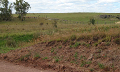
Location: Wulgulmerang
Australian Soil Classification: Haplic, Eutrophic, Brown CHROMOSOL (Stony)
Map Unit: Gelantipy (Component 1)
Previous Site Name: EG83
General Landscape Description: Plateau
Site Description: Lower slope, <2% slope (Roadside exposure)
Land Use: Grazing
Native Vegetation: Montane grassy woodland
Geology: Tertiary basalt
Soil Profile Morphology:
| Surface soil | 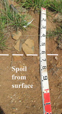 | ||
| A1 | 0 – 30 cm | Brown (7.5YR3/2); silty clay loam; strong coarse polyhedral structure; firm consistence moderately moist; many subrounded basalt stones; pH 6.3; clear change to: | |
| Subsoil | |||
| B2 | 30 - 55+cm | Brown (7.5YR4/2); medium clay; moderate to strong medium prismatic structure; very firm consistence moderately moist; abundant subrounded basalt stones; pH 6.7. |
Key Profile Features:
- Moderate texture contrast between the surface and subsoil horizons.
- Basalt stones throughout the profile, although other roadside cuttings show this to be a variable feature.
Soil Profile Characteristics:
| - | pH | Salinity | ||
Surface soil (A1 horizon) | Slightly acid | Very low | Non sodic | None |
Subsoil (B2 horizon) | Slightly acid | Very low | Non sodic | None |
Chemical and Physical Analysis:
Horizon | Horizon Depth (cm) | pH (water) | pH (CaCl2) | EC dS/m | Organic Carbon % | Total Nitrogen % | Free Fe2O3 % w/w | Exchangeable Aluminium ppm | Exchangeable Acididty meq/100g | Exchangeable Cations | Coarse Sand (0.2-2.0 mm) % | Fine Sand (0.02-0.2 mm) % | Silt (0.002-0.02 mm) % | Clay (<0.002 mm) % | Field Capacity % w/w | Wilting Point % w/w | |||
Ca | Mg | K | Na | ||||||||||||||||
meq/100g | |||||||||||||||||||
A1 | 0-30 | 6.3 | 5.7 | 0.06 | 2.3 | 0.2 | 2.1 | <1 | 9.2 | 11 | 6.4 | 0.34 | 0.29 | 11 | 34 | 26 | 25 | 41 | 17.9 |
B2 | 30-55 | 6.7 | 5.9 | 0.11 | 2.4 | 10.0 | 17 | 13 | 0.35 | 0.29 | 5 | 26 | 21 | 42 | 47.9 | 29.3 | |||
Management Considerations
Whole profile
- The profile is slightly acid throughout.
- These soils are well drained due their strongly developed structure.
- Plant available water capacity is considered to be low, estimated at 45 mm based on the laboratory data, and taking into consideration the presence of basalt stones.
Surface (A) horizons
- The soil has low organic matter content. Organic matter will be better maintained under rotational grazing, which enables stronger pasture recovery, rather than set stocking.
- The nutrient holding capacity of the soil is high (based on the sum of the exchangeable basic cations).
- Potassium levels are low to moderate.
Subsoil (B) horizon
- The friable nature of the subsoil allows deep penetration of plant roots until the basalt rock is encountered.
- The friable nature of the subsoil and the presence of rock will lead to problems with sealing of earth dams.
Profile Described By: David Rees and Grant Boyle, 2000.