Victorian Resources Online (archived)
EGW87c
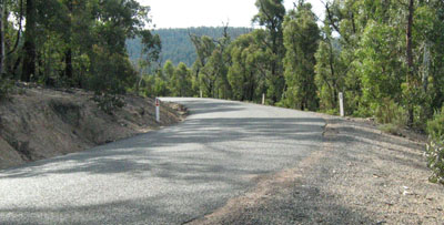
Location: Seldom Seen
Australian Soil Classification: Bleached, Dystrophic, Grey KANDOSOL
Map Unit: Carrabungla
Previous Site Name: EG87c
General Landscape Description: Steep hills
Site Description: Upper slope, NE aspect, 21 % slope
Land Use: Native forest
Geology: Devonian Volcanics (Snowy River Volcanics)
Soil Profile Morphology:
| Surface soil | 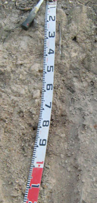 | ||
| A1 | 0 – 5 cm | Grey (7.5YR6/1); silty loam; weak subangular blocky structure, weak consistence dry; few subangular gravel fragments; clear change to: | |
| A21 | 5 – 20 cm | Pinkish grey (7.5YR7/2;) conspicuously bleached (5YR8/1d) silty loam; massive, firm consistence moderately moist; few subangular gravel fragments; pH 5.1; gradual change to: | |
| A22 | 20 – 45cm | Pinkish grey (7.5YR7/2); silty loam; massive structure, firm consistence moderately moist; few subangular gravel fragments; pH 4.9; clear change to: | |
| Subsoil | |||
| B2 | 45 – 75+ cm | Mottled pinkish grey (7.5YR7/3) and pinkish white (7.5YR7/3) silty clay loam; weak coarse prismatic structure, firm consistence moderately moist common subangular gravel fragments; pH 5.4. |
Key Profile Features:
- Lack of strong texture contrast between the surface soils (A1, A21 and A22) horizons and the subsoil (B) horizon.
Soil Profile Characteristics:
| - | pH | Salinity | ||
Surface soil (A1 horizon) | Strongly acid | Very low | Non sodic | None1 |
Subsoil (B2 horizon) | Strongly acid | Very low | Non sodic | None |
Chemical and Physical Analysis:
Horizon | Horizon Depth (cm) | pH (water) | pH (CaCl2) | EC dS/m | Organic Carbon % | Total Nitrogen % | Exchangeable Aluminium ppm | Exchangeable Acididty meq/100g | Exchangeable Cations | Coarse Sand (0.2-2.0 mm) % | Fine Sand (0.02-0.2 mm) % | Silt (0.002-0.02 mm) % | Clay (<0.002 mm) % | Field Capacity % w/w | Wilting Point % w/w | |||
Ca | Mg | K | Na | |||||||||||||||
meq/100g | ||||||||||||||||||
A21 | 5-20 | 5.1 | 4.7 | <0.05 | 3.5 | 0.11 | 330 | 7.4 | 0.37 | 0.67 | 0.28 | 0.08 | 16 | 22 | 43 | 18 | 25.8 | 8.3 |
A22 | 20-45 | 4.9 | 4.5 | <0.05 | 320 | 9.3 | 0.49 | 0.35 | 0.27 | 0.10 | 19 | 23 | 44 | 12 | 27.6 | 6.0 | ||
B2 | 45-75 | 5.4 | 4.5 | <0.05 | 270 | 6.2 | 0.13 | 0.9 | 0.32 | 0.11 | 20 | 23 | 37 | 20 | 25.8 | 10.5 | ||
Management Considerations
Whole profile
- The profile is strongly acid throughout.
- The level of exchangeable aluminium measured for this site is quite high (330 ppm). The growth of aluminium sensitive species, such as lucerne, may be restricted. Aluminium and manganese toxicity may occur.
- There should be likely long term benefits of applying lime, preferably incorporated, on this site if the test results are representative of the paddock. A pH/aluminium test is, however, best performed from samples taken across the paddock and bulked together.
- Before lime is recommended other factors need to be considered including pasture species grown, method of application, local trial responses, soil surface structure and likely cost/benefit.
- If the soil was under pasture with an effective rooting depth of 75 cm the plant available water capacity is considered to be low; estimated at 54 mm.
Surface (A1 and A21) horizons
- The soil has a reasonable organic matter content.
- The low wilting point of the surface horizons indicates if pasture species are grown, they will be able to use light rains when the soil is dry. Due to the low water storage capacity of the soil, plants will suffer water stress unless further rains occur.
- The soils are strongly acidic and, if under pasture, would show a marked response to lime.
- The nutrient holding capacity of the soil is very low (based on the sum of the exchangeable basic cations).
- Potassium levels are deficient and a response to potassium fertilisers would be expected if the soils were under pasture.