Victorian Resources Online (archived)
EGW87w
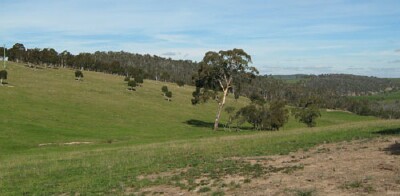
Location: Wulgulmerang
Australian Soil Classification: Bleached, Magnesic, Grey KUROSOL
Map Unit: Wulgulmerang (Component 1)
Previous Site Name: EG87w
General Landscape Description: Rolling hills
Site Description: Upper slope, ENE aspect, 10 % slope
Land Use: Grazing
Geology: Devonian acid volcanics (Snowy River Volcanics)
Soil Profile Morphology:
| Surface soil | 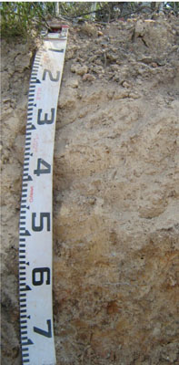 | ||
| A1 | 0 – 5 cm | Dark greyish brown (10YR4/2); loam; weak crumb structure; very weak consistence dry; pH 5.2; clear change to: | |
| A21 | 5 – 30 cm | Pale brown (10YR6/3) conspicuously bleached (7.5YR8/2d); silty loam; massive; firm consistence dry; few subangular gravel fragments; pH 5.0; gradual transition to: | |
| A22 | 30 – 60 cm | Very pale brown (10YR7/4); silty loam; massive; very firm consistence moderately moist; many subangular fine to coarse gravel fragments; pH 5.0 clear change to: | |
| Subsoil | |||
| B2 | 60 – 90+ cm | Distinctly mottled pale brown (10YR6/3) and red (2.5YR5/6); medium clay; moderate to strong coarse polyhedral structure; very firm consistence moderately moist; pH 5.2. |
Key Profile Features:
- Strong texture contrast between the surface (A1, A21 and A22) horizons and the subsoil (B2) horizon.
- Conspicuously bleached subsurface (A21 and A22) horizons that are hard setting.
Soil Profile Characteristics:
- | pH | Salinity | ||
Surface soil (A1 horizon) | Strongly Acid | Very Low | Non-sodic | None |
Subsoil (A21 horizon) | Strongly Acid | Very Low | Non-sodic | None |
Deep subsoil (B2 horizon) | Strongly Acid | Very Low | Non-sodic | None |
Chemical and Physical Analysis:
Horizon | Horizon Depth (cm) | pH (water) | pH (CaCl2) | EC dS/m | Organic Carbon % | Total Nitrogen % | Exchangeable Aluminium ppm | Exchangeable Acididty meq/100g | Exchangeable Cations | Coarse Sand (0.2-2.0 mm) % | Fine Sand (0.02-0.2 mm) % | Silt (0.002-0.02 mm) % | Clay (<0.002 mm) % | Field Capacity % w/w | Wilting Point % w/w | |||
Ca | Mg | K | Na | |||||||||||||||
meq/100g | ||||||||||||||||||
A1 | 0-5 | 5.2 | 4.5 | <0.05 | 3.5 | 0.11 | 58 | 9.7 | 2.0 | 0.79 | 0.42 | 0.07 | 31 | 36 | 20 | 9 | 22.0 | 5.6 |
A21 | 5-30 | 5.0 | 4.3 | <0.05 | 140 | 5.6 | 0.21 | 0.24 | 0.25 | <0.05 | 28 | 32 | 28 | 11 | 19.6 | 5.5 | ||
A22 | 30-60 | 5.0 | 4.3 | <0.05 | 160 | 5.3 | 0.13 | 0.34 | 0.23 | 0.07 | 34 | 23 | 26 | 17 | 19.4 | 6.8 | ||
B2 | 60-90 | 5.2 | 4.1 | <0.05 | 640 | 13.0 | 0.1 | 1.5 | 0.41 | 0.22 | 23 | 9 | 11 | 57 | 37.7 | 21.9 | ||
Management Considerations
Whole profile
- The profile is strongly acid throughout.
- After prolonged periods of rain, the soil horizons above the subsoil clay could become water-logged.
- Plant available water capacity is considered to be low to moderate estimated at 67 mm. This is based on the laboratory data, and a rooting depth of 80 cm.
- Exchangeable aluminium levels are high, which means that the soil is not suited to aluminium-sensitive crops such as lucerne.
- The soil has moderate organic matter content, estimated at 6%.
- The low wilting point of the surface horizons indicates that plants will be able to use light rains when the soil is dry. Due to the low water storage capacity of the soil, plants will suffer water stress unless further rains occur.
- The pH is strongly acidic and a strong response to lime would be expected. Before lime is applied further tests, e.g. laboratory tests and lime test strips, are recommended to determine a likely cost/benefit. In strongly acid soils deficiencies in molybdenum and phosphorus may occur.
- The nutrient holding capacity of the soil is low (based on the sum of the exchangeable basic cations).
- Potassium levels are moderate, bordering on deficient , so no marked response to potassium fertilisers would be expected.
- The subsoil has very low inherent fertility
- As the subsoil has extremely high exchangeable aluminium content root development of aluminium-sensitive species into this zone will be restricted.
Profile Described By: David Rees and Grant Boyle, 2000.