Victorian Resources Online (archived)
EGW9
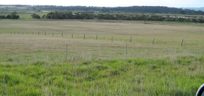
Location: Orbost River flats
Australian Soil Classification: Melanic, Eutrophic, Black DERMOSOL
Map Unit: River flats (rf)
Previous Site Name: EG9
General Landscape Description: Alluvial plain
Site Description: Level plain >1% slope
Land Use: Grazing
Native Vegetation: Riparian forest
Geology: Recent sediments
Soil Profile Morphology:
| Surface Soil | 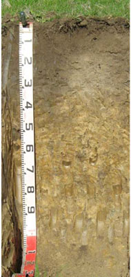 | ||
A11 | 0 – 25 cm | Very dark grey (10YR3/1); clay loam; strong medium polyhedral structure, weak consistence moist; pH 5.9 clear change to: | |
A12 | 25 – 55 cm | Black (10YR2/1); clay loam; moderate medium polyhedral structure; firm consistence moist; pH 6.3; changes to: | |
| A13 | 55 - 70 cm | Clay loam; pH 6.4; changes to: | |
Deep Subsoil | |||
D | 70 – 105 cm | Very dark grey (10YR3/1); clay loam; weak to very weak coarse prismatic structure; firm consistence moist; pH 6.7. |
Key Profile Features:
- Lack of texture contrast throughout the soil profile.
Soil Profile Characteristics:
- | pH | Salinity | ||
Surface Soil (A11 horizon) | Moderately Acid | Very Low | Non Sodic | None |
Subsoil (50-57 cm) | Slightly Acid | Very Low | Non Sodic | None1 |
Deeper Subsoil (70 -105 cm) | Slightly Acid | Very Low | Non Sodic | None2 |
Chemical and Physical Analysis:
Horizon | Horizon Depth (cm) | pH (water) | pH (CaCl2) | EC dS/m | Organic Carbon % | Total Nitrogen % | Exchangeable Aluminium ppm | Exchangeable Acididty meq/100g | Exchangeable Cations | Coarse Sand (0.2-2.0 mm) % | Fine Sand (0.02-0.2 mm) % | Silt (0.002-0.02 mm) % | Clay (<0.002 mm) % | Field Capacity % w/w | Wilting Point % w/w | |||
Ca | Mg | K | Na | |||||||||||||||
meq/100g | ||||||||||||||||||
A11 | 0-25 | 5.9 | 5.0 | 0.12 | 2.8 | 0.25 | <10 | 14 | 7.6 | 6.4 | 0.84 | 0.96 | 1 | 28 | 30 | 35 | 40.6 | 23.3 |
A12 | 25-55 | 6.3 | 5.3 | 0.07 | 2.5 | 0.19 | <10 | 14 | 10.0 | 7.1 | 0.22 | 0.63 | 1 | 27 | 33 | 29 | ||
A13 | 55-70 | 6.4 | 5.4 | 0.08 | 2.2 | 0.14 | <10 | 13 | 8.8 | 7.9 | 0.19 | 0.78 | 2 | 28 | 33 | 29 | ||
D | 70-105 | 6.7 | 5.5 | 0.07 | <10 | 9.5 | 6.9 | 8.3 | 0.15 | 0.84 | 1 | 34 | 31 | 29 | ||||
Management Considerations
Whole Profile
- There are no impeding layers in the profile which allows plant roots deep penetration.
Surface (A11) Horizon
- The relatively deep surface soil is moderately well structured and is friable when moist. Soil consistence when moist is also weak for this horizon. As a result of these attributes the surface soil will provide excellent seed germination conditions and few other limitations to root and water movement.
- The nutrient holding capacity of this soil is high (based on the sum of the exchangeable calcium, magnesium and potassium cations)
- Potassium levels are high and no response to potassium fertilizer would be expected. However below 25 cm the levels are quite low.
Subsoil Horizons
- The subsoil is non-sodic and reasonably well structured. Root and water movement will not be significantly restricted as a result.
Profile Described By: Ian Sargeant (2000)
Sampled Using: Auger