Victorian Resources Online (archived)
GRES36
Location: Dargo
Australian Soil Classification: Acidic, Dystrophic,Brown Kandosol
Map Unit: Talbotville
Previous Site Name: AL11
General Landscape Description: Steep hills.
Site Description: North aspect (28% slope).
Land Use: Forest.
Native Vegetation: Shrubby dry forest.
Geology: Palaeozoic siltstones and shales.
Soil Profile Morphology:
Surface Soil
| A1 | 0 – 5 cm | Dark brown to brown (7.5YR4/4); gravelly clay loam; apedal; slightly hard dry; 30% small bedrock fragments up to 20 mm; pH 4.8; clear boundary to: | 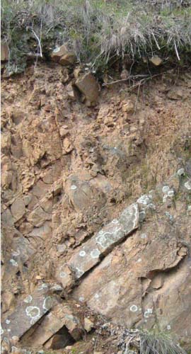 Shallow stony typical Talbotville soil profile: Cutting along Bairnsdale – Dargo Road |
Subsoil | |||
| B | 5 – 22 cm | Strong brown (7.5YR5/6); gravelly clay loam; apedal; friable, moist; 30% small bedrock fragments up to 20 mm; fragments up to 80 mm common below 10 cm; pH 5.0: | |
| R | 22+ cm | Bedrock. |
Key Profile Features:
- Soil will only support shrubby vegetation.
Chemical and Physical Analysis:
Horizon | Horizon Depth (cm) | pH (water) | EC dS/m | Organic Carbon % | Total Nitrogen % | Free Fe2O3 % w/w | Exchangeable Acididty meq/100g | Exchangeable Cations | Coarse Sand (0.2-2.0 mm) % | Fine Sand (0.02-0.2 mm) % | Silt (0.002-0.02 mm) % | Clay (<0.002 mm) % | |||
Ca | Mg | K | Na | ||||||||||||
meq/100g | |||||||||||||||
A1 | 0-5 | 4.8 | <0.05 | 3.8 | 0.19 | 2.6 | 30.5 | 0.05 | 0.09 | 0.7 | 0.07 | 18 | 18 | 31 | 19 |
B | 5-10 | 5.0 | <0.05 | 1.8 | 0.11 | 2.9 | 20.7 | <0.05 | 0.05 | 0.7 | 0.09 | 15 | 23 | 34 | 23 |
B | 10-20 | 5.0 | <0.05 | 1.8 | 0.10 | 3.3 | 21.2 | <0.05 | 0.08 | 0.7 | 0.05 | 13 | 22 | 35 | 28 |
Profile Described By: J.M. Aldrick, 1978.