Victorian Resources Online (archived)
GRES708
Location: Bairnsdale East
Australian Soil Classification: Melanic, Eutrophic, Red DERMOSOL
Map Unit: Tinamba
Previous Site Name: AL58
General Landscape Description: Gently undulating plain.
Site Description: 4% slope of a relict terrace
Land Use: Pasture
Native Vegetation: Dry valley forest
Geology: Pleistocene alluvial sediments
Soil Profile Morphology:
Surface Soil
| A11 | 0 – 15 cm | Black (10YR2/1); clay loam; strong angular blocky structure (10 mm); hard when dry; gradual change to: | 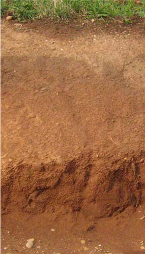 Soil exposure in channel near Hands Road, Lindenow. |
| A12 | 15 – 20 cm | Dark brown (7.5YR3/2); clay loam; weak angular blocky structure (5 mm); hard dry; clear change to: | |
| A2 | 20 – 40 cm | Dark brown (7.5YR3/4); clay loam; massive; very hard dry; clear change to: | |
| A3 | 40 – 70 cm | Dark brown (7.5YR3/4) with common faint reddish brown mottles; light clay; weak subangular blocky structure (20 mm); very hard dry; gradual change to: | |
| Subsoil | |||
| B2 | 70 – 105 cm | Yellowish red (5YR4/6); medium clay; abundant reddish brown mottles and common black mottles; moderate angular blocky structure (20 mm); very hard dry; gradual change to: | |
| C | 105 – 150+ cm | Reddish brown (5YR4/4) with common faint brown mottles; light clay; massive; hard dry. |
Key Profile Features:
- Soil sampled by Aldrick et al. (1992) is somewhat atypical as it has a black surface. Normally the Tinamba soils have a dark brown surface similar to that in the above photograph.
- Deep surface soil, but the subsurface sets hard when dry.
- Gradual increase in texture to 105 cm.
Soil Profile Characteristics:
Salinity rating | |||
Surface soil (A11 horizon) | Moderately Acid | Very Low | - |
Subsurface soil (A2 horizon) | Slightly Acid | Very Low | - |
Subsoil (B horizon) | Slightly Alkaline | Very Low | Sodic |
Chemical and Physical Analysis:
Horizon | Horizon Depth (cm) | pH (water) | EC dS/m | Organic Carbon % | Total Nitrogen % | Free Fe2O3 % w/w | Exchangeable Cations | Gravel % | Coarse Sand (0.2-2.0 mm) % | Fine Sand (0.02-0.2 mm) % | Silt (0.002-0.02 mm) % | Clay (<0.002 mm) % | |||
Ca | Mg | K | Na | ||||||||||||
meq/100g | |||||||||||||||
A11 | 0-10 | 5.7 | 0.09 | 3.5 | 0.35 | 5.3 | 1.8 | 0.8 | 0.3 | 7 | 5 | 47 | 22 | 22 | |
A2 | 20-30 | 6.1 | 0.05 | 1.6 | 0.14 | 1.4 | 4.7 | 1.4 | 0.2 | 0.2 | 4 | 2 | 53 | 22 | 20 |
A3 | 40-60 | 6.8 | 0.02 | 1.4 | 2.5 | 1.5 | 0.1 | 0.2 | 1 | 3 | 57 | 21 | 19 | ||
B2 | 70-90 | 7.2 | 0.08 | 2.8 | 2.6 | 4.5 | 0.2 | 1.1 | 3 | 3 | 45 | 15 | 33 | ||
C | 120-150 | 7.4 | 0.10 | 2.0 | 3.8 | 0.1 | 1.4 | 0 | 4 | 58 | 15 | 23 | |||
Management Considerations
Surface (A) horizons
- The surface soil is relatively deep, providing a good environment for plant growth provided the soil is moist.
- The surface soil has a high fine sand content (47%). When cultivated in a dry condition it will become ‘powdery’ and subsequent rainfall may result in surface sealing occurring. Soils such as these rely to a large extent on organic matter for maintaining aggregation. The level of organic carbon measured at the sample site is moderate, with an organic matter estimated at 6%.
- The potassium levels in the soil are high and no response to potassium fertiliser would be expected.
Subsoil (B) horizon
- Although water and root movement may be restricted by the sodic and clayey upper subsoil, the surface soil is sufficiently deep for adequate root growth.
Profile Described By: J.M. Aldrick, 1978.