Victorian Resources Online (archived)
Dookie
Geology of the Dookie Region | Dookie Soil Pits
| The Report: 'Soil, Land-Use, and Erosion Survey around Dookie, Victoria' was published by CSIRO in 1949. This general survey was carried out by R.G. Downes and covered an area of some 1554 square kilometres in order to provide basic information concerning soils, soil erosion, climate and land use which could be used to support soil conservation in that district. The report is available below, together with two of the associated maps. | 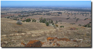 View from Mt Major looking south (Photo: David Rees, DPI). |
This detailed soil map was originally published in the above report: 'Soil, Land-Use and Erosion Survey around Dookie, Victoria' by R.G Downes (1949). It covers an area of 438 square kilometres and was prepared at a scale of 1:32 000. Some 27 Soil Reference Sites are associated with this map - details of which can be found in the original report. |
To view the information PDF requires the use of a PDF reader. This can be installed for free from the Adobe website (external link).
| 'Soil, Land-Use, and Erosion Survey around Dookie, Victoria' | |||
 | Summary (PDF 40KB) | Parts 1, 2 & 3 - Introduction, Climate & Vegetation Part A (PDF 1.4MB) | Part B (PDF 434KB) |
Parts 4 & 5 - Geology and Physiography, Soils Classification and Relationships (PDF 861KB) | Parts 6 & 7 - Soils Chemical and Physical Characteristics, Soil Erosion (PDF 1.2MB) | Parts 8, 9, 10 & 11 - Watersheds and Drainage Pattern, Agriculture and Land Use, Acknowledgements, References (PDF 1.3MB) | |
Topography, Hydrography and Soil Erosion Map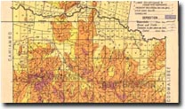 Dookie Topography, Hydrography and Soil Erosion | Soil Association Map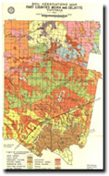 Soil Association, Part Counties Moira & Delatite | Land Class Map 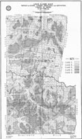 Dookie Land Class |