Victorian Resources Online (archived)
Site GN10
| Location: Dookie | |
| General Landscape Description: Upper slope of hillslope (2 degree slope) with a NNW aspect. | Australian Soil Classification: Haplic, Eutrophic, Red DERMOSOL |
| Soil Mapping Unit: Dookie loam (Downes, 1949). | Soil Management Unit (Briggs 1995): 'Heavy Red'. |
| Occurrence: Sloping ground downslope from hill country, especially around Mt. Major. This soil is found in areas generally higher up the slope than the 'Dookie Red' soils and is generally heavier in texture. | |
| Site Description: Paddock with wheat stubble. | |
| Native Vegetation: The native vegetation on these soils ranges from Yellow box (Eucalyptus melliodora) and White cypress pine/Murray pine (Callitris columellaris), to Sheoak (Casuarina stricta) and Grey box (Eucalyptus microcarpa). | |
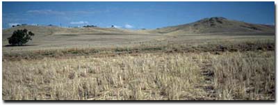 Site GN10 Landscape |
Soil Profile Morphology:
Surface Soil
| A1 | 0-15 cm | Dusky red (5YR3/4); heavy clay loam (fine sandy); hardsetting; moderate coarse to very coarse polyhedral structure; firm consistence (dry); pH 5.8; clear and smooth change to: | 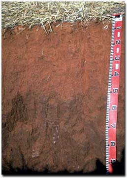 Site GN10 Profile |
| Subsoil | |||
| B21 | 15-35 cm | Dark red (2.5YR3/6); light clay; moderate coarse blocky structure; strong consistence (dry); pH 6.7; clear and smooth change to: | |
| B22 | 35-50 cm | Dark red (2.5YR3/6); medium heavy clay; strong coarse to very coarse prismatic, parting to coarse blocky structure; very firm consistence (moist); few manganese soft concretions (1-2 mm); pH 7.1: | |
| B23 | 50+ cm | Medium heavy clay; strong coarse to very coarse prismatic, parting to coarse blocky structure; roots to 100 cm (tending to follow prisms); pH 8.3. | |
Key Profile Features:
- Lack of strong texture contrast between surface (A) horizon and subsoil (B21) horizon
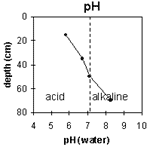
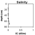
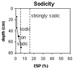
pH | Salinity Rating | |||
Surface soil (A1 horizon) | Moderately Acid | Very Low | Non-Sodic | None1 |
Upper subsoil 10 - 50 cm | Slightly Acid | Very Low | Non-Sodic | None |
Deeper subsoil (at 50 - 70 cm) | Moderately Alkaline | Very Low | Marginally Sodic | Slight2 |
 |  |  | 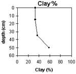 |
Horizon | Horizon Depth (cm) | pH (water) | pH (CaCl2) | EC 1:5 | Exchangeable Cations | Exch. Al mg/kg | Exch. Acidity meq/100g | Field Capacity pF 2.5 | Wilting Point pF 4.2 | Coarse Sand (0.2 -2 mm) | Fine Sand (0.02 -0.2 mm) | Silt (0.002 -0.02 mm) | Clay (<0.002 mm) | |||
Ca | Mg | K | Na | |||||||||||||
meq/100g | ||||||||||||||||
A1 | 0-15 | 5.8 | 4.8 | <0.05 | 7.2 | 3.3 | 0.6 | 0.1 | <10 | 11 | 29.1 | 16.7 | 3.6 | 34 | 25.5 | 33 |
B21 | 15-35 | 6.7 | 5.4 | <0.05 | 7.9 | 5.8 | 0.2 | 0.1 | <10 | 8.2 | 28.7 | 15.5 | 4.6 | 33.7 | 21.5 | 36.5 |
B22 | 35-50 | 7.1 | 5.9 | <0.05 | 9.2 | 9.1 | 0.4 | 0.5 | <10 | 10 | vro | vro | 6.2 | 33 | 21.5 | 58.5 |
B23 | 50+ | 8.3 | 7 | 0.05 | 8.6 | 10.4 | 0.4 | 1.1 | 3.9 | 21.2 | 11.5 | |||||
Management Considerations (Briggs 1995):
Favourable Characteristics
- Drainage - These 'heavy red' soils tend to drain well but can be prone to soaks.
- Workability/Trafficability - These soils are generally easy to cultivate. However, they can become sticky when wet making cultivation difficult.
- Acidity/Alkalinity - The topsoil is moderately acid but becomes neutral to alkaline with depth. These soils have a reasonable ability to resist further acidification.
- Erosion - The heavy reds have the potential of eroding when there is insufficient ground cover and when the ground is steep.
- Weeds - Wild radish was mentioned as a limiting feature of these heavy red soils.
- This soil is considered to be a good cropping soil. Direct drilling is a feasible option that will help maintain soil structure.
- Current Possibilities - Wheat, oats, barley, triticale, lupins, peas, faba beans, chick peas, linseed, lentils.
- Further Possibilities - Canola, linola.
Pasture Considerations
- The soil is also considered productive grazing country. Deeper rooted perennials may be able to tap into subsoil moisture and decrease groundwater recharge.
- Current Possibilities - Phalaris (Australian Holdfast, Sirosa mix), Trikkala, Goulburn, Seaton Park, Lucerne.
Management Considerations based on booklet: ' Soil Management Units in the Dookie Land Management Group Area' - compiled by Suzanne Briggs. Agriculture Victoria,1995.
Downes R.G. (1949). 'Soil, Land-Use, and Erosion Survey around Dookie, Victoria' , Bulletin 243, CSIRO, Victoria.
Profile Described By: Mark Imhof, John Martin and Sonia Thompson (4/5/94).