Victorian Resources Online (archived)
Site GN13
| Location: Dookie. | |
| Australian Soil Classification: Endohypersodic, Epipedal, Grey VERTOSOL. | Great Soil Group: grey clay. |
| General Landscape Description: Level plain. | Soil Mapping Unit: Congupna clay (Downes, 1949). |
| Soil Management Unit (Briggs 1995): 'Grey Clay - Dookie'. | |
| Occurrence: Generally found on the outskirts of the Land Management Group area on the flat low-lying country, particularly along water courses and depressions. | |
| Site Description: Pasture. | |
| Native Vegetation: The dominant tree species are Grey box (Eucalyptus microcarpa) and Buloke (Casuarina luehmannii). Yellow box (Eucalyptus melliodora) and Sheoak (Casuarina stricta) can be found on the lighter and better-drained soils. River red gum (Eucalyptus camaldulensis) is associated with the water courses. | |
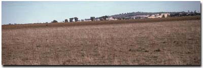 Site GN13 Landscape |
Soil Profile Morphology:
Surface Soil
| A1 | 0-10 cm | Brown (10YR4/3); light clay; weak medium blocky structure; strong consistence (dry); rusty root channel mottling (10%); pH 5.5; sharp change to: | 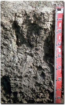 Site GN13 Profile |
| A2 | 10-25 cm | Greyish brown (10YR5/2); conspicuously bleached (10YR8/1 dry); silty clay; few (5%) hard ferruginous nodules (< 10 mm in size). Note: There is a discontinuous A2 horizon that may or may not be present. It is probably associated with the depression component of gilgai microrelief. | |
| Subsoil | |||
| B21 | 10-25 cm | Dark grey (10YR4/1) with diffuse yellowish brown (10YR5/6) mottles; heavy clay; strong coarse blocky, parting to strong medium to coarse prismatic structure; strong consistence (moist); very few (2%) soft (manganiferous?) segregations ( 5 mm in size); pH 7.2; clear change to: | |
| B22 | 25-70 cm | Dark grey (10YR /1); heavy clay; strong coarse lenticular, parting to moderate fine lenticular structure; strong consistence (moist); pH 8.2; clear change to: | |
| B23 | 70+ cm | Dark brown (10YR 4/3); heavy clay; firm consistence (moist); very few gypsum crystals (nests of 1-2 mm in size); slight effervescence; pH 8.3. | |
Key Profile Features:
- Clay texture throughout soil profile.
- Vertic properties (i.e. lenticular structure).
- Large surface cracks when dry.
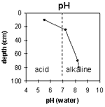
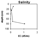
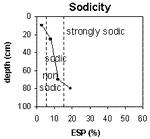
pH | Salinity Rating | |||
Surface soil (A1 horizon) | Strongly Acid | Low | Non-Sodic | None |
Upper subsoil (10 - 25 cm) | Slightly Alkaline | Very Low | Sodic | None1 |
Deeper subsoil (at 70+ cm) | Moderately Alkaline | High | Strongly Sodic | None2 |
 |  |  | 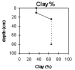 |
Horizon | Horizon Depth (cm) | pH (water) | pH (CaCl2) | EC 1:5 | Exchangeable Cations | Exch. Al mg/kg | Exch. Acidity meq/100g | Field Capacity pF 2.5 | Wilting Point pF 4.2 | Coarse Sand (0.2 -2 mm) | Fine Sand (0.02 -0.2 mm) | Silt (0.002 -0.02 mm) | Clay (<0.002 mm) | |||
Ca | Mg | K | Na | |||||||||||||
meq/100g | ||||||||||||||||
A1 | 0-10 | 5.5 | 4.8 | 0.20 | 6.5 | 6.3 | 0.7 | 0.4 | <10 | 13 | 35.4 | 15.7 | 6.4 | 26.1 | 24.0 | 35.0 |
B21 | 10-25 | 7.2 | 5.9 | 0.06 | 12.1 | 16.2 | 1.1 | 2.3 | <10 | 8.5 | 43.1 | 21.5 | 1.3 | 13.0 | 14.0 | 65.0 |
B22 | 25-70 | 8.2 | 7.0 | 0.16 | 12.1 | 18.3 | 0.8 | 4.1 | ||||||||
B23 | 70+ | 8.3 | 7.8 | 1.04 | 10.1 | 17.0 | 0.8 | 6.3 | ||||||||
Management Considerations (Briggs 1995):
Favourable Characteristics
- Acidity/Alkalinity - The grey clay has a moderately to strongly acidic topsoil and becomes more alkaline further down the profile.
- Fertility - This soil is generally fertile with high levels of sulphur. Organic matter levels are generally low. There is some phosphorus fixation, meaning that not all applied phosphorus will be freely available to plants.
- Moisture Availability - These soils have a high clay content and therefore a greater water holding capacity. The extra water held by this soil allows for an extended season for plant growth. However, many plants will be unable to extract water when soil moisture levels become low.
Limiting Features
- Drainage - The drainage on these soils is generally poor. This combined with run-off from higher areas causes the grey clays to become waterlogged.
- Soil Structure - This soil has a tendency to run together and set hard. Where gypsum has been applied, there has been a visible response only after repeated applications and deep ripping.
- Workability/Trafficability - The grey clays are difficult to cultivate and can come up 'lumpy' when worked. The soil becomes sticky when wet which can limit the trafficability and workability of machinery.
- This soil is not regarded as a cropping soil. It is difficult to cultivate and becomes easily waterlogged. Very few crops are successful on this soil type. Direct drilling has been used on the grey clays with visible soil structure improvement. Crop varieties need to be chosen to suit the wet conditions.
- Current Possibilities - Oats, triticale.
- Further Possibilities - Linola.
Pasture Considerations
- Pasture that can withstand waterlogging and heavy soils may be suitable. Deep-rooted perennials may be able to tap into subsoil moisture as well as reduce topsoil moisture. This may increase productivity.
- Current Possibilities - Phalaris (Australian, Holdfast, Sirosa mix), Trikkala, Balansa clover, later maturing clover in your pasture mix (e.g. Larisa depending on how long the soil "hangs on").
- Further Possibilities - Agroforestry.
References:
Management Considerations based on booklet: ' Soil Management Units in the Dookie Land Management Group Area' - compiled by Suzanne Briggs. Agriculture Victoria,1995.
Downes R.G. (1949). 'Soil, Land-Use, and Erosion Survey around Dookie, Victoria' , Bulletin 243, CSIRO, Victoria.
Profile Described By: Mark Imhof, John Martin and Sonia Thompson (4/5/94).