Victorian Resources Online (archived)
Site GN7
| Location: Dookie | Australian Soil Classification: Haplic, Eutrophic, Red FERROSOL |
| Geology: Cambrian. | General Landscape Description: Long lower hillslope. |
| Soil Mapping Unit: Dookie clay loam (Downes 1949). Common Name: 'Dookie Red'. | |
| Occurrence: The 'Dookie Red' soil can be found east and west of the Dookie township on a variety of locations, including flat, undulating to rising hilly country. | |
| Site Description: Mixed cropping paddock (lupins, cereals). | |
| Native Vegetation: Yellow box (Eucalyptus melliodora), White cypress pine/Murray pine (Callitris columellaris) and Sheoak (Casuarina stricta) are commonly associated with these soils. The occasional Grey box (Eucalyptus microcarpa) and Buloke (Casuarina luehmannii) may be present. | |
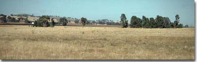 Site GN7 Landscape |
Soil Profile Morphology:
Surface Soil
| A1 | 0-15 cm | Dusky red (5YR3/4), fine sandy clay loam; hardsetting; weakly structured; very firm to strong consistence (dry); very few (2%) quartz fragments (1-5 mm size); pH 5.6; clear and smooth change to: | 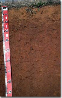 Site GN7 - Red Dermosol Profile |
| Subsoil | |||
| B21 | 15-30 cm | Red (2.5YR4/6), light clay; strong coarse to medium blocky structure; very firm consistence (dry); very few (2-5 %) ferruginous nodules (4-5 mm size); pH 6.0; gradual change to: | |
| B22 | 30-80 cm | Red (2.5YR4/6), medium heavy clay; strong very fine blocky structure; shiny ped faces; very firm consistence (wet); very few (2-5%) ferruginous nodules (4-5 mm); gradual change to: | |
| B23 | 80+ cm | Red (2.5YR4/6), heavy clay; strong fine blocky structure; shiny ped faces; weak consistence (weak). | |
Key Profile Features:
- Lack of strong texture contrast between surface (A) horizon and subsoil (B21) horizon.
Identifying Characteristic
- Regarded as the most productive soil in the area. It is a well drained light textured soil with a deep red soil profile.
Soil Profile Characteristics:
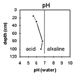
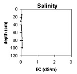
pH | Salinity | |||
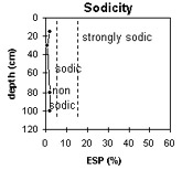
Surface soil (A1 horizon) | Moderately Acid | Very low | Non-Sodic | None1 |
Upper subsoil 15 - 30 cm | Moderately Acid | Very Low | Non-Sodic | None2 |
Deeper subsoil (at 80+ cm) | Slightly Acid | Very Low | Non-Sodic | None |
 |  |  |  |
Horizon | Horizon Depth (cm) | pH (water) | pH (CaCl2) | EC 1:5 | Exchangeable Cations | Exch. Al mg/kg | Exch. Acidity meq/100 g | Field Capacity pF 2.5 | Wilting Point pF 4.2 | Coarse Sand (0.2 -2 mm) | Fine Sand (0.02 -0.2 mm) | Silt (0.002 -0.02 mm) | Clay (<0.002 mm) | |||
Ca | Mg | K | Na | |||||||||||||
meq/100g | ||||||||||||||||
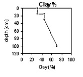
A1 | 0-15 | 5.6 | 4.5 | 0.05 | 4.7 | 1.8 | 1.2 | 0.1 | <10 | 11 | 25.9 | 13.6 | 7.1 | 40.4 | 17.0 | 30.5 |
B21 | 15-30 | 6.0 | 5.0 | <0.05 | 5.6 | 3.2 | 1.2 | 0.1 | <10 | 8.4 | 24.8 | 15.7 | 5.6 | 31.6 | 13.5 | 45.0 |
B22 | 30-80 | 6.7 | 5.9 | 0.07 | 6.6 | 8.3 | 1.2 | 0.2 | <10 | 8.6 | 3.4 | 15.3 | 6.0 | 70.0 | ||
B23 | 80+ | 6.5 | 5.7 | 0.07 | 6.1 | 11.3 | 0.6 | 0.3 | ||||||||
Management Considerations (Briggs 1995):
Favourable Characteristics
- Acidity/Alkalinity - The 'Dookie Red' topsoil is slightly acidic and becomes less acidic down the profile. This is within the ideal growing range for crop and pasture production.
- Drainage - The 'Dookie Red' is a free-draining porous soil.
- Soil Structure - The 'Dookie Red' generally has a stable soil structure but if overcultivated it does have the potential to run together and set hard. The surface soil disperses slightly (and the upper subsoil strongly) after remoulding. This indicates that some structural degradation may occur if the soil is cultivated whilst in a condition that is too moist .
- Workability/Trafficability - The light soil texture makes the soil friable and easy to cultivate. The 'Dookie Red' soil is well suited to direct drilling.
Limiting Features
- Drainage - This soil can suffer from soaks which affects drainage considerably.
- Weeds - Wild radish and tomato weed were mentioned as a limiting feature of areas with 'Dookie Red' soil.
- Workability/Trafficability - This soil has the tendency to become sticky when wet which can make cultivation difficult. Cultivation or trafficking when the soil is in a moist to wet condition may result in some compaction occurring.
- The staining nature of the Dookie Red soil may be a limiting feature especially when keeping sheep clean for shearing.
Cropping Considerations
- This soil is considered to be the most productive soil in the district. Direct drilling is a feasible option which will help maintain the soil structure. Generally any crop can be grown in this soil.
- Current Possibilities - Wheat, barley, oats, triticale, lupins (broad and narrow leaf varieties), canola, linola, linseed, lentils.
Pasture Considerations
- As well as being good cropping country this soil is also classed as productive grazing country. Deeper-rooted perennials may be able to tap into subsoil moisture and decrease groundwater recharge on the hilly sites.
- Current Possibilities - Lucerne, phalaris (Australian, Holdfast, Sirosa mix), cocksfoot (Porto), Trikkala, Goulburn, Seaton Park.
References:
Management Considerations based on booklet: ' Soil Management Units in the Dookie Land Management Group Area' - compiled by Suzanne Briggs. Agriculture Victoria,1995.
Downes R.G. (1949). 'Soil, Land-Use, and Erosion Survey around Dookie, Victoria' , Bulletin 243, CSIRO, Victoria.
Profile Described By: Mark Imhof, John Martin and Sonia Thompson (4/5/94).