Victorian Resources Online (archived)
Site GN8
| Location: Dookie | |
| Australian Soil Classification: Epicalcareous - Endohypersodic, Self-mulching, Grey VERTOSOL | |
| Great Soil Group: grey clay. | Geology: Alluvial deposits. |
| General Landscape Description: Level Plain. | Soil Management Unit (Briggs 1995): Black Self-Mulching. |
| Occurrence: Large areas are generally found on the north side of Mt. Major on flat to sloping country. Smaller areas are scattered around the region in low lying areas and depressions. | |
| Site Description: Lucerne paddock. | |
| Native Vegetation: This soil is found mainly on open plain country with few or no trees. The occasional Grey box (Eucalyptus microcarpa) and Buloke (Casuarina luehmannii) can be found on the verge of the soil boundary. | |
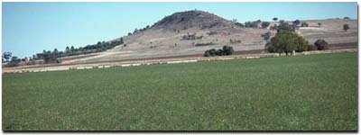 Site GN8 Landscape. |
Soil Profile Morphology:
Surface Soil
| A1 | 0-5 cm | Dark greyish brown (10YR4/2); medium clay; self mulching; firm consistence (dry); pH 7.7; sharp change to: | 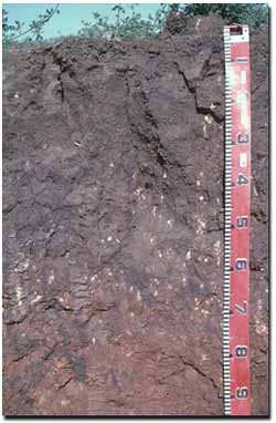 Site GN8 Profile |
| Subsoil | |||
| B21 | 5-10 cm | Dark greyish brown (10YR4/2); heavy clay; very coarse blocky structure, tending to some platey structure; rigid consistence (dry); very few (< 2%) calcium carbonate hard nodules; gradual change to: | |
| B21k | 10-50 cm | Dark greyish brown (10YR4/2); heavy clay; very coarse prismatic, parting to very coarse blocky structure; very few (< 2%) calcium carbonate nodules; pH 7.8; gradual change to: | |
| B22 | 50-70 cm | Dark greyish brown (10YR4/2) with strong brown (7.5YR 5/6) mottles; heavy clay; few (2-5 %) soft and hard carbonate nodules; pH 8.9; gradual change to: | |
| B23 | 70+ cm | Dark greyish brown (10YR4/2) with strong brown (7.5YR 5/6) mottles; calcium carbonate nodules increase with depth. | |
Key Profile Feature:
Identifying Characteristic
- The black self-mulching soil is well recognised for its shrink/swell characteristic, swelling when wet and shrinking when dry. As the soil shrinks it tends to crack wide open and crumble into friable aggregates (called self-mulching) at the surface. This soil is noted for being sticky when wet.
Soil Profile Characteristics:
pH | Salinity Rating | |||
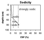
Surface soil (A1 horizon) | Slightly Alkaline | Very low | Non-Sodic | None |
Upper subsoil (5 -10 cm) | Slightly Alkaline | Very Low | Non-Sodic | None |
Deeper subsoil (at 70+ cm) | Very Strongly Alkaline | Low-Medium | Sodic | Moderate1 |
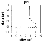 | 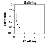 |  | 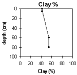 |
Horizon | Horizon Depth (cm) | pH (water) | pH (CaCl2) | EC 1:5 | Exchangeable Cations | Exch. Al mg/kg | Exch. Acidity meq/ 100g | Field Capacity pF 2.5 | Wilting Point pF 4.2 | Coarse Sand (0.2 -2 mm) | Fine Sand (0.02 -0.2 mm) | Silt (0.002 -0.02 mm) | Clay (<0.002 mm) | |||
Ca | Mg | K | Na | |||||||||||||
meq/100g | ||||||||||||||||
A1 | 0-5 | 7.7 | 7.1 | 0.16 | 26.6 | 8.7 | 3.5 | 0.2 | 15 | 5.0 | 42.6 | 33 | 2.6 | 21.0 | 26.5 | 41.5 |
B21 | 5-10 | 7.8 | 7.2 | 0.19 | 29.2 | 9.0 | 1.5 | 0.9 | 14 | 4.6 | 41.3 | 30.3 | 2.2 | 21.5 | 14.5 | 54.0 |
B22 | 50-70 | 8.9 | 8.0 | 0.32 | 18.4 | 16.2 | 0.9 | 4.9 | <10 | 3.3 | 2.2 | 21.3 | 14.5 | 54.5 | ||
B23 | 70+ | 8.9 | 8.1 | 0.53 | 14.4 | 17.1 | 0.9 | 6.1 | ||||||||
Management Considerations (Briggs 1995):
Favourable Characteristics
- Acidity/Alkalinity - The black self-mulching soils are generally more alkaline in the topsoil and subsoil than other soils and are well buffered against pH changes.
- Drainage - The black self-mulching soils are free draining and can hold more water than most soils before becoming waterlogged.
- Fertility - Generally regarded as fertile soils. These soils generally have low levels of organic matter and high levels of sulphur. There is some phosphorus fixation, meaning not all applied phosphorus will be freely available to plants.
- Moisture Availability - The high level of clay in the black self-mulching soils enable the soil to hold onto large amounts of water. Hence the growing season of crops and pastures on the black self-mulching soil is effectively extended. However, the high wilting point values indicate that plants will be unable to effectively utilise water when the soil dries out, compared to other lighter textured soil types as these soils hold on to water tightly at low moisture contents.
- Drainage - This soil can suffer from soaks that can make them quite wet and boggy and make management difficult.
- Erosion - This soil has the potential to erode after heavy rains particularly if there is little or no ground cover.
- Weeds - Variegated thistles were mentioned by landholders as a limiting feature of areas with black self-mulching soil.
- Workability/Trafficability - When wet the black self-mulching soil becomes sticky and heavy reducing the workability. Clay soils such as these are also liable to compaction if trafficked or over-cultivated when in a too moist condition (i.e. wetter than the plastic limit).
- This soil is regarded as good productive soil under favourable conditions. Direct drilling is a feasible option that can allow sowing before trafficability is restricted.
- Current Possibilities - Wheat, oats, triticale, barley, peas, chick peas, faba beans (do better if not waterlogged), safflower as a summer crop.
- Further Possibilities - Linola.
- This soil can limit winter grazing as it becomes sticky and puggy when wet. The establishment of lucerne for grazing and hay production has proven successful and has also reduced rising water tables.
- Current Possibilities - Lucerne, phalaris (Australian, Holdfast, Sirosa mix). Later maturing clovers in pasture mix (e.g. Clare or Nuba) suitable for alkaline soils.
References:
Management Considerations based on booklet: ' Soil Management Units in the Dookie Land Management Group Area' - compiled by Suzanne Briggs. Agriculture Victoria,1995.
Downes R.G. (1949). 'Soil, Land-Use, and Erosion Survey around Dookie, Victoria' , Bulletin 243, CSIRO, Victoria.
Profile Described By: Mark Imhof, John Martin and Sonia Thompson (4/5/94).