Victorian Resources Online (archived)
Site GN9
| Location: Dookie | |
| Australian Soil Classification: Haplic, Eutrophic, Red CHROMOSOL (thin gravelly surface; moderately deep profile). | |
| General Landscape Description: Mid slope of hill (2-3 degrees slope) with a NW aspect. | Soil Mapping Unit: Skeletal Soils (Downes 1949). |
| Soil Management Unit (Briggs 1995): 'Rocky Grazing Country'. | Occurrence: Found on higher slopes and hill tops where topography and rocks limit cropping practices. |
| Site Description: Grazing paddock. | |
| Native Vegetation: Yellow box (Eucalyptus melliodora) are predominantly found in this soil. Found downslope are White cypress pine/Murray pine (Callitris columellaris) and Sheoak (Allocasuarina stricta), while Grey box (Eucalyptus microcarpa) can be found on the heavier sites. | |
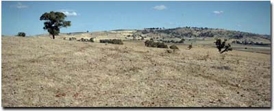 Site GN9 Landscape |
Soil Profile Morphology:
Surface Soil
| A1 | 0-10 cm | Dark red (2.5YR3/6); heavy clay loam (fine sandy); hardsetting; moderate coarse polyhedral structure; very firm consistence (dry); few surface rocks (sandstone and quartz); pH 6.3; sharp change to: | 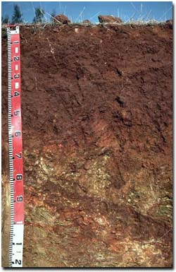 Site GN9 Profile |
| Subsoil | |||
| B21 | 10-50 cm | Dark red (2.5YR3/6); medium heavy clay; strong coarse to medium prismatic, parting to coarse blocky to fine blocky structure; strong consistence (dry); few (3%) coarse fragments of weathered parent rock (4 cm av. size); pH 6.8; sharp and wavy change to: | |
| B22 | 50-70 cm | Red (2.5YR4/6); medium clay; firm consistence (moist); pH 7.6; many (20-25 %) coarse fragments of weathered parent rock (1 cm av. size); sharp and irregular change to: | |
| C | 70+ cm | Weathered rock with some clay veins. | |
Key Profile Features:
- Strong texture contrast between surface (A1) and subsoil (B21) horizon
- Identifying Characteristics - These soils generally have a rocky surface and are found on the hill tops and higher ground. Often too rocky to crop, they are suitable for grazing over wet winter months as they stay dry.
Soil Profile Characteristics:
pH | Salinity Rating | |||
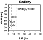
Surface soil (A1 horizon) | Slightly Acid | Low | Non-Sodic | None |
Upper subsoil 10 - 50 cm | Slightly Acid | Very Low | Non-Sodic | None |
Deeper subsoil (at 50 - 70 cm) | Slightly Alkaline | Very Low | Non-Sodic | None |
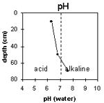 | 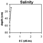 |  |  |
Horizon | Horizon Depth (cm) | pH (water) | pH (CaCl2) | EC 1:5 | Exchangeable Cations | Exch. Al mg/kg | Exch. Acidity meq/100 g | Field Capacity pF 2.5 | Wilting Point pF 4.2 | Coarse Sand (0.2 -2 mm) | Fine Sand (0.02 -0.2 mm) | Silt (0.002 -0.02 mm) | Clay (<0.00 2 mm) | |||
Ca | Mg | K | Na | |||||||||||||
meq/100g | ||||||||||||||||
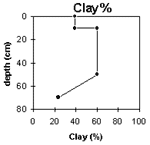
A1 | 0-10 | 6.3 | 5.7 | 0.14 | 8.5 | 6.6 | 1.4 | <0.1 | <10 | 2.7 | 28.3 | 17.3 | 13.4 | 27.9 | 13.5 | 39.0 |
B21 | 10-50 | 6.8 | 5.8 | <0.05 | 9.3 | 11.9 | 0.5 | 0.1 | <10 | 9.0 | 30.8 | 23.7 | 8.6 | 15.0 | 10.5 | 60.0 |
B22 | 50-70 | 7.9 | 6.6 | <0.05 | 20.5 | 27.6 | 0.2 | 0.2 | 11 | 7.5 | 14.7 | 30.7 | 26.0 | 23.0 | ||
C | 70+ | |||||||||||||||
Management Considerations (Briggs 1995):
Favourable Characteristics
- Drainage - The sloping topography and free-draining nature of the soil results in good drainage.
- Erosion - This soil has the potential to erode when there is insufficient ground cover and when the slope is quite steep.
- Recharge Hazard - These soils are considered to be high recharge soils and high contributors to the groundwater levels lower in the landscape.
- Workability/Trafficability - Cropping the rocky grazing country has proven difficult due to topography and rocky surfaces.
- This soil is not suited to cropping due to the topography and surface rock cover.
Pasture Considerations
- The rocky grazing country provides good winter grazing, as generally the soils are drier than for the heavier soils. Pasture establishment is feasible by aerial sowing. This will provide ground cover and increase productivity of the area.
- Current Possibilities - Phalaris (Australian Holdfast, Sirosa mix), cocksfoot (Porto), Trikkala, Goulburn, lucerne (depending on pH and terrain).
References:
Management Considerations based on booklet: ' Soil Management Units in the Dookie Land Management Group Area' - compiled by Suzanne Briggs. Agriculture Victoria,1995.
Downes R.G. (1949). 'Soil, Land-Use, and Erosion Survey around Dookie, Victoria' , Bulletin 243, CSIRO, Victoria.
Profile Described By: Mark Imhof, John Martin and Sonia Thompson (4/5/94).