Victorian Resources Online (archived)
CRC8
Location: Warrayure
Australian Soil Classification: Ferric (& Magnesic) Subnatric, Brown SODOSOL (very thick sandy surface horizons)
Geology: Possible strand line (Dorodong sands).
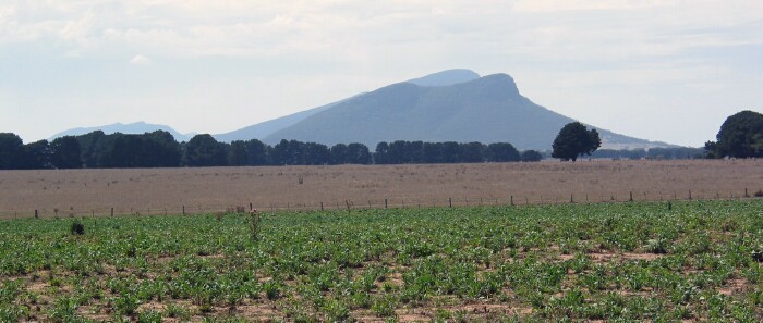
Site CRC8 Landscape
Soil Profile Morphology:
Surface Soil
| A1 | 0-20 cm | Dark brown (10YR3/3); loamy sand; soft surface condition; very weak consistence (dry); pH 5.6: | 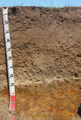 Site CRC8 profile |
| A21 | 20-40 cm | Brown (10YR4/3); sand; very weak consistence (dry); pH 5.6: | |
| A22c | 40-70 cm | Dark yellowish brown (10YR4/4); sand; many (40%) ferruginous nodules (rounded pisoliths) (4-12 mm); pH 6.4: | |
| A23c | 70-90 cm | Yellowish brown (10YR5/4); conspicuously bleached; sand; very many (50%) round and sub-angular ferruginous nodules or pisoliths (4-20 mm in size); abrupt change to; pH 6.7: | |
| Subsoil | |||
| B1 | 90-105 cm | Dark yellowish brown (10YR4/4) with yellowish brown (10YR5/6) and red (2.5YR5/8) mottles; heavy sandy clay loam; weakly structured; very firm consistence (moist); few (5%) ferruginous nodules; pH 7.2: | |
| B21 | 105-120+ cm | Dark yellowish brown (10YR4/4) with reddish yellow (7.5YR6/8) and dark red (2.5YR4/8) mottles; light medium clay; strong-moderate coarse to medium polyhedral structure (in patches); firm to very firm consistence (moist); pH 5.1. | |
Key Profile Features:
- Strong texture contrast between sandy surface (A) horizons and subsoil (B21) horizon.
- Very thick sandy surface horizons.
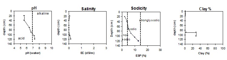
Soil Profile Characteristics:
pH | Salinity Rating | |||
Surface (A1 horizon) | Moderately Acid | Very Low | Non-Sodic | None |
Subsoil (B1 horizon) | Slightly Alkaline | Very Low | Sodic | None |
Deeper subsoil (at 105-120 cm) | Slightly Alkaline | Low | Sodic | Moderate |
 |
Chemical and Physical Analysis:
Horizon | Horizon Depth (cm) | pH (water) | pH (CaCl2) | EC dS/m | Exchangeable Aluminium ppm | Exchangeable Acididty meq/100g | Exchangeable Cations | Coarse Sand (0.2-2.0 mm) % | Fine Sand (0.02-0.2 mm) % | Silt (0.002-0.02 mm) % | Clay (<0.002 mm) % | |||
Ca | Mg | K | Na | |||||||||||
meq/100g | ||||||||||||||
A1 | 0-20 | 5.6 | 4.8 | 0.06 | <10 | 4.5 | 1.7 | 082 | 0.13 | 0.13 | 68 | 20 | 8 | 1 |
A21 | 20-40 | 5.6 | 4.7 | <0.05 | <10 | 1.9 | 0.45 | 0.39 | <0.05 | 0.12 | ||||
A22c | 40-70 | 6.4 | 5.5 | <0.05 | <10 | 1.9 | 0.40 | 0.58 | <0.05 | 0.16 | ||||
A23c | 70-90 | 6.7 | 6.1 | <0.05 | 1.8 | 0.34 | 0.54 | <0.05 | 0.19 | 70 | 24 | 3 | 2 | |
B1 | 90-105 | 7.2 | 5.9 | 0.09 | 4.0 | 0.55 | 4.2 | 0.05 | 1.0 | 53 | 16 | 3 | 30 | |
B21 | 105-120 | 7.3 | 6.2 | 0.14 | 5.1 | 0.40 | 6.2 | 0.09 | 1.7 | |||||
Management Considerations:
Surface (A) Horizons
- The surface horizons are deep and sandy. Infiltration of water will be relatively rapid as a result and the surface soil will be well drained.
- The low wilting point in the surface horizons indicates that plants will be able to utilise very light rains when the soil is dry. However, due to the low water storage capacity, plants will soon suffer moisture stress unless further rain or watering occurs.
- The subsoil has very high levels of exchangeable magnesium relative to exchangeable calcium. This may result in nutrient imbalances e.g. calcium deficiency.
- The coarsely structured subsoil is sodic and disperses. This will result in restricted root and water movement in the subsoil. Water will tend to build up on the top of the subsoil in wet periods.