Victorian Resources Online (archived)
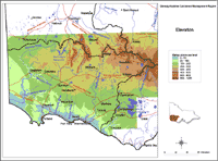
Elevation
The southern and western parts of the Glenelg-Hopkins Catchment Management Region are generally flat to gently undulating, up to 200 m above sea level (asl). The northern half of the region for the most part rises to 200-400 m asl, rising again in the Southern Grampians to a peak of 1,187 m at Mt William.
Other elevated parts of the region include: the Sierra Range, including Mt Abrupt at 826 m asl; the Dundas Tablelands where Mt Dundas peaks at 467 m asl and Mt Napier peaks at 439 m asl; the Victoria Range; the Black Range and the Merino Tablelands.
|
This elevation map provides a broadscale overview of the relief across the region. The Digital Elevation Model (DEM) was derived from 1:25 000 topographic data, including contours, spot heights, hydrology (stream enforced) and shore boundaries using ANUDEM software. The interpolation of topographic data is to a 20 m x 20 m grid, which has been resampled to 100 m cell size for display on this website. |
 Elevation Glenelg Region
|
|
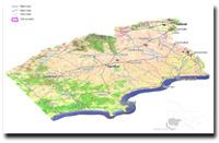 Glenelg Hopkins Catchment 3D Elevation