Victorian Resources Online (archived)
Local Government
The following Local Government Authorities have offices in the Glenelg-Hopkins Catchment Management Region:
|  Glenelg Shire Council Office |
These Local Government Authorities do not have offices in the Glenelg-Hopkins Catchment Management Region, but their boundaries do intersect the region:
- Shire of Corangamite (external link)
- City of Ballarat (external link)
- Shire of West Wimmera (external link
| The Local Government Areas (LGAs) map is intended to show the relative areas and boundaries of each council located within the region. Its intended use is for users to identify which local government area is relevant to their needs. Data for this map is derived from the Local Government Area layer (LGA100) of the (former) DPI/(former) DSE's Corporate Geospatial Data Library. This layer describes the post amalgamation LGA boundaries as defined by the Department of Finance. Place names (i.e. towns) are provided by Vicroads and AUSLIG. | 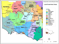 Glenelg-Hopkins Local Government Areas |