Victorian Resources Online (archived)
PVI10
Location: PVI Hamilton
Australian Soil Classification: Humose (& Vertic), Chromosolic, Redoxic, HYDROSOL
Northcote Factual Key: Dd 4.1
Great Soil Group: Humic gley
Geology: Alluvium overlying Quaternary basalt.
General Landscape Description: Level plain.
Soil Mapping Unit: Tabor loam.
Site Description: Grazing paddock.
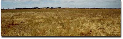 PVI10 Landscape |
Soil Profile Morphology:
Surface Soil
| A11 | 0-15 cm | Black (10YR2/1); loam; weak consistence (dry); pH 5.7; abrupt change to: | 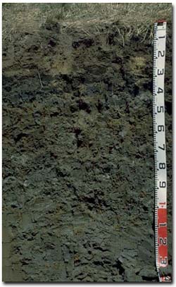 PVI10 Profile |
| A12 | 15-25 cm | Black (10YR2/1); clay loam (organic); weak consistence (dry); some laminated peat in patches; pH 5.8; clear change to: | |
| Subsoil | |||
| B21 | 25-45 cm | Very dark grey (2.5Y3/0); medium heavy clay; moderate very coarse prismatic, parting to strong coarse blocky structure; strong consistence (dry); pH 6.5; clear change to: | |
| B22 | 45-100 cm | Grey (10YR5/1) with many (20%) strong brown (7.5YR5/6) mottles; medium clay; moderate coarse prismatic, parting to strong medium to very fine lenticular structure; slickensides present; very firm consistence (moist); pH 7.8; gradual change to: | |
| B23 | 100-150 cm | Grey (10YR5/1) with few (10%) strong brown (7.5YR5/6) mottles; light medium clay; strong very fine lenticular structure; very firm consistence (moist); very few (<1%) ferruginous nodules (5-10 mm); pH 8.1; clear change to: | |
| B3 | 150+ cm | Greyish brown (2.5Y5/2); light medium clay; weak consistence (moist); pH 8.2. | |
Key Profile Features:
- High organic matter content in the surface (A) horizons.
- Strong texture contrast between surface (A) horizons and subsoil (B21) horizon.
- Vertic properties in the deeper subsoil i.e. lenticular structure and slickensides.
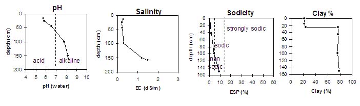
Soil Profile Characteristics:
pH | Salinity Rating | |||
Surface Soil (A1 horizon) | Moderately Acid | Low-Medium | - | None |
Upper Subsoil (25- 45 cm) | Slightly Acid | Low | Non-Sodic | None |
Deeper Subsoil (100-150 cm) | Moderately Alkaline | High | Sodic | - |
 |
Horizon | Horizon Depth (cm) | pH (water) | pH (CaCl2) | EC 1:5 | NaCI % | Exchangeable Cations | |||
Ca | Mg | K | Na | ||||||
meq/100g | |||||||||
A1 | 0-15 | 5.7 | 5.3 | 0.29 | 7.4 | 5.7 | 2 | 0.6 | |
A12 | 15-25 | 5.8 | 5.2 | 0.22 | 23 | 15 | 1.8 | 0.95 | |
B21 | 25-45 | 6.5 | 5.8 | 0.24 | 20 | 19 | 1.6 | 0.94 | |
B22 | 45-100 | 7.8 | 7.2 | 0.31 | <0.01 | 15 | 19 | 1.7 | 1.3 |
B23 | 100-150 | 8.1 | 7.9 | 1.2 | 0.05 | 12 | 22 | 1.8 | 3.6 |
B3 | 150+ | 8.2 | 8.0 | 1.5 | |||||
Horizon | Horizon Depth (cm) | Exchangeable Aluminium mg/kg | Exchangeable Acidity meq/100g | Field Capacity pF2.5 | Wilting Point pF4.2 | Coarse Sand (0.2- 2.0 mm) | Fine Sand (0.02- 0.2 mm) | Silt (0.002- 0.02 mm) | Clay (<0.002 mm) |
A1 | 0-15 | 16 | 27 | 68 | 36 | 22 | 12 | 20 | 22 |
A12 | 15-25 | 17 | 26 | 56 | 40 | 34 | 8 | 12 | 24 |
B21 | 25-45 | 15 | 67 | 41 | 1 | 3 | 11 | 78 | |
B22 | 45-100 | 64 | 37 | 1 | 7 | 11 | 76 | ||
B23 | 100-150 | 66 | 37 | 1 | 5 | 10 | 79 | ||
B3 | 150+ |
Profile Described By: Mark Imhof, Paul Rampant (January 2001).