Victorian Resources Online (archived)
PVI11
Location: PVI Hamilton
Australian Soil Classification: Mottled, Epipedal, Black VERTOSOL (very gravelly surface)
Northcote Factual Key: Ug 5.16
Great Soil Group: Possibly Wiesenboden
Geology: Alluvium overlying Quaternary basalt.
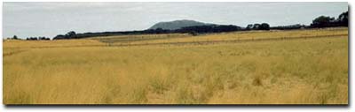
General Landscape Description: Level plain (former swamp).
Soil Mapping Unit: Buckley Clay.
Site Description: Grazing paddock.
 PVI11 Landscape |
Soil Profile Morphology:
Surface Soil
| A11 | 0-10 cm | Very dark greyish brown (10YR3/2); gravelly clay; weak consistence (dry); many (40%) ferruginous nodules (2-5 mm); rusty root channel mottling; pH 5.7; clear change to: | 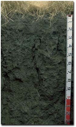 PVI11 Profile |
| A12 | 10-20 cm | Very dark brown (10YR2/2); gravelly clay; moderate strong blocky structure; weak consistence (dry); very many (60%) ferruginous nodules (2-5 mm); pH 6.5; rusty root channel mottling; abrupt change to: | |
| Subsoil | |||
| B21 | 20-90 cm | Very dark grey (2.5Y 3/0) with few (10%) faint brownish yellow (10YR6/6) mottles; heavy clay; moderate very coarse prismatic, parting to strong coarse blocky structure; slickensides; strong cracking; very strong consistence (dry); pH 7.1; gradual change to: | |
| B22 | 90-120 cm | Dark grey (10YR4/1) with faint brownish yellow (10YR6/6) mottles; heavy clay; strong medium to coarse lenticular structure; very firm consistence (moist); pH 5.9; gradual change to: | |
| B23 | 120+ cm | Grey (10YR5/1) with faint brownish yellow (10YR6/6) mottles; heavy clay; strong medium to coarse lenticular structure; slickensides; very firm consistence (moist); pH 6.0. | |
Key Profile Features:
- A large amount of ferruginous nodules in the surface (A) horizons.
- Clay texture throughout the soil profile.
- Significant cracking when the profile is dry.
- Prominent slickensides in the subsoil.
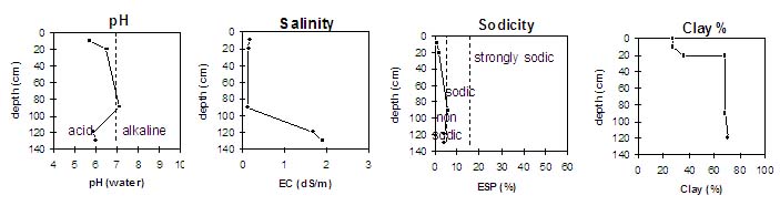
Soil Profile Characteristics:
pH | Salinity Rating | |||
Surface Soil (A1 horizon) | Moderately Acid | Low | Non Sodic | None |
Upper Subsoil (20- 90 cm) | Near Neutral | Low | Marginally Sodic | Moderate 1 |
Deeper Subsoil (at 120+ cm) | Moderately Acid | High-Very High | Non Sodic | None |
 |
Horizon | Horizon Depth (cm) | pH (water) | pH (CaCl2) | EC 1:5 | NaCI % | Exchangeable Cations | |||
Ca | Mg | K | Na | ||||||
meq/100g | |||||||||
A11 | 0-10 | 5.7 | 5.2 | 0.17 | 14 | 11 | 1.1 | 0.50 | |
A12 | 10-20 | 6.5 | 5.9 | 0.15 | 12 | 14 | 1.1 | 0.73 | |
B21 | 20-90 | 7.1 | 6.4 | 0.13 | 14 | 25 | 1.3 | 2.4 | |
B22 | 90-120 | 5.9 | 5.6 | 1.7 | 0.32 | 13 | 20 | 0.4 | 1.7 |
B23 | 120+ | 6.0 | 5.8 | 1.9 | 0.31 | 12 | 20 | 0.5 | 1.6 |
Horizon | Horizon Depth (cm) | Exchangeable Aluminium mg/kg | Exchangeable Acidity meq/100g | Field Capacity pF2.5 | Wilting Point pF4.2 | Coarse Sand (0.2- 2.0 mm) | Fine Sand (0.02- 0.2 mm) | Silt (0.002- 0.02 mm) | Clay (<0.002 mm) |
A11 | 0-10 | 12 | 33 | 26 | 35 | 8 | 13 | 28 | |
A12 | 10-20 | 35 | 21 | 37 | 8 | 11 | 37 | ||
B21 | 20-90 | 60 | 33 | 1 | 8 | 15 | 69 | ||
B22 | 90-120 | 11 | 12 | 63 | 33 | 1 | 9 | 17 | 71 |
B23 | 120+ | 11 |
Profile Described By: Mark Imhof, Paul Rampant (January 2001).