Victorian Resources Online (archived)
PVI2
Location: PVI Hamilton
Australian Soil Classification: Vertic (&Ferric), Eutrophic, Yellow SODOSOL (thick, clay loamy surface)
Northcote Factual Key: Dy3.42
Geology: Tertiary/Quaternary basalt.
General Landscape Description: Mid-slope of a low rise (lower lying position).
Soil Mapping Unit: Monivae gravelly loam (slope phase).
Site Description: Edge of a cereal cropping paddock.
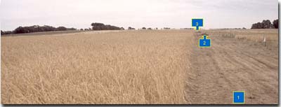 PVI2 Landscape |
Soil Profile Morphology:
Surface Soil
| A1 | 0-20 cm | Brown (10YR4/3); very fine sandy clay loam; weak coarse blocky (occasionally parting to strong coarse to medium polyhedral structure); very weak consistence (dry); pH 5.5; clear change to: | 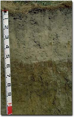 PVI2 Profile |
| A21 | 20-40 cm | Yellowish brown (10YR5/4) with strong brown (7.5YR5/8) mottles; conspicuously bleached (10YR7/2 dry); fine sandy clay loam; massive; strong consistence (dry); pH 6.0; clear change to: | |
| A22 | 40-55 cm | Yellowish brown (10YR5/4); conspicuously bleached (10YR7/2 dry); fine sandy clay loam; massive; firm consistence (dry); very many (80%) ferruginous nodules; (2-10 mm size); pH 6.3; abrupt and wavy change to: | |
| Subsoil | |||
| B21 | 55-65 cm | Brownish yellow (10YR6/6) with brown (10YR4/3) and dark red (2.5YR4/8) mottles; medium clay; moderate coarse blocky, parting to strong medium blocky structure; some dark staining on ped faces; very firm consistence (moist); pH 7.1; clear change to: Note: In some areas the upper subsoil (B21 horizon) can be darker (10YR4/4) with brownish yellow (10YR6/6) mottles. In these areas, there is usually less ferruginous gravel in the A2 horizon. These variations are associated with the original gilgai micro-relief. | |
| B22 | 65-90 cm | Brownish yellow (10YR6/8) with very dark greyish brown (10YR3/2) mottles; medium clay; moderate to strong coarse prismatic, parting to moderate to strong medium prismatic and moderate coarse to medium blocky structure; some manganese stains; very firm consistence (moist); pH 7.1; gradual change to: | |
| B23 | 90-120+ cm | Brownish yellow (10YR6/6) with many (40%) light grey (2.5Y7/2) mottles; medium heavy clay; strong lenticular structure; firm consistence (moist); pH 7.2. | |
Key Profile Features:
- Variation in soil profile features associated with gilgai micro-relief.
- Strong texture contrast between surface (A) horizons and subsoil (B) horizons.
- Thick conspicuously bleached subsurface (A2) horizons.
- Large amount of ferruginous nodules in the subsurface (A22) horizon.
- Vertic properties (i.e. lenticular peds) in the deep subsoil.
pH | Salinity Rating | |||
Surface Soil (A1 horizon) | Strongly Acid | Low | Non-Sodic | None |
Upper Subsoil (55 - 65 cm) | Near Neutral | Low | Marginally Sodic | None |
Deep Subsoil (at 90 - 120 cm) | Near Neutral | Low | Sodic | None |
 |  |  |  |
Horizon | Horizon Depth (cm) | pH (water) | pH (CaCl2) | EC 1:5 | Exchangeable Cations | |||
Ca | Mg | K | Na | |||||
meq/100g | ||||||||
A1 | 0-20 | 5.5 | 4.2 | 0.09 | 3.5 | 1.7 | 0.28 | 0.28 |
A21 | 20-40 | 6.0 | 4.8 | <0.05 | 2.2 | 1.3 | 0.10 | 0.17 |
A22 | 40-55 | 6.3 | 5.2 | <0.05 | 2.4 | 1.5 | 0.13 | 0.18 |
B21 | 55-65 | 7.1 | 5.8 | 0.08 | 3.9 | 6.5 | 0.33 | 1.2 |
B22 | 65-90 | 7.1 | 5.7 | 0.11 | 4.9 | 8.9 | 0.33 | 1.9 |
B23 | 90-120 | 7.2 | 5.9 | 0.17 | 4.8 | 9.8 | 0.28 | 2.9 |
Horizon | Horizon Depth (cm) | Exchangeable Acidity meq/100g | Field Capacity pF2.5 | Wilting Point pF4.2 | Coarse Sand (0.2- 2.0 mm) | Fine Sand (0.02- 0.2 mm) | Silt (0.002- 0.02 mm) | Clay (<0.002 mm) |
A1 | 0-20 | 37 | 11 | 4 | 40 | 29 | 19 | |
A21 | 20-40 | 26 | 8 | 11 | 40 | 29 | 19 | |
A22 | 40-55 | 17 | 9 | 55 | 16 | 13 | 15 | |
B21 | 55-65 | 8.7 | 40 | 24 | 10 | 17 | 10 | 62 |
B22 | 65-90 | 50 | 30 | 1 | 10 | 7 | 81 | |
B23 | 90-120 | 52 | 30 | 3 | 13 | 9 | 76 |
Profile Described By: Mark Imhof, Paul Rampant (January 2001).