Victorian Resources Online (archived)
PVI5
Location: PVI Hamilton
Australian Soil Classification: Terric, Basic, Sapric ORGANOSOL
Northcote Factual Key: O
Great Soil Group: Possibly a prairie soil.
Geology: Alluvium overlying quaternary basalt.
General Landscape Description: Broad depression (drained swamp).
Soil Mapping Unit: Tabor loam (peaty phase).
Site Description: Grazing paddock.
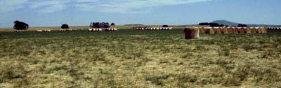 PVI5 Landscape |
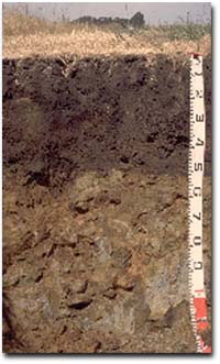
Soil Profile Morphology:
Surface Soil
| A1 | 0-20 cm | Black (10YR2/1); loam; weak coarse blocky structure; very weak consistence (dry); pH 5.8; clear change to: | 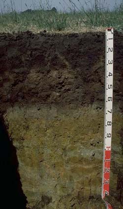 PVI5 Profile |
| Subsoil | |||
| B21 | 20-30 cm | Black (10YR2/1); fine sandy clay loam (organic); strong medium polyhedral, parting to strong fine to very fine polyhedral structure; very firm consistence (dry); pH 5.8; sharp change to: | |
| P21 | 30-45 cm | Very pale brown (10YR7/3); laminated sapric peat; sharp change to: | |
| P22 | 45-60 cm | Very dark grey (10YR3/1); clayey peat; sharp change to: | |
| D1 | 60-70 cm | Grey (5Y5/1); medium clay; pH 7.0; clear change to: | |
| D2 | 70-80 cm | Grey (5Y6/1) with yellow (5Y7/6) mottles; sandy clay; sharp change to: | |
| D3 | 80+ cm | Pale olive (5Y6/4); sandy clay loam; pH 8.0; rusty root channel mottling. | |
Key Profile Features:
| |||
pH | Salinity Rating | |||
Surface Soil (A1 horizon) | Moderately Acid | Low | Non-Sodic | None |
Upper Subsoil (20 - 30 cm) | Moderately Acid | Low | Non-Sodic | None |
Deeper Subsoil (at 60-70 cm) | Moderately Alkaline | High | Non-Sodic | - |
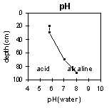 | 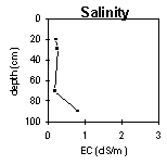 |  |
Horizon | Horizon Depth (cm) | pH (water) | pH (CaCl2) | EC 1:5 | Exchangeable Cations | |||
Ca | Mg | K | Na | |||||
meq/100g | ||||||||
A1 | 0-20 | 5.8 | 5.6 | 0.21 | 32 | 16 | 0.27 | 1.3 |
B21 | 20-30 | 5.8 | 5.7 | 0.25 | 39 | 22 | 0.72 | 1.7 |
P21 | 30-45 |
| ||||||
P22 | 45-60 | |||||||
D1 | 60-70 | 7.0 | 6.0 | 0.20 | 9.8 | 12 | 0.43 | 1.2 |
D3 | 80+ | 8.0 | 7.6 | 0.81 | ||||
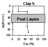
Horizon | Horizon Depth (cm) | Exchangeable Aluminium mg/kg | Exchangeable Acidity meq/100g | Field Capacity pF2.5 | Wilting Point pF4.2 | Coarse Sand (0.2- 2.0 mm) | Fine Sand (0.02- 0.2 mm) | Silt (0.002- 0.02 mm) | Clay (<0.002 mm) |
A1 | 0-20 | 23 | 30 | 73 | 53 | 39 | 9 | 12 | 18 |
B21 | 20-30 | 28 | 31 | 77 | 64 | 7 | 37 | 6 | 47 |
P21 | 30-45 |
| |||||||
P22 | 45-60 | ||||||||
D1 | 60-70 | 7 | 37 | 6 | 47 | ||||
D3 | 80+ | 6 | 21 | 18 | 50 | ||||
 PVI5a Profile Paralithic, Basic, Sapric ORGANOSOL Note: In some areas of the paddock the weathered basalt occurs within 50 cm of the soil surface. |
|
Profile Described By: Mark Imhof, Paul Rampant (January 2001).