Victorian Resources Online (archived)
PVI6
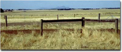
Location: PVI Hamilton.
Australian Soil Classification: Ferric-Sodic, Mesotrophic, Brown CHROMOSOL (thick, clay loamy surface - moderate profile depth).
Northcote Factual Key: Db 2.41
Great Soil Group: Possibly brown podzolic.
Geology: Tertiary/Quaternary basalt..
General Landscape Description: Crest of low rise.
Soil Mapping Unit: Monivae gravelly loam (crest phase).
Site Description: Grazing paddock.
 PVI6 Landscape |
Soil Profile Morphology:
Surface Soil
| A1 | 0-20 cm | Very dark greyish brown (10YR3/2); fine sandy clay loam; weak coarse blocky; weak consistence (dry); rusty root channel mottles; pH 5.3; clear change to: | 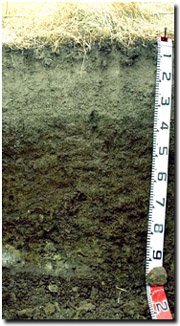 PVI6 Profile |
| A2 | 20-35 cm | Brown (10YR5/3); clay loam (fine sandy); firm consistence (dry); very many (60%) ferruginous nodules (2-12 mm); few (10%) basalt fragments (5-12 mm); pH 5.8; abrupt change to: | |
| Subsoil | |||
| B21 | 35-50 cm | Brown (10YR4/3) with few (5%) faint dark yellowish brown (10YR4/6) mottles; light medium clay; strong coarse blocky, parting to strong medium to fine polyhedral structure; strong consistence (dry); pH 5.6; clear change to: | |
| B22 | 50-70 cm | Dark greyish brown (10YR4/2) with yellowish brown (10YR5/6) and strong brown (7.5YR4/8) mottles; medium heavy clay; strong coarse blocky, parting to strong medium to fine polyhedral structure; very firm consistence (dry); pH 5.8; gradual change to: | |
| B23 | 70-90 cm | Dark grey (10YR4/1) with yellowish brown (10YR5/8) and strong brown (7.5YR5/6) mottles; medium heavy clay; strong coarse to medium blocky structure; strong consistence (dry); pH 6.2; gradual change to: | |
| C | 90+ cm | Weathered basalt. | |
Key Profile Features:
| |||
pH | Salinity Rating | |||
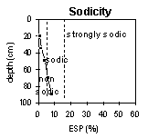
Surface Soil (A1 horizon) | Strongly Acid | Low | Non-Sodic | None |
Upper Subsoil (35 - 50 cm) | Moderately Acid | Low | Non-Sodic | None |
Deep Subsoil (at 70 - 90 cm) | Slightly Acid | Low | Sodic | None |
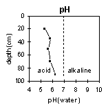 | 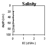 |  |  |
Horizon | Horizon Depth (cm) | pH (water) | pH (CaCl2) | EC 1:5 | Exchangeable Cations | |||
Ca | Mg | K | Na | |||||
meq/100g | ||||||||
A1 | 0-20 | 5.3 | 4.6 | 0.07 | 4.3 | 1.47 | 0.11 | 0.18 |
A2 | 20-35 | 5.8 | 5.0 | 0.07 | 2.9 | 2.4 | 0.11 | 0.31 |
B21 | 35-50 | 5.6 | 4.6 | 0.07 | 3.0 | 6.1 | 0.15 | 0.87 |
B22 | 50-70 | 5.8 | 4.8 | 0.10 | 2.7 | 7.9 | 0.15 | 1.5 |
B23 | 70-90 | 6.2 | 5.5 | 0.12 | 3.0 | 8.9 | 0.17 | 2.2 |
Horizon | Horizon Depth (cm) | Exchangeable Aluminium mg/kg | Exchangeable Acidity meq/100g | Field Capacity pF2.5 | Wilting Point pF4.2 | Coarse Sand (0.2- 2.0 mm) | Fine Sand (0.02- 0.2 mm) | Silt (0.002- 0.02 mm) | Clay (<0.002 mm) |
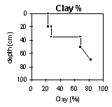
A1 | 0-20 | 16 | 39 | 20 | 11 | 34 | 25 | 23 | |
A2 | 20-35 | <10 | 27 | 12 | 22 | 25 | 20 | 28 | |
B21 | 35-50 | 32 | 11 | 41 | 26 | 2 | 14 | 11 | 69 |
B22 | 50-70 | 21 | 15 | 47 | 31 | 1 | 5 | 8 | 83 |
B23 | 70-90 | <10 | 50 | 31 | 2 | 6 | 10 | 80 |
Profile Described By: Mark Imhof, Paul Rampant (January 2001).