Victorian Resources Online (archived)
PVI9
Location: PVI Hamilton
Australian Soil Classification: Bleached-Vertic (&Ferric-Sodic), Eutrophic, Brown CHROMOSOL (thick, clay loamy surface)
Northcote Factual Key: Dy 3.42
Great Soil Group: Possibly brown podzolic
Geology: Tertiary/Quaternary basalt.
General Landscape Description: Valley flat beneath rises.
Soil Mapping Unit: Monivae clay loam.
Site Description: Grazing paddock.
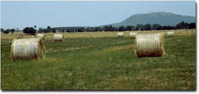 PVI9 Landscape |
Soil Profile Morphology:
Surface Soil
| A1 | 0-15 cm | Dark brown (10YR3/3); very fine sandy clay loam; weak coarse blocky structure; very firm consistence (dry); pH 5.3; clear change to: | 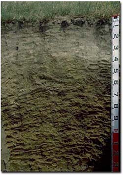 PVI9 Profile |
| A2 | 15-40 cm | Brown (10YR5/3); conspicuously bleached (10YR7/1 dry); light fine sandy clay loam; massive structure; very firm consistence (dry); pH 5.9; abrupt change to: | |
| Subsoil | |||
| B1 | 40-50 cm | Brown (10YR5/3); light medium clay; weakly structured; very strong consistence (dry); pH 6.6; clear change to: | |
| B21 | 50-65 cm | Brown (10YR5/3) with brownish yellow (10YR6/6 and 6/8) mottles; medium clay; very strong consistence (dry); many (30%) ferruginous nodules (2-4 mm); pH 6.6; gradual change to: | |
| B22 | 65-100 cm | Yellowish brown (10YR5/4) with brownish yellow (10YR6/6 and 6/8) mottles; medium heavy clay; moderate coarse blocky, parting to lenticular structure; very strong consistence (moist); many (20-40%) ferruginous nodules (2-6 mm); some manganese stains; pH 6.7: | |
| B23 | 100+ cm | Light brownish grey (10YR6/2) with many (40%) brownish yellow (10YR6/8) and dark red (2.5YR4/8) mottles; weak coarse prismatic, parting to moderate lenticular structure; rigid consistence (moist); contains few (5%) ferruginous nodules (2-6 mm); pH 6.7. | |
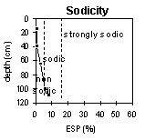
Key Profile Features:
- Strong texture contrast between the surface (A) horizons and subsoil (B21) horizon.
- Conspicuously bleached subsurface (A2) horizon.
- Vertic properties in the deeper subsoil (i.e. lenticular structure).
pH | Salinity Rating | |||
Surface Soil (A1 horizon) | Strongly Acid | Low | - | None |
Upper Subsoil (40 - 50 cm) | Slightly Acid | Low | Non-Sodic | None |
Deep Subsoil (at 100+ cm) | Slightly Acid | Low | Sodic | None |
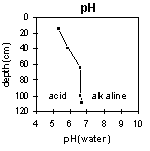 | 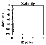 |  |  |
Horizon | Horizon Depth (cm) | pH (water) | pH (CaCl2) | EC 1:5 | NaCl2 | Exchangeable Cations | |||
Ca | Mg | K | Na | ||||||
meq/100g | |||||||||
A1 | 0-15 | 5.3 | 4.8 | 0.10 | 4.8 | 1.5 | 0.12 | 0.18 | |
A2 | 15-40 | 5.9 | 5.2 | <0.05 | 2.7 | 0.77 | <0.05 | 0.08 | |
B21 | 50-65 | 6.6 | 5.7 | 0.06 | <0.01 | 3.6 | 4.2 | 0.12 | 0.45 |
B22 | 65-100 | 6.6 | 6.0 | 0.13 | 4.9 | 7.7 | 0.22 | 1.3 | |
B23 | 100+ | 6.7 | 6.0 | 0.12 | 4.4 | 7.7 | 0.17 | 1.7 | |
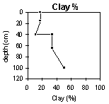
Horizon | Horizon Depth (cm) | Exchangeable Aluminium mg/kg | Exchangeable Acidity meq/100g | Field Capacity pF2.5 | Wilting Point pF4.2 | Coarse Sand (0.2- 2.0 mm) | Fine Sand (0.02- 0.2 mm) | Silt (0.002- 0.02 mm) | Clay (<0.002 mm) |
A1 | 0-15 | 10 | 38 | 9 | 3 | 40 | 31 | 18 | |
A2 | 15-40 | <10 | 24 | 4 | 3 | 50 | 32 | 11 | |
B21 | 50-65 | 6.7 | 27 | 13 | 7 | 38 | 23 | 34 | |
B22 | 65-100 | 8.9 | 35 | 21 | 12 | 19 | 15 | 50 | |
B23 | 100+ |
Profile Described By: Mark Imhof, Paul Rampant (January 2001).