Victorian Resources Online (archived)
SFS6
Location: Cardigan
Australian Soil Classification: Vertic (& Ferric), Mottled-Mesonatric, Yellow SODOSOL
General Landscape Description: Plain within the Victorian volcanic plains.
Site Description: Slope with gilgai microrelief. Profile description midway down gilgai hollow.
Land Use: Raised bed cropping.
Soil Type: Similar to SFS5a & SFS5b.
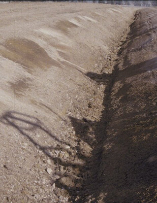 |  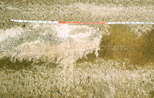 SFS6 Profile. Measuring tape shows the gilgai across the profile face over a 3 m width, rather than the depth of the profile. | |
|
Soil Profile Morphology:
| Surface Soil | 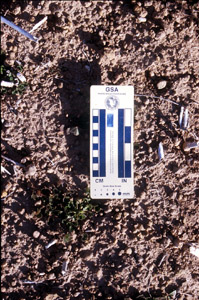 SFS6 Soil surface. | ||
| Ap | 0 – 15 cm | Surface is weak and powdery with a surface seal, >10 % of surface has exposed coarse buckshot where <10 % is magnetic; brown (10YR4/3); fine sandy clay loam; apedal; firm consistence dry; pH 5.7; clear change to: | |
| A2c | 15 – 40/45 cm | Pale brown (10YR6/3) conspicuously bleached (10YR7/3 dry); light fine sandy clay loam; apedal; abundant (~50 %) medium (5-25 mm) buckshot gravel that is hard but can be broken with some finger force having black manganiferous centres becoming cemented at base of horizon; pH 5.4; clear change to: | |
| Subsoil | |||
| B1c | 40/45 – 60 cm | Fine sandy clay loam; abundant (~80 %) medium to coarse (10-40 mm) manganiferous buckshot/ironstone gravel; pH 6.7; abrupt change to: | |
| B21tg | 60 – 120+ cm | Light yellowish brown (2.5Y6/4) with prominent small linear dark red (2.5YR4/8) mottles with a brownish yellow (10YR6/8) fringe; light medium clay; fine (5-10 mm) polyhedral structure; pH 7.2. | |
Key Profile Features:
- Lateral variation in soil horizons due to gilgai microrelief (e.g. variations in subsurface A1 horizon thickness).
Soil Profile Characteristics:
pH | Salinity Rating | |||
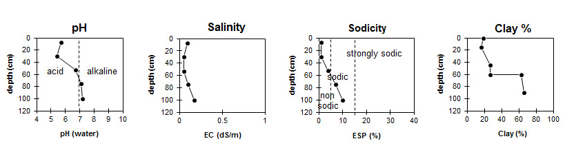
Surface (A1 horizon) | Moderately Acid | Low | Non-Sodic | None |
Subsoil (B21 horizon higher) | Neutral | Very Low | Sodic | None |
Deeper Subsoil (B21 horizon lower) | Slightly Alkaline | Low | Sodic | None |
Horizon | Horizon Depth (cm) | pH (water) | pH (CaCl2) | EC dS/m | Organic Carbon % | Nitrogen % | Exchangeable Cations | |||
Ca | Mg | K | Na | |||||||
meq/100g | ||||||||||
Ap | 0-15 | 5.7 | 4.9 | 0.09 | 1.2 | 0.11 | 3.1 | 0.81 | 0.38 | 0.14 |
A2 | 15-40/45 | 5.4 | 4.6 | <0.05 | 1.9 | 0.51 | 0.17 | 0.08 | ||
B1 | 40/45-60 | 6.7 | 5.7 | 0.05 | 2.1 | 2.6 | 0.17 | 0.51 | ||
B21 (Higher) | 60-90 | 7.0 | 6.0 | 0.1 | 3.6 | 8.2 | 0.29 | 1.7 | ||
B21 (Lower) | 90-120 | 7.2 | 6.3 | 0.17 | 3.9 | 10 | 0.35 | 2.6 | ||
Horizon | Horizon Depth (cm) | Exchangeable Aluminium mg/kg | Exchangeable Acidity meq/100g | Field Capacity pF2.5 | Wilting Point pF4.2 | Coarse Sand (0.2-2.0 mm) | Fine Sand (0.02-0.2 mm) | Silt (0.002-0.02 mm) | Clay (<0.002 mm) |
Ap | 0-15 | <10 | 6.9 | 29 | 7.0 | 4 | 46 | 25 | 19 |
A2 | 15-40/45 | 18 | 6.5 | 27.9 | 18.5 | 8 | 46 | 25 | 16 |
B1 | 40/45-60 | 6.3 | 27.3 | 9.9 | 11 | 39 | 20 | 27 | |
B21 (Higher) | 60-90 | 9.4 | 39.0 | 22.6 | 6 | 8 | 15 | 63 | |
B21 (Lower) | 90-120 | 9.4 | 46.0 | 25.1 | 3 | 16 | 12 | 66 |
Management Considerations:
Whole Profile
- Plant available water capacity (PAWC) in the gilgai hollow is considered to be low (estimated at 88 mm) in the upper 100 cm of this soil profile.