Victorian Resources Online (archived)
SFS8
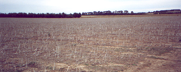
Location: Minhamite
Australian Soil Classification: Vertic (& Ferric), Mottled-Subnatric, Black SODOSOL
Great Soil Group: Solodic
General Landscape Description: Victorian volcanic plains.
Site Description: Low lying, gently sloping flat to convex.
Land Use: Canola cropping stubble. Raised bed with rounded bed edges.
Geology: Tertiary (Hanson Plain Sand / Moorabool Viaduct Formation).
 SFS8 Landscape |
Soil Profile Morphology:
| Surface Soil | 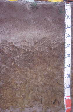 SFS8 Profile | ||
| Ap | 0-20 cm | Weak surface crust with fine buckshot (firm consistence); dark greyish brown (10YR4/2); loam; apedal to very weakly pedal; pH 5.5; abrupt change to: | |
| A2c | 20-40/70 cm | Light olive brown (2.5Y5/4) conspicuously bleached (10YR7/1 dry); fine gravel; pH 5.5; smooth and abrupt change to: NOTE: Insufficient fine earth to do texture. NOTE: Deeper A2 - fine sandy loam; non gravelly with very minor buckshot. | |
| Subsoil | |||
| B21 | 40/70-80 cm | Very dark greyish brown (10YR3/2) with fine yellow and red (10YR8/8) mottles; medium heavy clay (clay is tough and dense); very fine polyhedral structure; very minor buckshot; fine roots throughout; pH 6.8; diffuse change to: | |
| B22 | 80+ cm | Olive brown (2.5Y4/4) with light olive brown (2.5Y5/6) mottles; medium heavy clay (clay is tough and dense); fine polyhedral and very fine prismatic structure; clay and organic matter coatings on ped faces; small (110 mm) slickensides at base of pit; fine roots throughout; pH 7.7. | |
Key Profile Features:
- Strong texture contrast between surface (A) horizon and subsoil (B21) horizon.
- Conspicuously bleached subsurface (A) horizon with ferruginous nodules (‘buckshot’).
- The fine B horizon structure has been penetrated by crop roots.
Soil Profile Characteristics:
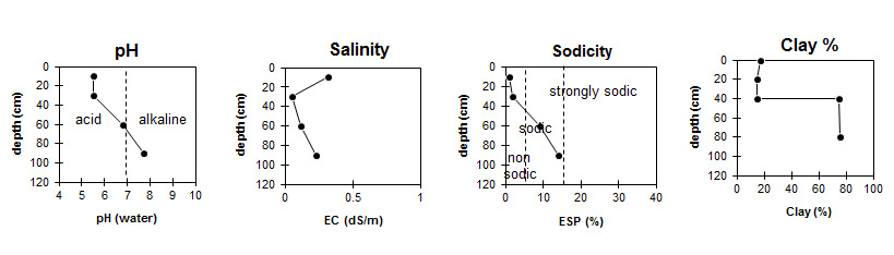
pH | Salinity Rating | |||
Surface (A1 horizon) | Strongly Acid | Medium-High | Non-Sodic | None |
Subsoil (B21 horizon) | Slightly Acid | Very Low | Sodic | None1 |
Deeper Subsoil (at 80+ cm) | Slightly Alkaline | Low | Strongly Sodic | None1 |
Chemical and Physical Analysis:
Horizon | Horizon Depth (cm) | pH (water) | pH (CaCl2) | EC dS/m | NaCl % | Organic Carbon % | Total Nitrogen % | Exchangeable Aluminium ppm | Exchangeable Acididty meq/100g | Exchangeable Cations | Coarse Sand (0.2-2.0 mm) % | Fine Sand (0.02-0.2 mm) % | Silt (0.002-0.02 mm) % | Clay (<0.002 mm) % | Field Capacity % w/w | Wilting Point % w/w | |||
Ca | Mg | K | Na | ||||||||||||||||
meq/100g | |||||||||||||||||||
Ap | 0-20 | 5.5 | 5 | 0.32 | 0.02 | 3.1 | 0.3 | <10 | 11 | 6 | 1.3 | 0.2 | <0.1 | 5 | 40 | 34 | 17 | 36.3 | 12.7 |
A2 | 20-40/70 | 5.5 | 4.5 | 0.05 | 22 | 6.3 | 1.3 | 1.4 | 0.07 | 0.23 | 5 | 46 | 33 | 15 | 27.5 | 5.8 | |||
B21 | 40/70-80 | 6.8 | 5.5 | 0.12 | 12 | 4.1 | 12 | 0.4 | 2.9 | 3 | 12 | 8 | 75 | 49.1 | 29.9 | ||||
B22 | 80+ | 7.7 | 6.6 | 0.23 | 8.1 | 4.8 | 13 | 0.37 | 4.3 | 2 | 13 | 7 | 76 | 52.6 | 30.8 | ||||
Management Considerations:
Whole Profile
- Plant available water capacity (PAWC) is considered to be medium (estimated at 102 mm) in the upper 100 cm of this soil profile.
Profile Described By: Richard MacEwan (May 1999).