Victorian Resources Online (archived)
SFS9a
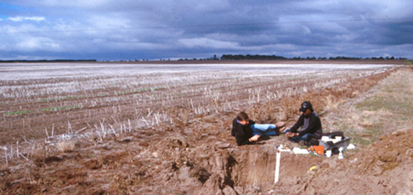
Location: Woodhouse
Australian Soil Classification: Vertic (& Ferric), Mottled-Subnatric, Grey SODOSOL
Northcote Factual Key: Dy3.42
General Landscape Description: Level plain within the Victorian volcanic plains. Flat, gently sloping on the side of broad depression.
Site Description: Depression or 'hollow' component of gilgai micro-relief.
Land Use: Raised beds with canola.
 SFS9a Landscape |
Soil Profile Morphology:
| Surface Soil |  SFS9a Profile | ||
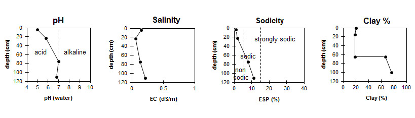
| A1 | 0-8/10 cm | Dark greyish brown (10YR4/2) with rusty root channel mottling; loam; apedal; weak consistence dry; pH 5; clear and wavy change to: | |
| A2 | 8/10-60 cm | Brown (10YR5/3) with conspicuous bleach (10YR6/2d) and yellow mottles; clay loam, fine sandy; lower part of horizon (40-60 cm depth) has abundant (~90%) buckshot; pH 5.8; clear and abrupt change to: | |
| Subsoil | |||
| B21tc | 60-100 cm | Dark grey (10YR4/1) with common brownish yellow (10YR6/8) and dark red (2.5YR4/8) mottles; heavy clay; common (10-20%) buckshot; friable in a moist condition; fine polyhedral and lenticular structure; pH 7.0; gradual change to: | |
| B22 | 100+ cm | Dark grey (10YR4/1) with many brownish yellow (10YR6/8) mottles and very few dark red (2.5YR4/8) mottles disappearing at depth; medium heavy clay; fine polyhedral and lenticular structure; pH 6.8. | |
Key Profile Features:
- Strong texture contrast between surface (A) horizon and subsoil (B21) horizon.
- Conspicuously bleached subsurface (A2) horizon.
- Buckshot in A2 is only in lower 10cm of horizon.
Soil Profile Characteristics:
pH | Salinity Rating | |||
Surface (A1 horizon) | Strongly Acid | Low | Non-Sodic | None |
Subsoil (B21 horizon) | Neutral | Very Low | Sodic | None1 |
Deeper Subsoil (B22 horizon) | Slightly Acid | Low | Sodic | None |
Horizon | Horizon Depth (cm) | pH (water) | pH (CaCl2) | EC dS/m | Organic Carbon % | Nitrogen % | Exchangeable Cations | |||
Ca | Mg | K | Na | |||||||
meq/100g | ||||||||||
A1 | 0-8/10 | 5 | 4.4 | 0.15 | 4.3 | 0.36 | 4.2 | 1.6 | 0.22 | 0.35 |
A2 | 15-30 | 5.8 | 4.9 | 0.06 | 3.2 | 1.4 | 0.08 | 0.25 | ||
B21k | 65-85 | 7 | 7 | 0.13 | 4 | 9.1 | 0.25 | 2.2 | ||
B22 | 100+ | 6.8 | 6.5 | 0.21 | 4.5 | 11 | 0.27 | 3.3 | ||
Horizon | Horizon Depth (cm) | Exchangeable Aluminium mg/kg | Exchangeable Acidity meq/100g | Field Capacity pF2.5 | Wilting Point pF4.2 | Coarse Sand (0.2-2.0 mm) | Fine Sand (0.02-0.2 mm) | Silt (0.002-0.02 mm) | Clay (<0.002 mm) |
A1 | 0-8/10 | 37 | 14 | 34.6 | 12.1 | 5 | 39 | 28 | 20 |
A2 | 15-30 | <10 | 6.7 | 30.1 | 7.6 | 3 | 43 | 32 | 19 |
B21k | 65-85 | 12 | 40.7 | 26.7 | 9 | 12 | 8 | 67 | |
B22 | 100+ | 11 | 45.4 | 29.8 | 3 | 10 | 8 | 76 |
Management Considerations:
Whole Profile
- Plant available water capacity (PAWC) is considered to be medium (estimated at 107 mm) in the upper 100 cm of this soil profile.
- This site had more earthworms than has been seen at any other SFS site.