Victorian Resources Online (archived)
SM01
Location: Buckley Swamp
Australian Soil Classification: Melacic-Mottled (& Vertic), Eutrophic, Brown CHROMOSOL
General Landscape Description: Undulating lava plain adjacent to Buckley Swamp.
Site Description: Mid slope.
Land Use: Grazing.
Geology: Basalt.
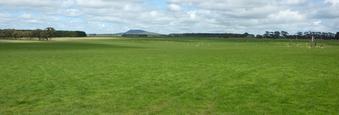
SM01 Landscape - pit in the foreground.
Soil Profile Morphology:
| Surface Soil | 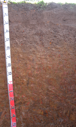 SM01 profile | ||
| A11 | 0-13 cm | Very dark greyish brown (10YR3/2); firm surface condition; light clay loam (fine sandy); strong medium polyhedral, parting to very fine polyhedral structure; rough fabric; weak consistence moderately moist; many fine roots present; pH 5.1; clear change to: | |
| A12 | 13-30 cm | Very dark greyish brown (10YR3/2); clay loam; moderate medium polyhedral, parting to very fine polyhedral structure; rough fabric; very weak consistence moist; contains very few ferro-manganiferous nodules; many fine roots present; pH 5.1; clear change to: | |
| A2 | 30-55 cm | Brown (7.5YR4/3); clay loam; weak coarse polyhedral, parting to fine polyhedral structure; rough fabric; weak consistence moderately moist; gravelly ferro-manganiferous nodules abundant; fine roots common; pH 6.1; clear change to: | |
| Subsoil | |||
| B21 | 55-80 cm | Yellowish brown (10YR5/4) with faint dark red (2.5YR4/8) mottles common; medium clay; moderate medium prismatic, parting to very fine polyhedral structure; smooth fabric; weak consistence moist; gravelly ferro-manganiferous nodules common; very fine roots common; pH 6.6; diffuse change to: | |
| B22 | 80-130 cm | Dark yellowish brown (10YR4/6) with many coarse distinct dark yellowish brown (10YR4/4) and dark red (2.5YR4/8) mottles; medium clay; moderate coarse lenticular, parting to fine angular blocky structure; smooth fabric; weak consistence moist; faint slickensides common with few distinct organo-clay cutans evident; very few very fine roots present; pH 6.4; clear change to: | |
| BC | 130-150+ cm | Greyish brown (10YR5/2) with many very coarse prominent dark red (2.5YR4/6) and light grey (5Y7/1) mottles; medium heavy clay; moderate coarse lenticular, parting to moderate angular blocky structure; smooth fabric; firm consistence moist; many distinct slickensides evident; contains few very weathered basalt fragments; very few very fine roots present; pH 6.6. | |
Soil Profile Characteristics:
pH | Salinity Rating | |||
Surface (A1 horizon) | Strongly Acid | Very Low | Non Sodic | None |
Subsoil (B21 horizon) | Slightly Acid | Very Low | Non Sodic | None |
Deeper Subsoil (at 80-130+ cm) | Slightly Acid | Very Low | Sodic | None |
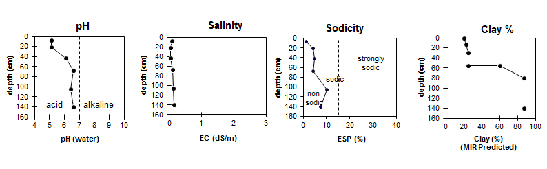
| The surface soil is strongly acid. The subsoil is slightly acid. | The salinity rating is very low throughout the profile.
| The surface and the upper subsoil are non-sodic. The deeper subsoil is sodic. | The MIR predicted clay content increases markedly at the A / B boundary. |
Horizon | Horizon Depth (cm) | pH (water) | pH (CaCl2) | EC dS/m | Total Carbon g/100g | Exchangeable Aluminium mg/kg | Exchangeable Acidity meq/100g | Exchangeable Cations | |||
Ca | Mg | K | Na | ||||||||
meq/100g | |||||||||||
A11 | 0 – 13 | 5.1 | 4.3 | 0.09 | 4.2 | 64 | 15 | 3.4 | 1.3 | 0.22 | 0.26 |
A12 | 13 - 30 | 5.1 | 4.2 | 0.05 | 2.6 | 0.9 | 0.15 | 0.16 | |||
A2 | 30 -55 | 6.1 | 5.2 | 0.05 | 2.9 | 1.3 | 0.08 | 0.22 | |||
B21 | 55 - 80 | 6.6 | 5.7 | 0.10 | 11 | 4.6 | 5.9 | 0.14 | 0.98 | ||
B22 | 80 - 130 | 6.4 | 5.8 | 0.13 | 4.3 | 7.7 | 0.15 | 1.4 | |||
B23 | 130 - 150+ | 6.6 | 5.8 | 0.14 | 9.9 | 4.4 | 11 | 0.11 | 2.1 | ||
Horizon | Horizon Depth (cm) | Field Capacity pF2.5 (MIR Predicted) | Wilting Point pF4.2 (MIR Predicted) | Coarse Sand (0.2-2.0mm) (MIR Predicted) | Fine Sand (0.02-0.2mm) (MIR Predicted) | Silt (0.002-0.02mm) (MIR Predicted) | Clay (<0.002mm) (MIR Predicted) |
A11 | 0 – 13 | 28.9 | 12.0 | 11 | 34 | 22 | 20 |
A12 | 13 - 30 | 25.6 | 12.4 | 9 | 31 | 24 | 23 |
A2 | 30 -55 | 23.8 | 12.4 | 11 | 32 | 19 | 25 |
B21 | 55 - 80 | 37.3 | 23.6 | 7 | 16 | 12 | 60 |
B22 | 80 - 130 | 48.6 | 33.8 | 3 | 6 | 11 | 87 |
B23 | 130 - 150+ | 50.5 | 36.2 | 3 | 6 | 14 | 87 |
Profile Described By: David Rees and Ivanah Oliver (September 2014).